
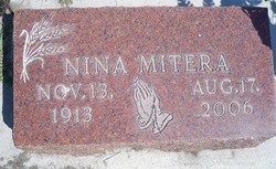
Nina Gladys Roberts Mitera
| Birth | : | 13 Nov 1913 Fullerton, Nance County, Nebraska, USA |
| Death | : | 17 Aug 2006 Columbus, Platte County, Nebraska, USA |
| Burial | : | Pleasington Priory, Pleasington, Blackburn with Darwen Unitary Authority, England |
| Coordinate | : | 53.7348590, -2.5433060 |
| Description | : | Daughter of Oscar W. & Emma (Bartholomew) Roberts. She was raised in western Nebraska before moving to Columbus. Nina was united in marriage to James P. Mitera on June 28, 1933 at St. Anthony Church in Columbus. The couple farmed east of Columbus. Nina loved travel, dancing, and was an avid reader. She was a member of St. Anthony Church, St. Theresa Sodality, Catholic Daughters, Eagles Auxiliary #1834 where she was past president, Home Extension, Kountry Kousins Klub 1939, and American Legion Post #84 Auxiliary. She is survived by: Son J.C. (Mary) Mitera of Hastings, NE Daughter Sandra Williams of Columbus, NE Daughter... Read More |
frequently asked questions (FAQ):
-
Where is Nina Gladys Roberts Mitera's memorial?
Nina Gladys Roberts Mitera's memorial is located at: Pleasington Priory, Pleasington, Blackburn with Darwen Unitary Authority, England.
-
When did Nina Gladys Roberts Mitera death?
Nina Gladys Roberts Mitera death on 17 Aug 2006 in Columbus, Platte County, Nebraska, USA
-
Where are the coordinates of the Nina Gladys Roberts Mitera's memorial?
Latitude: 53.7348590
Longitude: -2.5433060
Family Members:
Flowers:


Nearby Cemetories:
1. Pleasington Priory
Pleasington, Blackburn with Darwen Unitary Authority, England
Coordinate: 53.7348590, -2.5433060
2. Pleasington Cemetery and Crematorium
Blackburn, Blackburn with Darwen Unitary Authority, England
Coordinate: 53.7388880, -2.5368710
3. Holy Trinity Churchyard
Hoghton, Chorley Borough, England
Coordinate: 53.7279300, -2.5848550
4. St. Josephs Roman Catholic Churchyard
Brindle, Chorley Borough, England
Coordinate: 53.7350780, -2.5880640
5. New Row Methodist Church
Blackburn with Darwen Unitary Authority, England
Coordinate: 53.7208950, -2.5023720
6. St Stephen Churchyard
Tockholes, Blackburn with Darwen Unitary Authority, England
Coordinate: 53.7058350, -2.5169320
7. St. Peter's Churchyard
Blackburn, Blackburn with Darwen Unitary Authority, England
Coordinate: 53.7448110, -2.4865070
8. St Paul's
Blackburn, Blackburn with Darwen Unitary Authority, England
Coordinate: 53.7491222, -2.4891266
9. Independent Chapel Churchyard
Blackburn, Blackburn with Darwen Unitary Authority, England
Coordinate: 53.7454960, -2.4864460
10. Wesleyan Methodist Chapel Chapelyard
Blackburn, Blackburn with Darwen Unitary Authority, England
Coordinate: 53.7464910, -2.4848380
11. Blackburn Cathedral
Blackburn, Blackburn with Darwen Unitary Authority, England
Coordinate: 53.7472960, -2.4820020
12. St. Mary's Churchyard
Mellor, Ribble Valley Borough, England
Coordinate: 53.7728600, -2.5312400
13. St Paul's Churchyard
Withnell, Chorley Borough, England
Coordinate: 53.6970740, -2.5592150
14. Mellor Methodist Churchyard
Blackburn, Blackburn with Darwen Unitary Authority, England
Coordinate: 53.7742950, -2.5255060
15. Mount St Presbyterian Chapelyard
Blackburn, Blackburn with Darwen Unitary Authority, England
Coordinate: 53.7478000, -2.4775000
16. Holy Trinity Church
Blackburn with Darwen Unitary Authority, England
Coordinate: 53.7511727, -2.4747178
17. St James's Churchyard
Brindle, Chorley Borough, England
Coordinate: 53.7133333, -2.6086111
18. St Alban's Churchyard
Blackburn, Blackburn with Darwen Unitary Authority, England
Coordinate: 53.7530090, -2.4748540
19. St Mary's R.C. Church Cemetery
Osbaldeston, Ribble Valley Borough, England
Coordinate: 53.7816970, -2.5350240
20. St James Churchyard
Lower Darwen, Blackburn with Darwen Unitary Authority, England
Coordinate: 53.7245510, -2.4634700
21. St Leonard Churchyard
Balderstone, Ribble Valley Borough, England
Coordinate: 53.7860070, -2.5609380
22. Blackburn Cemetery
Blackburn, Blackburn with Darwen Unitary Authority, England
Coordinate: 53.7662430, -2.4726050
23. St. Mary's and St. John RC Churchyard, Southworth
Samlesbury, South Ribble Borough, England
Coordinate: 53.7676690, -2.6183400
24. St. Leonard the Less Churchyard
Samlesbury, South Ribble Borough, England
Coordinate: 53.7680000, -2.6237000