
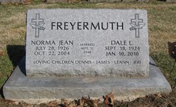
Norma Jean Zierenberg Freyermuth
| Birth | : | 28 Jul 1926 |
| Death | : | 22 Oct 2004 |
| Burial | : | Galata Cemetery, Toole County, USA |
| Coordinate | : | 48.4655991, -111.3349991 |
| Description | : | Norma Jean Freyermuth (nee Zierenberg), 78, Mundelein, Illinois, formerly of West Liberty, died Friday, October 22, 2004, at her home after an extended illness. Graveside services will be held at 1 p.m. Saturday, November 6, at the Oak Ridge Cemetery in West Liberty. After the services, a small reception will be held at the West Liberty Country Club. The Henderson-Barker Funeral Home, West Liberty, is in charge of local arrangements. She was born July 28, 1926, in Thompson, Nebraska. She moved to the West Liberty area with her family in 1941, where she graduated from West Liberty High School in 1943. Survivors... Read More |
frequently asked questions (FAQ):
-
Where is Norma Jean Zierenberg Freyermuth's memorial?
Norma Jean Zierenberg Freyermuth's memorial is located at: Galata Cemetery, Toole County, USA.
-
When did Norma Jean Zierenberg Freyermuth death?
Norma Jean Zierenberg Freyermuth death on 22 Oct 2004 in
-
Where are the coordinates of the Norma Jean Zierenberg Freyermuth's memorial?
Latitude: 48.4655991
Longitude: -111.3349991
Family Members:
Spouse

Flowers:


Nearby Cemetories:
1. Galata Cemetery
Toole County, USA
Coordinate: 48.4655991, -111.3349991
2. Lothair Catholic Cemetery
Lothair, Liberty County, USA
Coordinate: 48.4687000, -111.2484000
3. Lothair Protestant Cemetery
Lothair, Liberty County, USA
Coordinate: 48.4694000, -111.2393100
4. Devon Cemetery
Toole County, USA
Coordinate: 48.4693000, -111.4713000
5. Omholt Cemetery
Toole County, USA
Coordinate: 48.3058014, -111.5346985
6. Saint Olaf Lutheran Cemetery
Toole County, USA
Coordinate: 48.2479000, -111.3182000
7. Dunkirk Cemetery
Dunkirk, Toole County, USA
Coordinate: 48.4797810, -111.6761860
8. Camrose Colony Cemetery
Conrad, Pondera County, USA
Coordinate: 48.3092000, -111.6114000
9. Chester Cemetery
Chester, Liberty County, USA
Coordinate: 48.5219002, -110.9807968
10. Eagle Creek Colony Cemetery
Chester, Liberty County, USA
Coordinate: 48.6976000, -111.2011000
11. Grandview Cemetery
Toole County, USA
Coordinate: 48.7265000, -111.3615000
12. Trinity Church Cemetery
Lothair, Liberty County, USA
Coordinate: 48.7263000, -111.2296000
13. Golden West Cemetery
Conrad, Pondera County, USA
Coordinate: 48.1906013, -111.4957962
14. Erickson Cemetery
Liberty County, USA
Coordinate: 48.3143997, -110.9503021
15. Riverview Colony Cemetery
Riverview Colony, Liberty County, USA
Coordinate: 48.1762000, -111.0315000
16. Mountain View Cemetery
Shelby, Toole County, USA
Coordinate: 48.5032200, -111.8675800
17. Valley View Cemetery
Shelby, Toole County, USA
Coordinate: 48.5190000, -111.8863000
18. Wolf Cemetery
Liberty County, USA
Coordinate: 48.1617620, -110.9984420
19. Joplin Cemetery
Joplin, Liberty County, USA
Coordinate: 48.5576720, -110.7622930
20. Old Indian Cemetery
Liberty County, USA
Coordinate: 48.8680992, -111.2585983
21. Gold Butte Cemetery
Toole County, USA
Coordinate: 48.8793983, -111.3966980
22. Whitlash Cemetery
Liberty County, USA
Coordinate: 48.9085999, -111.2699966
23. Inverness Cemetery
Hill County, USA
Coordinate: 48.5531340, -110.6688450
24. Sample Flat Cemetery
Chouteau County, USA
Coordinate: 48.0175018, -111.1224976