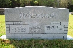
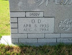
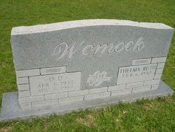
O D Womack
| Birth | : | 6 Apr 1935 Huttig, Union County, Arkansas, USA |
| Death | : | 6 Aug 1994 Huttig, Union County, Arkansas, USA |
| Burial | : | Oheb Shalom Memorial Park, Reisterstown, Baltimore County, USA |
| Coordinate | : | 39.4490013, -76.8368073 |
| Description | : | Husband of Thelma Ruth Sones Womack |
frequently asked questions (FAQ):
-
Where is O D Womack's memorial?
O D Womack's memorial is located at: Oheb Shalom Memorial Park, Reisterstown, Baltimore County, USA.
-
When did O D Womack death?
O D Womack death on 6 Aug 1994 in Huttig, Union County, Arkansas, USA
-
Where are the coordinates of the O D Womack's memorial?
Latitude: 39.4490013
Longitude: -76.8368073
Family Members:
Parent
Spouse
Siblings
Children
Nearby Cemetories:
1. Oheb Shalom Memorial Park
Reisterstown, Baltimore County, USA
Coordinate: 39.4490013, -76.8368073
2. Baltimore Hebrew Cemetery
Reisterstown, Baltimore County, USA
Coordinate: 39.4507828, -76.8328094
3. Reisterstown United Methodist Church Cemetery
Reisterstown, Baltimore County, USA
Coordinate: 39.4621110, -76.8296450
4. Reisterstown Community Cemetery
Reisterstown, Baltimore County, USA
Coordinate: 39.4639400, -76.8308000
5. All Saints Episcopal Church Cemetery
Reisterstown, Baltimore County, USA
Coordinate: 39.4625100, -76.8233200
6. Saint Lukes Cemetery
Reisterstown, Baltimore County, USA
Coordinate: 39.4626900, -76.8210900
7. Nicodemus Memorial Park
Reisterstown, Baltimore County, USA
Coordinate: 39.4480700, -76.8657200
8. Conrad Uhler Family Cemetery
Reisterstown, Baltimore County, USA
Coordinate: 39.4714170, -76.8326930
9. Murray Family Cemetery
Deer Park, Baltimore County, USA
Coordinate: 39.4341800, -76.8622200
10. Deer Park Cemetery
Reisterstown, Baltimore County, USA
Coordinate: 39.4302711, -76.8606873
11. Lowe Family Cemetery
Owings Mills, Baltimore County, USA
Coordinate: 39.4292600, -76.8135900
12. Baseman Family Cemetery
Reisterstown, Baltimore County, USA
Coordinate: 39.4336600, -76.8801620
13. Pleasant Hill United Methodist Church Cemetery
Owings Mills, Baltimore County, USA
Coordinate: 39.4294400, -76.7912700
14. O'Grady Chapel Cemetery
Reisterstown, Baltimore County, USA
Coordinate: 39.4993550, -76.8478630
15. Garrison Forest Veterans Cemetery
Owings Mills, Baltimore County, USA
Coordinate: 39.4407600, -76.7680800
16. Har Sinai Cemetery
Owings Mills, Baltimore County, USA
Coordinate: 39.4353900, -76.7683800
17. Garrison Forest Cemetery
Owings Mills, Baltimore County, USA
Coordinate: 39.4363000, -76.7674800
18. Wards Chapel United Methodist Church Cemetery
Randallstown, Baltimore County, USA
Coordinate: 39.3956500, -76.8633600
19. Mount Paran Presbyterian Church Cemetery
Randallstown, Baltimore County, USA
Coordinate: 39.3911800, -76.8356800
20. Mount Zion United Methodist Church Cemetery
Finksburg, Carroll County, USA
Coordinate: 39.4933014, -76.8882980
21. Bennett Family Cemetery
Eldersburg, Carroll County, USA
Coordinate: 39.4127998, -76.9000015
22. New Oakland Cemetery
Eldersburg, Carroll County, USA
Coordinate: 39.4103012, -76.9017029
23. Rosewood State Hospital Cemetery
Owings Mills, Baltimore County, USA
Coordinate: 39.4215500, -76.7619000
24. Saint Thomas Episcopal Church Cemetery
Owings Mills, Baltimore County, USA
Coordinate: 39.4215500, -76.7619000

