
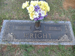
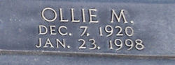
Ollie M. Wright
| Birth | : | 7 Dec 1920 |
| Death | : | 23 Jan 1998 |
| Burial | : | St. Peter's Churchyard, Easton, South Norfolk District, England |
| Coordinate | : | 52.6543660, 1.1478070 |
| Plot | : | Right section |
frequently asked questions (FAQ):
-
Where is Ollie M. Wright's memorial?
Ollie M. Wright's memorial is located at: St. Peter's Churchyard, Easton, South Norfolk District, England.
-
When did Ollie M. Wright death?
Ollie M. Wright death on 23 Jan 1998 in
-
Where are the coordinates of the Ollie M. Wright's memorial?
Latitude: 52.6543660
Longitude: 1.1478070
Family Members:
Children


Nearby Cemetories:
1. St Andrew's Churchyard
Honingham, Broadland District, England
Coordinate: 52.6573170, 1.1244600
2. St. Mary's Churchyard
Marlingford, South Norfolk District, England
Coordinate: 52.6310660, 1.1416800
3. St. Andrew's Churchyard
Colton, South Norfolk District, England
Coordinate: 52.6407700, 1.1089300
4. St. Peter's Churchyard
Ringland, Broadland District, England
Coordinate: 52.6822900, 1.1552400
5. St. Mary and St. Walstan Churchyard
Bawburgh, South Norfolk District, England
Coordinate: 52.6327480, 1.1796530
6. St Botolphs
Barford, South Norfolk District, England
Coordinate: 52.6287000, 1.1118000
7. Costessey Parish Cemetery
Costessey, South Norfolk District, England
Coordinate: 52.6495927, 1.2040157
8. St. Edmund's Churchyard
Taverham, Broadland District, England
Coordinate: 52.6789990, 1.1949460
9. Our Lady & St. Walstan Churchyard
Costessey, South Norfolk District, England
Coordinate: 52.6583200, 1.2119300
10. Costessey Baptist Churchyard
Costessey, South Norfolk District, England
Coordinate: 52.6600122, 1.2116993
11. All Saints Churchyard
East Tuddenham, Breckland Borough, England
Coordinate: 52.6602410, 1.0813620
12. St Mary's and All Saints Churchyard
Little Melton, South Norfolk District, England
Coordinate: 52.6173083, 1.1798046
13. Colney Woodland Burial Park
Colney, South Norfolk District, England
Coordinate: 52.6254580, 1.1991560
14. All Saints & St Mary Churchyard
Great Melton, South Norfolk District, England
Coordinate: 52.6108700, 1.1602200
15. St. Edmund's Churchyard
Costessey, South Norfolk District, England
Coordinate: 52.6660400, 1.2183410
16. St Margaret's Church
Morton on the Hill, Broadland District, England
Coordinate: 52.6987710, 1.1450960
17. St Michael's Church
Bowthorpe, City of Norwich, England
Coordinate: 52.6359300, 1.2163600
18. All Saints Churchyard
Weston Longville, Broadland District, England
Coordinate: 52.6990630, 1.1257670
19. All Saints Churchyard
Weston Longville, Broadland District, England
Coordinate: 52.6993460, 1.1262510
20. St. Peter and St. Paul Churchyard
Barnham Broom, South Norfolk District, England
Coordinate: 52.6281830, 1.0749820
21. St. Margaret's Churchyard
Drayton, Broadland District, England
Coordinate: 52.6773010, 1.2241980
22. St. Andrew Churchyard
Colney, South Norfolk District, England
Coordinate: 52.6253800, 1.2206100
23. St. Andrew's Churchyard
Attlebridge, Broadland District, England
Coordinate: 52.7075040, 1.1504910
24. St. Michael's Churchyard
Hockering, Breckland Borough, England
Coordinate: 52.6771691, 1.0629078