
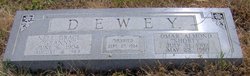
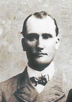
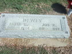
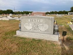
Omar Almond Dewey
| Birth | : | 31 Jul 1902 Trenton, Hitchcock County, Nebraska, USA |
| Death | : | 22 May 1989 Coffeyville, Montgomery County, Kansas, USA |
| Burial | : | Gemeentelijke Begraafplaats Stompwijk, Stompwijk, Leidschendam-Voorburg Municipality, Netherlands |
| Coordinate | : | 52.0952190, 4.4647780 |
| Description | : | ID: I521702749 Name: Omar Almond "Shorty" DEWEY Given Name: Omar Almond "Shorty" Surname: Dewey Sex: M Birth: July 31, 1902 in Trenton, NE Death: May 22, 1989 in Coffeyville, KS MARC: September 27, 1924 Columbus, KS Burial: Lake Creek Cemetery Bartlett, KS |
frequently asked questions (FAQ):
-
Where is Omar Almond Dewey's memorial?
Omar Almond Dewey's memorial is located at: Gemeentelijke Begraafplaats Stompwijk, Stompwijk, Leidschendam-Voorburg Municipality, Netherlands.
-
When did Omar Almond Dewey death?
Omar Almond Dewey death on 22 May 1989 in Coffeyville, Montgomery County, Kansas, USA
-
Where are the coordinates of the Omar Almond Dewey's memorial?
Latitude: 52.0952190
Longitude: 4.4647780
Family Members:
Parent
Spouse
Siblings
Children
Flowers:


Nearby Cemetories:
1. Gemeentelijke Begraafplaats Stompwijk
Stompwijk, Leidschendam-Voorburg Municipality, Netherlands
Coordinate: 52.0952190, 4.4647780
2. Begraafplaats St. Jans Onthoofding
Zuidbuurt, Zoeterwoude Municipality, Netherlands
Coordinate: 52.1091010, 4.5028680
3. Crematorium Meerbloemhof
Zoetermeer Municipality, Netherlands
Coordinate: 52.0668059, 4.4615465
4. Begraafplaats Hoflaan
Zoetermeer, Zoetermeer Municipality, Netherlands
Coordinate: 52.0652820, 4.4638980
5. Nederlands Hervormd Kerkhof Dorpskerk
Voorschoten, Voorschoten Municipality, Netherlands
Coordinate: 52.1251120, 4.4465990
6. Nederlands-Hervormde Begraafplaats Dorpskerk
Zoeterwoude-Dorp, Zoeterwoude Municipality, Netherlands
Coordinate: 52.1212195, 4.4971618
7. Begraafplaats Rosenburgh
Voorschoten, Voorschoten Municipality, Netherlands
Coordinate: 52.1201420, 4.4299620
8. Nederlands Hervormde Begraafplaats Wilsveen
Wilsveen, Leidschendam-Voorburg Municipality, Netherlands
Coordinate: 52.0738933, 4.4222136
9. Rooms Katholiek Kerkhof H. Laurentiuskerk
Voorschoten, Voorschoten Municipality, Netherlands
Coordinate: 52.1299570, 4.4552670
10. Rooms Katholieke Begraafplaats Sint Agatha
Leidschendam, Leidschendam-Voorburg Municipality, Netherlands
Coordinate: 52.0934310, 4.4022130
11. Kerkhof RK Sint Nicolaaskerk
Zoetermeer, Zoetermeer Municipality, Netherlands
Coordinate: 52.0575321, 4.4954131
12. Zoetermeer Old Churchyard
Zoetermeer, Zoetermeer Municipality, Netherlands
Coordinate: 52.0562600, 4.4959300
13. Kerkhof Hervormde Kerk Benthuizen
Benthuizen, Alphen aan den Rijn Municipality, Netherlands
Coordinate: 52.0770000, 4.5407400
14. Begraafplaats Binnenweg
Zoetermeer, Zoetermeer Municipality, Netherlands
Coordinate: 52.0494000, 4.5077000
15. Begraafplaats Vrederust
Benthuizen, Alphen aan den Rijn Municipality, Netherlands
Coordinate: 52.0745097, 4.5441947
16. Wassenaar Joodse Begraafplaats
Wassenaar, Wassenaar Municipality, Netherlands
Coordinate: 52.1116400, 4.3699200
17. Algemene Begraafplaats Hoge Rijndijk
Zoeterwoude-Rijndijk, Zoeterwoude Municipality, Netherlands
Coordinate: 52.1448600, 4.5233400
18. RK Begraafplaats Sint-Bartholomeüskerk
Nootdorp, Pijnacker-Nootdorp Municipality, Netherlands
Coordinate: 52.0491000, 4.3941100
19. Dierenbegraafplaats Groenendijk
Groenendijk, Alphen aan den Rijn Municipality, Netherlands
Coordinate: 52.1284310, 4.5529946
20. Rooms Katholieke Begraafplaats Sint Willibrordus
Wassenaar, Wassenaar Municipality, Netherlands
Coordinate: 52.1399480, 4.3906280
21. Pieterskerk
Leiden, Leiden Municipality, Netherlands
Coordinate: 52.1576200, 4.4877290
22. Hooglandse Kerk
Leiden, Leiden Municipality, Netherlands
Coordinate: 52.1579230, 4.4938010
23. Dorpskerk Leiderdorp
Leiderdorp, Leiderdorp Municipality, Netherlands
Coordinate: 52.1509480, 4.5234880
24. Begraafplaats Groenesteeg
Leiden, Leiden Municipality, Netherlands
Coordinate: 52.1573700, 4.5029200