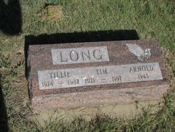
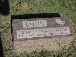
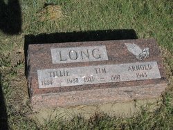
Orville Arnold “Tim” Long
| Birth | : | 12 May 1921 Philip, Haakon County, South Dakota, USA |
| Death | : | 17 May 1997 Lovington, Lea County, New Mexico, USA |
| Burial | : | Calvary Cemetery, Dayton, Montgomery County, USA |
| Coordinate | : | 39.7248993, -84.1979980 |
| Description | : | From The Rapid City Journal (Rapid City, South Dakota) Sunday, May 18, 1997, Page 24: Orville "Tim" Long LOVINGTON, N.M. - Orville "Tim" Long, 76, Lovington and formerly of Philip, S.D., died Saturday, May 17, 1997, at Nor-Lea General Hospital in Lovington. Survivors include his wife, Clara Long, Lovington; two daughters, Sally Campbell, Saukville, Wis., and Linda Kramer, Moore Park, Calif.; four stepsons, Tony Hemmingson, Lovington, Loren Hemmingson, Eunice, David Hemmingson, Philip, S.D., and Arnie Hemmingson, Spearfish, S.D.; one stepdaughter, Jeanette Ernest, Bellville, Ill.; three brothers, Leroy Long, Philip, S.D., Al Long, Rapid City, S.D., and Bob Long,... Read More |
frequently asked questions (FAQ):
-
Where is Orville Arnold “Tim” Long's memorial?
Orville Arnold “Tim” Long's memorial is located at: Calvary Cemetery, Dayton, Montgomery County, USA.
-
When did Orville Arnold “Tim” Long death?
Orville Arnold “Tim” Long death on 17 May 1997 in Lovington, Lea County, New Mexico, USA
-
Where are the coordinates of the Orville Arnold “Tim” Long's memorial?
Latitude: 39.7248993
Longitude: -84.1979980
Family Members:
Parent
Spouse
Siblings
Children
Flowers:
Nearby Cemetories:
1. Calvary Cemetery
Dayton, Montgomery County, USA
Coordinate: 39.7248993, -84.1979980
2. Beth Abraham Cemetery
Oakwood, Montgomery County, USA
Coordinate: 39.7291985, -84.1919022
3. Riverview Cemetery
Dayton, Montgomery County, USA
Coordinate: 39.7299995, -84.1908035
4. Old Greencastle Cemetery
Dayton, Montgomery County, USA
Coordinate: 39.7370000, -84.2143900
5. Saint Paul's Episcopal Church Columbarium
Oakwood, Montgomery County, USA
Coordinate: 39.7249780, -84.1747480
6. Saint Henrys Cemetery
Dayton, Montgomery County, USA
Coordinate: 39.7450150, -84.1887630
7. Marianist Brothers Cemetery
Dayton, Montgomery County, USA
Coordinate: 39.7385700, -84.1733500
8. Woodland Cemetery and Arboretum
Dayton, Montgomery County, USA
Coordinate: 39.7428840, -84.1773210
9. New Greencastle Cemetery
Dayton, Montgomery County, USA
Coordinate: 39.7346992, -84.2272034
10. Dayton Presbyterian and Methodist Graveyard (Defun
Dayton, Montgomery County, USA
Coordinate: 39.7558670, -84.1933820
11. Zion Cemetery
Moraine, Montgomery County, USA
Coordinate: 39.6931877, -84.2118378
12. Westmont Cemetery
Dayton, Montgomery County, USA
Coordinate: 39.7247009, -84.2453003
13. Christ Episcopal Church Columbarium
Dayton, Montgomery County, USA
Coordinate: 39.7620240, -84.1937090
14. Kinsey-Wolf Family Cemetery
Dayton, Montgomery County, USA
Coordinate: 39.7405220, -84.2540900
15. Davids Cemetery
Kettering, Montgomery County, USA
Coordinate: 39.6789017, -84.1697006
16. Kaylor Family Cemetery
Frytown, Montgomery County, USA
Coordinate: 39.7086110, -84.2616670
17. Dayton National Cemetery
Dayton, Montgomery County, USA
Coordinate: 39.7482224, -84.2591705
18. Beavertown Cemetery
Beavertown, Montgomery County, USA
Coordinate: 39.6981010, -84.1288986
19. Lower Miami Cemetery
Dayton, Montgomery County, USA
Coordinate: 39.7121124, -84.2772903
20. Saint Georges Episcopal Church Memorial Garden
Dayton, Montgomery County, USA
Coordinate: 39.6672760, -84.1608950
21. County Infirmary Cemetery
Drexel, Montgomery County, USA
Coordinate: 39.7383900, -84.2827200
22. Evergreen Cemetery
West Carrollton City, Montgomery County, USA
Coordinate: 39.6744003, -84.2585983
23. Woodbourne Cemetery
Montgomery County, USA
Coordinate: 39.6588783, -84.1727676
24. Munger Road Cemetery
Centerville, Montgomery County, USA
Coordinate: 39.6556220, -84.2048980

