
Osie Freida Tate Griswold
| Birth | : | 3 May 1917 Norton, Norton County, Kansas, USA |
| Death | : | 9 Sep 1990 Hydesville, Humboldt County, California, USA |
| Burial | : | Oak Hill Cemetery, Red Bluff, Tehama County, USA |
| Coordinate | : | 40.1699982, -122.2433014 |
| Plot | : | Sec. K-5-28, No marker |
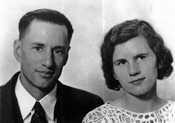
| Description | : | Osie was a red haired Irish girl from Kansas who had been adopted by her aunt and uncle, Earl and Lula Swope. She moved with her family to Tehama County in the wake of the dust bowl. She met Frank Griswold and they married when she finished high school. Frank was raising Angora goats with his brothers in the foothills of Tehama Co, but after WWII, they moved to Humboldt Co where Frank worked in the lumber mills. They were blessed with six children: Bobby, Ethel, Jimmy, Donald, Norma Jean and Virginia. |
frequently asked questions (FAQ):
-
Where is Osie Freida Tate Griswold's memorial?
Osie Freida Tate Griswold's memorial is located at: Oak Hill Cemetery, Red Bluff, Tehama County, USA.
-
When did Osie Freida Tate Griswold death?
Osie Freida Tate Griswold death on 9 Sep 1990 in Hydesville, Humboldt County, California, USA
-
Where are the coordinates of the Osie Freida Tate Griswold's memorial?
Latitude: 40.1699982
Longitude: -122.2433014
Family Members:
Parent
Spouse
Flowers:


Nearby Cemetories:
1. Red Bluff Memorial Chapel Mausoleum & Columbarium
Red Bluff, Tehama County, USA
Coordinate: 40.1717130, -122.2466860
2. Saint Mary's Cemetery
Red Bluff, Tehama County, USA
Coordinate: 40.1716995, -122.2521973
3. Growney Ranch Family Cemetery
Red Bluff, Tehama County, USA
Coordinate: 40.1167300, -122.1952500
4. Los Molinos Cemetery
Los Molinos, Tehama County, USA
Coordinate: 40.0475650, -122.1011820
5. Tehama Cemetery
Tehama, Tehama County, USA
Coordinate: 40.0233002, -122.1433029
6. Red Bank Cemetery
Red Bank, Tehama County, USA
Coordinate: 40.1036970, -122.4458540
7. Inks Creek Cemetery
Tehama County, USA
Coordinate: 40.3419800, -122.1297100
8. Cottonwood Creek Ranch Cemetery
Cottonwood, Shasta County, USA
Coordinate: 40.3663100, -122.2598800
9. Cottonwood Cemetery
Cottonwood, Shasta County, USA
Coordinate: 40.3856100, -122.2936500
10. Major Pierson B Reading Family Cemetery
Cottonwood, Shasta County, USA
Coordinate: 40.3924300, -122.2126900
11. Sunset Hill Cemetery
Corning, Tehama County, USA
Coordinate: 39.9271600, -122.1586100
12. Sleepy Hollow Pet Cemetery
Anderson, Shasta County, USA
Coordinate: 40.4199430, -122.2858410
13. Rosewood Cemetery
Rosewood, Tehama County, USA
Coordinate: 40.2685360, -122.5575190
14. New Clairvaux Abbey Cemetery
Vina, Tehama County, USA
Coordinate: 39.9381450, -122.0641890
15. Anderson District Cemetery
Anderson, Shasta County, USA
Coordinate: 40.4419518, -122.2967300
16. Oddfellows Cemetery
Anderson, Shasta County, USA
Coordinate: 40.4431590, -122.2907070
17. Anderson Pioneer Cemetery
Anderson, Shasta County, USA
Coordinate: 40.4439011, -122.2904968
18. Vina Cemetery
Vina, Tehama County, USA
Coordinate: 39.9636440, -121.9957070
19. Lowrey Cemetery
Tehama County, USA
Coordinate: 40.0066986, -122.5635986
20. Cameron-Davis Cemetery
Tehama County, USA
Coordinate: 40.2709800, -121.8778500
21. Parkville Cemetery
Anderson, Shasta County, USA
Coordinate: 40.4640200, -122.1897500
22. Lanes Valley Cemetery
Paynes Creek, Tehama County, USA
Coordinate: 40.3998400, -121.9762400
23. Pinckney Cemetery
Cottonwood, Shasta County, USA
Coordinate: 40.3997002, -122.5180969
24. Kirkwood Cemetery
Corning, Tehama County, USA
Coordinate: 39.8624992, -122.1519012