
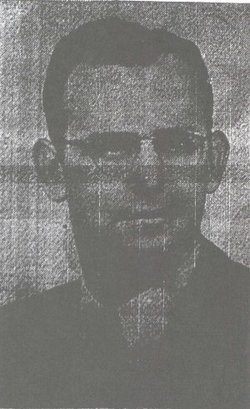
Otis Aleric Henderson
| Birth | : | 10 Jan 1930 Chelan, Chelan County, Washington, USA |
| Death | : | 19 Aug 2001 Chelan, Chelan County, Washington, USA |
| Burial | : | Chelan Fraternal Cemetery, Chelan, Chelan County, USA |
| Coordinate | : | 47.8502998, -120.0081024 |
| Plot | : | South Fraternal Row34 STBLK36 LN3 |
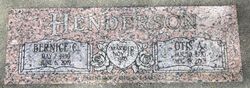
| Inscription | : | MARRIED NOV. 23, 1950 - parents of Otis C. & Sari C. |
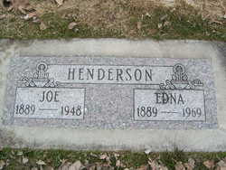
| Description | : | Otis Aleric Henderson - Posted August 22, 2001 Chelan Otis Aleric Henderson, 71, a lifelong resident of Chelan, died Sunday morning, Aug. 19, 2001, at his home following a brief illness. He was born Jan. 10, 1930, at Chelan, the son of Joe and Edna (Fenno) Henderson. He attended schools in the Boyd District and was graduated from Chelan High School in 1948. On Nov. 23, 1950, he was married to Bernice Curran at Chelan. Mr. Henderson was graduated from Whitman College in 1953, with a degree in business administration and economics. Later,... Read More |
frequently asked questions (FAQ):
-
Where is Otis Aleric Henderson's memorial?
Otis Aleric Henderson's memorial is located at: Chelan Fraternal Cemetery, Chelan, Chelan County, USA.
-
When did Otis Aleric Henderson death?
Otis Aleric Henderson death on 19 Aug 2001 in Chelan, Chelan County, Washington, USA
-
Where are the coordinates of the Otis Aleric Henderson's memorial?
Latitude: 47.8502998
Longitude: -120.0081024
Family Members:
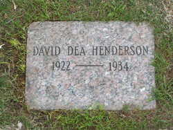
Parent

Spouse
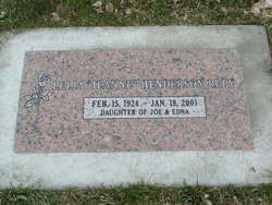
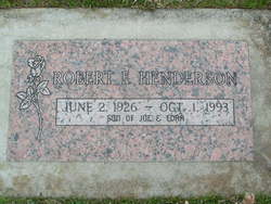
Siblings
Flowers:


Nearby Cemetories:
1. Chelan Fraternal Cemetery
Chelan, Chelan County, USA
Coordinate: 47.8502998, -120.0081024
2. Mount Olivet Cemetery
Chelan, Chelan County, USA
Coordinate: 47.8451000, -119.9946000
3. Saint Andrews Episcopal Church
Chelan, Chelan County, USA
Coordinate: 47.8397460, -120.0183780
4. Riverview Cemetery
Chelan, Chelan County, USA
Coordinate: 47.8335991, -119.9944000
5. Manson Indian Cemetery
Manson, Chelan County, USA
Coordinate: 47.8800000, -120.1300000
6. Ballard Family Cemetery
Stayman, Chelan County, USA
Coordinate: 47.7811100, -120.1133300
7. Fletcher Cemetery
Douglas County, USA
Coordinate: 47.7430992, -119.9403000
8. Brays Landing Cemetery
Douglas County, USA
Coordinate: 47.7364120, -120.1704660
9. Kummer Cemetery
Waterville, Douglas County, USA
Coordinate: 47.6559000, -120.0332000
10. Packwood Memorial Cemetery
Dyer, Douglas County, USA
Coordinate: 48.0118305, -119.8178880
11. Dick Family Cemetery
Okanogan County, USA
Coordinate: 48.0502700, -119.9241700
12. Miller Family Cemetery
Okanogan County, USA
Coordinate: 48.0530300, -119.9288000
13. Pateros Cemetery
Pateros, Okanogan County, USA
Coordinate: 48.0516600, -119.9097300
14. Waterville Cemetery
Waterville, Douglas County, USA
Coordinate: 47.6418500, -120.0685940
15. Gate of Heaven Catholic Cemetery
Waterville, Douglas County, USA
Coordinate: 47.6382100, -120.0671690
16. Douglas Lutheran Cemetery
Douglas County, USA
Coordinate: 47.6189003, -119.9614029
17. Badger Mountain View Cemetery
Douglas County, USA
Coordinate: 47.6088000, -120.0476000
18. Mansfield Cemetery
Mansfield, Douglas County, USA
Coordinate: 47.8088880, -119.6508330
19. Orondo Community Cemetery
Orondo, Douglas County, USA
Coordinate: 47.6486015, -120.2136002
20. Buckingham Cemetery
Douglas County, USA
Coordinate: 47.8669014, -119.6286011
21. Happy Home Cemetery
Farmer, Douglas County, USA
Coordinate: 47.6268997, -119.8125000
22. Methow Cemetery
Methow, Okanogan County, USA
Coordinate: 48.1102982, -120.0124969
23. Entiat Cemetery
Entiat, Chelan County, USA
Coordinate: 47.6755981, -120.3043976
24. Bridgeport Cemetery
Bridgeport, Douglas County, USA
Coordinate: 48.0050000, -119.6738800