
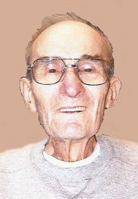


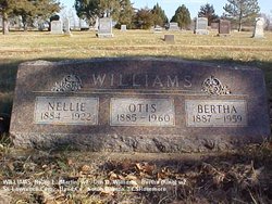
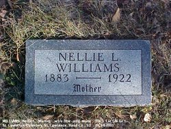
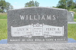
Percy E Williams
| Birth | : | 28 Oct 1916 Saint Lawrence, Hand County, South Dakota, USA |
| Death | : | 6 Mar 2007 Miller, Hand County, South Dakota, USA |
| Burial | : | St. Oswald's Churchyard, Leathley, Harrogate Borough, England |
| Coordinate | : | 53.9187140, -1.6484470 |
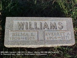
| Description | : | Percy Williams, 90, of Miller, S.D., died Tuesday, March 6, 2007 at Prairie Good Samaritan Center in Miller. Funeral services were held Friday, March 9 at Reck Funeral Home with the Rev. Brian Jones officiating. Burial was in the St. Lawrence Cemetery. Percy Williams was born October 28, 1916 in St. Lawrence to Otis and Nellie (Martin) Williams. He lived around the St. Lawrence and Miller area all of his life. On February 29, 1940, he married Lily Marshall in Huron. Throughout most of their married life, they lived on a farm thirteen miles north of Miller. He was a member of... Read More |
frequently asked questions (FAQ):
-
Where is Percy E Williams's memorial?
Percy E Williams's memorial is located at: St. Oswald's Churchyard, Leathley, Harrogate Borough, England.
-
When did Percy E Williams death?
Percy E Williams death on 6 Mar 2007 in Miller, Hand County, South Dakota, USA
-
Where are the coordinates of the Percy E Williams's memorial?
Latitude: 53.9187140
Longitude: -1.6484470
Family Members:
Parent
Spouse
Siblings

Flowers:


Nearby Cemetories:
1. St. Oswald's Churchyard
Leathley, Harrogate Borough, England
Coordinate: 53.9187140, -1.6484470
2. St Mary Churchyard
Stainburn, Harrogate Borough, England
Coordinate: 53.9323270, -1.6251840
3. All Saints Churchyard
Farnley, Harrogate Borough, England
Coordinate: 53.9281640, -1.6771760
4. St Wilfrid Churchyard
Pool in Wharfdale, Metropolitan Borough of Leeds, England
Coordinate: 53.9023800, -1.6296080
5. Otley Cemetery
Otley, Metropolitan Borough of Leeds, England
Coordinate: 53.9074820, -1.6833890
6. Otley Methodist Church War Memorial
Otley, Metropolitan Borough of Leeds, England
Coordinate: 53.9057130, -1.6906820
7. Salem Independent Congregational Chapelyard
Otley, Metropolitan Borough of Leeds, England
Coordinate: 53.9073370, -1.6939380
8. Our Lady and All Saints Catholic Church
Otley, Metropolitan Borough of Leeds, England
Coordinate: 53.9070200, -1.6940970
9. Otley War Memorial
Otley, Metropolitan Borough of Leeds, England
Coordinate: 53.9041280, -1.6925650
10. All Saints Churchyard
Otley, Metropolitan Borough of Leeds, England
Coordinate: 53.9040570, -1.6946780
11. Puritan Chapelyard
Bramhope, Metropolitan Borough of Leeds, England
Coordinate: 53.8878420, -1.6227120
12. St Giles Churchyard
Bramhope, Metropolitan Borough of Leeds, England
Coordinate: 53.8865500, -1.6226490
13. Bramhope Cemetery
Bramhope, Metropolitan Borough of Leeds, England
Coordinate: 53.8779000, -1.6242700
14. St Peter Churchyard
Arthington, Metropolitan Borough of Leeds, England
Coordinate: 53.8976710, -1.5812530
15. St Barnabas Churchyard
Weeton, Harrogate Borough, England
Coordinate: 53.9140390, -1.5691310
16. St John the Evangelist Churchyard
North Rigton, Harrogate Borough, England
Coordinate: 53.9374290, -1.5747190
17. All Saints Churchyard
Weston, Harrogate Borough, England
Coordinate: 53.9155840, -1.7318030
18. Yeadon Cemetery
Yeadon, Metropolitan Borough of Leeds, England
Coordinate: 53.8716080, -1.6751690
19. Guiseley Cemetery
Guiseley, Metropolitan Borough of Leeds, England
Coordinate: 53.8846820, -1.7192470
20. St Mary Churchyard
Burley-in-Wharfedale, Metropolitan Borough of Bradford, England
Coordinate: 53.9124040, -1.7415660
21. St. Oswald's Churchyard
Guiseley, Metropolitan Borough of Leeds, England
Coordinate: 53.8751330, -1.7062080
22. Friends Burial Ground at Asquith
Askwith, Harrogate Borough, England
Coordinate: 53.9272670, -1.7419150
23. God's Acre Cemetery
Burley-in-Wharfedale, Metropolitan Borough of Bradford, England
Coordinate: 53.8996500, -1.7393000
24. High Royds Memorial Garden
Menston, Metropolitan Borough of Bradford, England
Coordinate: 53.8866100, -1.7283200