
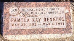

Pamela Kay Henning
| Birth | : | 22 May 1953 Lynch, Boyd County, Nebraska, USA |
| Death | : | 6 Mar 1971 Plattsmouth, Cass County, Nebraska, USA |
| Burial | : | Glasco Cemetery, Glasco, Cloud County, USA |
| Coordinate | : | 39.3574000, -97.8265000 |
| Description | : | Glasco Sun, March 11, 1971, page 1: Car-Train Crash Fatal Saturday Funeral services were held at St. Paul's Lutheran Church, Glasco, Wednesday at 10:00 a.m. for Pamela Kay Henning, 17, of Plattsmouth, Nebr. Pastor Wendell Berggren officiated. Pamela died Saturday after a car-train collision in Nebraska. She is the daughter of Rev. Wilfred Henning, formerly of Glasco, and Mrs. Henning, the former Barbara Morris of Salina. Pamela was a senior at Plattsmouth high school. She was a member of Christ Lutheran Church, Louisville, Nebr., where her father is pastor. Also surviving are three brothers, Jeoffrey, Timothy, and Mark, and three sisters, Christine, Melanie and... Read More |
frequently asked questions (FAQ):
-
Where is Pamela Kay Henning's memorial?
Pamela Kay Henning's memorial is located at: Glasco Cemetery, Glasco, Cloud County, USA.
-
When did Pamela Kay Henning death?
Pamela Kay Henning death on 6 Mar 1971 in Plattsmouth, Cass County, Nebraska, USA
-
Where are the coordinates of the Pamela Kay Henning's memorial?
Latitude: 39.3574000
Longitude: -97.8265000
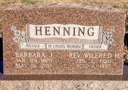
Family Members:
Parent

Siblings

Flowers:


Nearby Cemetories:
1. Glasco Cemetery
Glasco, Cloud County, USA
Coordinate: 39.3574000, -97.8265000
2. Saint Marys Catholic Cemetery
Glasco, Cloud County, USA
Coordinate: 39.3574000, -97.8245000
3. Simpson Cemetery
Simpson, Mitchell County, USA
Coordinate: 39.3633003, -97.9471970
4. Bethel Cemetery
Meredith Township, Cloud County, USA
Coordinate: 39.3506000, -97.7029000
5. Delphos Cemetery
Delphos, Ottawa County, USA
Coordinate: 39.2778015, -97.7416992
6. Saint Paul Cemetery
Delphos, Ottawa County, USA
Coordinate: 39.2677994, -97.7518997
7. Asherville Cemetery
Asherville, Mitchell County, USA
Coordinate: 39.4205000, -97.9672900
8. Morrison Cemetery
Center Township, Cloud County, USA
Coordinate: 39.4817009, -97.7975006
9. Summit Cemetery
Jamestown, Cloud County, USA
Coordinate: 39.4813200, -97.8628800
10. Green Mound Cemetery
Asherville, Mitchell County, USA
Coordinate: 39.3203011, -97.9858017
11. Coursen Grove Cemetery
Simpson, Mitchell County, USA
Coordinate: 39.3060989, -97.9792023
12. Hall Cemetery
Cloud County, USA
Coordinate: 39.4455986, -97.7033005
13. Saint Peters Cemetery
Miltonvale, Cloud County, USA
Coordinate: 39.3652350, -97.6483570
14. Bell-Bogardus Cemetery
Asherville, Mitchell County, USA
Coordinate: 39.4242410, -97.9919970
15. Bohemian National Cemetery
Ada, Ottawa County, USA
Coordinate: 39.2193870, -97.9054030
16. Wilcox Cemetery
Cloud County, USA
Coordinate: 39.4925003, -97.7313995
17. West Asher Cemetery
Scottsville, Mitchell County, USA
Coordinate: 39.4815000, -97.9661600
18. Baldwin Cemetery
Ottawa County, USA
Coordinate: 39.2061005, -97.9111023
19. Kindel Cemetery
Center Township, Cloud County, USA
Coordinate: 39.4519005, -97.6464005
20. Smith Cemetery
Asherville, Mitchell County, USA
Coordinate: 39.4516690, -98.0098850
21. McBride Cemetery
Beloit, Mitchell County, USA
Coordinate: 39.4808006, -97.9907990
22. Enterprise Cemetery
Cloud County, USA
Coordinate: 39.4230995, -97.6106033
23. Shiloh Cemetery
Beloit, Mitchell County, USA
Coordinate: 39.3574982, -98.0594025
24. Summit Cemetery #3
Macyville, Cloud County, USA
Coordinate: 39.5258330, -97.9194440