
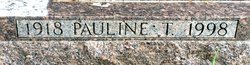
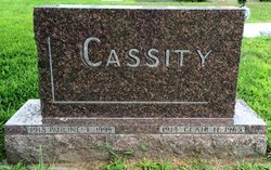
Pauline Elizabeth “Polly” Thompson Cassity
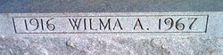
| Birth | : | 15 Mar 1918 |
| Death | : | 22 Mar 1998 |
| Burial | : | Mount Hope Cemetery, Clyde, Cloud County, USA |
| Coordinate | : | 39.5969009, -97.4116974 |
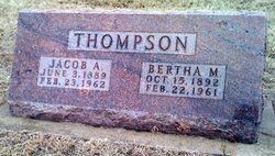
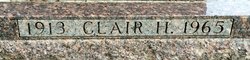
| Description | : | OBITUARY: Register Star Thursday, Mar 26, 1998 Rockford, IL Page:15 Pauline “Polly” Cassity, 80 Pauline “Polly” Cassity, 80, of Rockford, died at 5:10 p.m. Sunday, March 22, 1998 in Swedish American Hospital after a short illness. Born March 15, 1918 in Mankato, Kan., daughter of Jacob and Bertha May Scott Thompson. Rockford resident since 1947. Married Clair Cassity in Clyde, Kan., on Aug. 31, 1847; he died Aug. 6, 1965. She received a Bachelor of Science degree from Rockford College and was an elementary teacher in Rockford for more than 20 years, retiring in 1978. Member... Read More |
frequently asked questions (FAQ):
-
Where is Pauline Elizabeth “Polly” Thompson Cassity's memorial?
Pauline Elizabeth “Polly” Thompson Cassity's memorial is located at: Mount Hope Cemetery, Clyde, Cloud County, USA.
-
When did Pauline Elizabeth “Polly” Thompson Cassity death?
Pauline Elizabeth “Polly” Thompson Cassity death on 22 Mar 1998 in
-
Where are the coordinates of the Pauline Elizabeth “Polly” Thompson Cassity's memorial?
Latitude: 39.5969009
Longitude: -97.4116974
Family Members:
Parent

Spouse
Siblings

Flowers:


Nearby Cemetories:
1. Mount Calvary Cemetery
Clyde, Cloud County, USA
Coordinate: 39.5917015, -97.4143982
2. Cedar Grove Cemetery
Clyde, Cloud County, USA
Coordinate: 39.5494003, -97.4056015
3. Pleasant View Cemetery
Ames, Cloud County, USA
Coordinate: 39.5346985, -97.4431000
4. Walnut Grove Cemetery
Cloud County, USA
Coordinate: 39.5699997, -97.4993973
5. Agenda Cemetery
Agenda, Republic County, USA
Coordinate: 39.6761017, -97.4336014
6. Saint Joseph Cemetery
Saint Joseph, Cloud County, USA
Coordinate: 39.5074941, -97.4022328
7. Beck Family Cemetery
Agenda, Republic County, USA
Coordinate: 39.6818000, -97.4863000
8. Green Mound Cemetery
Rice, Cloud County, USA
Coordinate: 39.5248450, -97.5081630
9. Hollis Cemetery
Cloud County, USA
Coordinate: 39.6383018, -97.5361023
10. Rice Cemetery
Rice, Cloud County, USA
Coordinate: 39.5614014, -97.5552979
11. Nelson Cemetery
Rice, Cloud County, USA
Coordinate: 39.5257988, -97.5410995
12. Riverdale Cemetery
Clay County, USA
Coordinate: 39.5106010, -97.2930984
13. Willoughby Cemetery
Agenda, Republic County, USA
Coordinate: 39.7402992, -97.4244003
14. Union Cemetery
Wayne, Republic County, USA
Coordinate: 39.6977997, -97.5457993
15. Saint Peters Cemetery
Aurora, Cloud County, USA
Coordinate: 39.4763985, -97.5180969
16. Princeville Cemetery
Aurora, Cloud County, USA
Coordinate: 39.4672012, -97.5010986
17. Iwacura Cemetery
Morganville, Clay County, USA
Coordinate: 39.4550000, -97.3510000
18. Gotland Cemetery
Sibley Township, Cloud County, USA
Coordinate: 39.6091995, -97.6125031
19. French Presbyterian Church Cemetery
Cloud County, USA
Coordinate: 39.4395200, -97.4148290
20. Sherman Cemetery
Morganville, Clay County, USA
Coordinate: 39.5316300, -97.2243700
21. Zion Cemetery
Agenda, Republic County, USA
Coordinate: 39.6749992, -97.5939026
22. Rose Hill Cemetery
Wayne, Republic County, USA
Coordinate: 39.7111015, -97.5661011
23. Minersville Cemetery
Talmo, Republic County, USA
Coordinate: 39.6568330, -97.6229250
24. Bloom Cemetery
Morganville, Clay County, USA
Coordinate: 39.4519005, -97.2778015