
| Birth | : | 23 Oct 1942 Clyde, Cloud County, Kansas, USA |
| Death | : | 15 Mar 2009 Concordia, Cloud County, Kansas, USA |
| Burial | : | Mount Calvary Cemetery, Clyde, Cloud County, USA |
| Coordinate | : | 39.5917015, -97.4143982 |
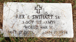
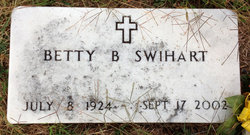
| Description | : | Pauline E. Cyr Pauline Elizabeth Cyr, 66 of Clyde, died March 15, 2009 at Cloud County Health Center, Concordia, KS. She was born October 23, 1942 in Clyde to Rex and Betty (Boling) Swihart, Sr. Pauline married Gail Cyr on June 1, 1968 in Belleville, KS. She worked as assistant Librarian at the Randolph-Decker Library in Clyde for over 16 years. She was a member of the St. John the Baptist church, Clyde and the women's Auxiliary for VFW Post 7515, Clyde. Survivors include her daughters, Claudelle Wedel and husband Dave of Lyons, KS, Terry Chartier and... Read More |
frequently asked questions (FAQ):
-
Where is Pauline Elizabeth Swihart Cyr's memorial?
Pauline Elizabeth Swihart Cyr's memorial is located at: Mount Calvary Cemetery, Clyde, Cloud County, USA.
-
When did Pauline Elizabeth Swihart Cyr death?
Pauline Elizabeth Swihart Cyr death on 15 Mar 2009 in Concordia, Cloud County, Kansas, USA
-
Where are the coordinates of the Pauline Elizabeth Swihart Cyr's memorial?
Latitude: 39.5917015
Longitude: -97.4143982
Family Members:
Parent
Spouse

Siblings
Children
Flowers:


Nearby Cemetories:
1. Mount Calvary Cemetery
Clyde, Cloud County, USA
Coordinate: 39.5917015, -97.4143982
2. Mount Hope Cemetery
Clyde, Cloud County, USA
Coordinate: 39.5969009, -97.4116974
3. Cedar Grove Cemetery
Clyde, Cloud County, USA
Coordinate: 39.5494003, -97.4056015
4. Pleasant View Cemetery
Ames, Cloud County, USA
Coordinate: 39.5346985, -97.4431000
5. Walnut Grove Cemetery
Cloud County, USA
Coordinate: 39.5699997, -97.4993973
6. Saint Joseph Cemetery
Saint Joseph, Cloud County, USA
Coordinate: 39.5074941, -97.4022328
7. Agenda Cemetery
Agenda, Republic County, USA
Coordinate: 39.6761017, -97.4336014
8. Green Mound Cemetery
Rice, Cloud County, USA
Coordinate: 39.5248450, -97.5081630
9. Hollis Cemetery
Cloud County, USA
Coordinate: 39.6383018, -97.5361023
10. Beck Family Cemetery
Agenda, Republic County, USA
Coordinate: 39.6818000, -97.4863000
11. Rice Cemetery
Rice, Cloud County, USA
Coordinate: 39.5614014, -97.5552979
12. Nelson Cemetery
Rice, Cloud County, USA
Coordinate: 39.5257988, -97.5410995
13. Riverdale Cemetery
Clay County, USA
Coordinate: 39.5106010, -97.2930984
14. Saint Peters Cemetery
Aurora, Cloud County, USA
Coordinate: 39.4763985, -97.5180969
15. Princeville Cemetery
Aurora, Cloud County, USA
Coordinate: 39.4672012, -97.5010986
16. Iwacura Cemetery
Morganville, Clay County, USA
Coordinate: 39.4550000, -97.3510000
17. Union Cemetery
Wayne, Republic County, USA
Coordinate: 39.6977997, -97.5457993
18. Willoughby Cemetery
Agenda, Republic County, USA
Coordinate: 39.7402992, -97.4244003
19. French Presbyterian Church Cemetery
Cloud County, USA
Coordinate: 39.4395200, -97.4148290
20. Gotland Cemetery
Sibley Township, Cloud County, USA
Coordinate: 39.6091995, -97.6125031
21. Sherman Cemetery
Morganville, Clay County, USA
Coordinate: 39.5316300, -97.2243700
22. Zion Cemetery
Agenda, Republic County, USA
Coordinate: 39.6749992, -97.5939026
23. Rose Hill Cemetery
Wayne, Republic County, USA
Coordinate: 39.7111015, -97.5661011
24. Minersville Cemetery
Talmo, Republic County, USA
Coordinate: 39.6568330, -97.6229250