
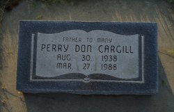
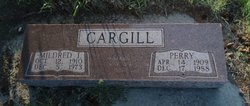
Perry "Don" Cargill
| Birth | : | 30 Aug 1938 Greeley, Greeley County, Nebraska, USA |
| Death | : | 27 Mar 1988 Omaha, Douglas County, Nebraska, USA |
| Burial | : | Atlantic County Veterans Cemetery, Estell Manor, Atlantic County, USA |
| Coordinate | : | 39.3882790, -74.7386017 |
| Description | : | Don Cargill Funeral Services were held 10:30 A.M., Wednesday, March 30, 1988 at St. John's Lutheran Church at Kronborg. Interment was held in the Mt. Hope Cemetery in Scotia, Nebraska. OBITUARY: Don Cargill Perry Don Cargill, the son of Perry and Mildred (Mohler) Cargill, was born at Greely, Nebraska, on August 30, 1938, and passed away at Omaha, Nebraska, on March 27, 1988, at the age of 49 years, 6 months, and 27 days. He received his early education at rural grade school, and graduated from Scotia High School, and attended Kearney State College. He loved family, farming and cattle, and... Read More |
frequently asked questions (FAQ):
-
Where is Perry "Don" Cargill's memorial?
Perry "Don" Cargill's memorial is located at: Atlantic County Veterans Cemetery, Estell Manor, Atlantic County, USA.
-
When did Perry "Don" Cargill death?
Perry "Don" Cargill death on 27 Mar 1988 in Omaha, Douglas County, Nebraska, USA
-
Where are the coordinates of the Perry "Don" Cargill's memorial?
Latitude: 39.3882790
Longitude: -74.7386017
Family Members:
Parent

Spouse
Flowers:


Nearby Cemetories:
1. Atlantic County Veterans Cemetery
Estell Manor, Atlantic County, USA
Coordinate: 39.3882790, -74.7386017
2. Steelmans Creek Burial Ground
Estell Manor, Atlantic County, USA
Coordinate: 39.3878517, -74.7388687
3. Estellville Methodist Church Cemetery
Mays Landing, Atlantic County, USA
Coordinate: 39.3976900, -74.7477700
4. Methodist Burying Ground
Estellville, Atlantic County, USA
Coordinate: 39.3978615, -74.7480164
5. Old Burying Ground
Estellville, Atlantic County, USA
Coordinate: 39.3959680, -74.7518810
6. Smith-Ireland Burying Ground
Estellville, Atlantic County, USA
Coordinate: 39.4151800, -74.7329640
7. Catawba Church and Burying Ground
Atlantic County, USA
Coordinate: 39.4082794, -74.7136078
8. Union Cemetery
Mays Landing, Atlantic County, USA
Coordinate: 39.4373894, -74.7080536
9. Asbury Methodist Episcopal Church Cemetery
English Creek, Atlantic County, USA
Coordinate: 39.3621483, -74.6706314
10. Westcott Free Burying Ground
Mays Landing, Atlantic County, USA
Coordinate: 39.4526215, -74.7281189
11. Presbyterian Cemetery
Mays Landing, Atlantic County, USA
Coordinate: 39.4539185, -74.7269821
12. Bethlehem Evangelical Lutheran Cemetery
Dorothy, Atlantic County, USA
Coordinate: 39.4056396, -74.8247070
13. Estell Manor Community Church Cemetery
Estell Manor, Atlantic County, USA
Coordinate: 39.3763160, -74.8270490
14. Saint Bernard Clairvaux Roman Catholic Cemetery
Dorothy, Atlantic County, USA
Coordinate: 39.4073067, -74.8260803
15. Lincoln Memorial Park
Mays Landing, Atlantic County, USA
Coordinate: 39.4478493, -74.6872635
16. Palestine Bible Protestant Church Cemetery
Scullville, Atlantic County, USA
Coordinate: 39.3487091, -74.6608810
17. Holy Cross Cemetery and Chapel Mausoleum
Mays Landing, Atlantic County, USA
Coordinate: 39.4490395, -74.6839523
18. Carmantown Cemetery
Carmantown, Atlantic County, USA
Coordinate: 39.4483250, -74.6446000
19. Tuckahoe United Methodist Church Cemetery
Tuckahoe, Cape May County, USA
Coordinate: 39.2921500, -74.7546600
20. Head of the River Cemetery
Estell Manor, Atlantic County, USA
Coordinate: 39.3098259, -74.8210449
21. Zion Cemetery
Bargaintown, Atlantic County, USA
Coordinate: 39.3661390, -74.5885100
22. Zion United Methodist Church Cemetery
Egg Harbor Township, Atlantic County, USA
Coordinate: 39.3674200, -74.5880000
23. Old Weymouth Meeting House Cemetery
Weymouth, Atlantic County, USA
Coordinate: 39.5122070, -74.7802200
24. Steelmantown Cemetery
Steelmantown, Cape May County, USA
Coordinate: 39.2689514, -74.8033981