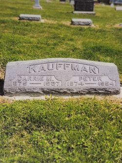
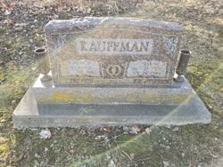
Peter Kauffman
| Birth | : | 10 Sep 1874 |
| Death | : | 25 Mar 1954 |
| Burial | : | Donington Old Cemetery, Donington, South Holland District, England |
| Coordinate | : | 52.9091670, -0.2055560 |
| Description | : | Lafayette Journal and Courier, Friday, March 26, 1954 Peter Kauffman Colburn - Peter Kauffman, 79, of Colburn, died at 9 p.m. Thursday in the Kennedy nursing home at Flora. He had been ill 10 weeks and in the nursing home three weeks. Born at Mulberry, he was married Aug. 16, 1896 to Carrie May Runkle, who died in 1937. He was a retired farmer. Surviving are four sons, Velda R., Walter J., and Charles C. Kauffman, all of Lafayette, and Robert D., of Colburn; five daughters, Mrs. Ruth M. Pearson, Radnor, Mrs. Mary Pearson, Bringhurst, Mrs. Evaleen I. Phillips, Mrs. Katherine... Read More |
frequently asked questions (FAQ):
-
Where is Peter Kauffman's memorial?
Peter Kauffman's memorial is located at: Donington Old Cemetery, Donington, South Holland District, England.
-
When did Peter Kauffman death?
Peter Kauffman death on 25 Mar 1954 in
-
Where are the coordinates of the Peter Kauffman's memorial?
Latitude: 52.9091670
Longitude: -0.2055560
Family Members:
Parent
Spouse
Siblings
Children
Flowers:
Nearby Cemetories:
1. Donington Old Cemetery
Donington, South Holland District, England
Coordinate: 52.9091670, -0.2055560
2. St. Mary and the Holy Rood Churchyard
Donington, South Holland District, England
Coordinate: 52.9072790, -0.2050080
3. Donington New Cemetery
Donington, South Holland District, England
Coordinate: 52.9071410, -0.2059100
4. St. Swithin's Churchyard
Bicker, Boston Borough, England
Coordinate: 52.9242080, -0.1798800
5. Bicker Cemetery
Bicker, Boston Borough, England
Coordinate: 52.9261110, -0.1794440
6. St. Margaret's Churchyard
Quadring, South Holland District, England
Coordinate: 52.8903400, -0.1819700
7. St. Mary's Churchyard
Swineshead, Boston Borough, England
Coordinate: 52.9446490, -0.1596530
8. St. Peter and St. Paul Churchyard
Gosberton, South Holland District, England
Coordinate: 52.8690870, -0.1629740
9. St. Peter and St. Paul's Churchyard
Wigtoft, Boston Borough, England
Coordinate: 52.9083330, -0.1236110
10. Gosberton Cemetery
Gosberton, South Holland District, England
Coordinate: 52.8659400, -0.1623000
11. Gosberton Baptist Church
Gosberton, South Holland District, England
Coordinate: 52.8651820, -0.1533940
12. St Gilbert and St Hugh Churchyard
Gosberton Clough, South Holland District, England
Coordinate: 52.8518081, -0.2166268
13. St. Mary The Virgin Churchyard
Sutterton, Boston Borough, England
Coordinate: 52.9016700, -0.0911111
14. Sutterton Village Cemetery
Sutterton, Boston Borough, England
Coordinate: 52.8994440, -0.0900000
15. South Lincolnshire Crematorium
Surfleet, South Holland District, England
Coordinate: 52.8451100, -0.1475110
16. St Andrews Churchyard
Helpringham, North Kesteven District, England
Coordinate: 52.9519900, -0.3065200
17. St Andrew's Churchyard
Helpringham, North Kesteven District, England
Coordinate: 52.9521000, -0.3065000
18. St. Peter and St. Paul Churchyard
Algarkirk, Boston Borough, England
Coordinate: 52.8995000, -0.0817800
19. Great Hale New Cemetery
Great Hale, North Kesteven District, England
Coordinate: 52.9678690, -0.2940500
20. St Andrew Churchyard
Horbling, South Kesteven District, England
Coordinate: 52.9028460, -0.3380407
21. St John the Baptist Churchyard
Great Hale, North Kesteven District, England
Coordinate: 52.9712140, -0.2914550
22. Surfleet Cemetery
Surfleet, South Holland District, England
Coordinate: 52.8391670, -0.1383330
23. St. Laurence Churchyard
Surfleet, South Holland District, England
Coordinate: 52.8369500, -0.1436110
24. St. Andrew's Churchyard
Billingborough, South Kesteven District, England
Coordinate: 52.8940140, -0.3397660

