
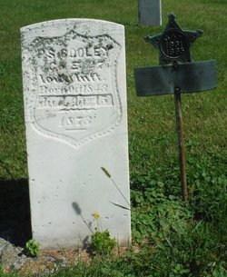
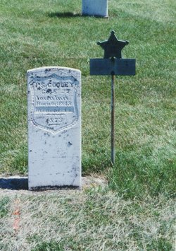

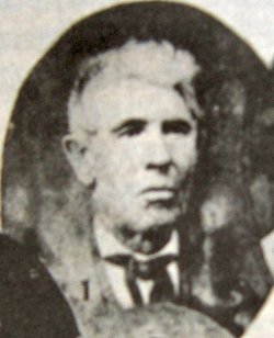
Peter S Cooley
| Birth | : | Dec 1843 Garnavillo, Clayton County, Iowa, USA |
| Death | : | 15 Aug 1873 Garnavillo, Clayton County, Iowa, USA |
| Burial | : | Garnavillo Cemetery, Garnavillo, Clayton County, USA |
| Coordinate | : | 42.8660300, -91.2390100 |
| Inscription | : | CIVIL WAR VETERAN |
| Description | : | In the Civil War he was a Private in "E" Co. 27th Iowa Infantry, enlistment date ?, then an 8th Corporal 20 Nov 1864, then 5th Corporal 1 Jul 1865. He was mustered out on 8 July 1865 at Clinton, IA. He died in 15 Aug 1873 as result of wounds received in the Third Battle Of Murfreesboro, also known as Wilkinson Pike or The Cedars, which was fought December 5–7, 1864, in Rutherford County, Tennessee, as part of the Franklin-Nashville Campaign. |
frequently asked questions (FAQ):
-
Where is Peter S Cooley's memorial?
Peter S Cooley's memorial is located at: Garnavillo Cemetery, Garnavillo, Clayton County, USA.
-
When did Peter S Cooley death?
Peter S Cooley death on 15 Aug 1873 in Garnavillo, Clayton County, Iowa, USA
-
Where are the coordinates of the Peter S Cooley's memorial?
Latitude: 42.8660300
Longitude: -91.2390100
Family Members:
Parent
Siblings

Flowers:


Nearby Cemetories:
1. Garnavillo Cemetery
Garnavillo, Clayton County, USA
Coordinate: 42.8660300, -91.2390100
2. Garnavillo Community Cemetery
Garnavillo, Clayton County, USA
Coordinate: 42.8656000, -91.2422100
3. Saint Joseph Cemetery
Garnavillo, Clayton County, USA
Coordinate: 42.8628006, -91.2502975
4. McClelland Cemetery
Garnavillo, Clayton County, USA
Coordinate: 42.8249879, -91.2084641
5. Pioneer Rock Cemetery
Ceres, Clayton County, USA
Coordinate: 42.8230591, -91.1863937
6. Clayton Center Cemetery
Clayton Center, Clayton County, USA
Coordinate: 42.8841705, -91.3225021
7. Zion Lutheran Cemetery
Clayton Center, Clayton County, USA
Coordinate: 42.8841705, -91.3249969
8. Clayton Cemetery
Clayton, Clayton County, USA
Coordinate: 42.9043999, -91.1641998
9. Tangeman Family Cemetery
Garnavillo, Clayton County, USA
Coordinate: 42.8580000, -91.1420000
10. Saint Michael Cemetery
Clayton County, USA
Coordinate: 42.8055992, -91.1802979
11. County Home Cemetery
Clayton Center, Clayton County, USA
Coordinate: 42.8916702, -91.3499985
12. Borcherding Cemetery
Jefferson Township, Clayton County, USA
Coordinate: 42.8182983, -91.1414032
13. Krumm Cemetery
Garber, Clayton County, USA
Coordinate: 42.7913760, -91.3023559
14. Colony Catholic Cemetery (Defunct)
Read Township, Clayton County, USA
Coordinate: 42.8830000, -91.3580000
15. National Cemetery
National, Clayton County, USA
Coordinate: 42.9536018, -91.2902985
16. Harford Cemetery
Wyalusing, Grant County, USA
Coordinate: 42.9401000, -91.1401800
17. Storck Cemetery
Guttenberg, Clayton County, USA
Coordinate: 42.7694335, -91.1834638
18. Saint Paula Cemetery
Osterdock, Clayton County, USA
Coordinate: 42.7635994, -91.1992035
19. Norwegian Church Cemetery
McGregor, Clayton County, USA
Coordinate: 42.9644400, -91.1764100
20. Meenan Cemetery
Communia, Clayton County, USA
Coordinate: 42.7999862, -91.3584693
21. Old Garber Cemetery
Garber, Clayton County, USA
Coordinate: 42.7560005, -91.2580032
22. Bagley Cemetery
Bagley, Grant County, USA
Coordinate: 42.9019012, -91.0907974
23. First Evangelical Lutheran Church Cemetery
McGregor, Clayton County, USA
Coordinate: 42.9718000, -91.1760000
24. Elkader Cemetery
Elkader, Clayton County, USA
Coordinate: 42.8541718, -91.4000015