
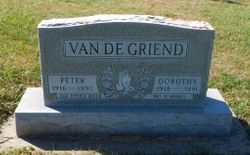
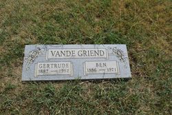
Peter Van De Griend
| Birth | : | 28 May 1916 Orange City, Sioux County, Iowa, USA |
| Death | : | 31 May 1992 Hawarden, Sioux County, Iowa, USA |
| Burial | : | Old St Nicholas Churchyard, Uphill, North Somerset Unitary Authority, England |
| Coordinate | : | 51.3203480, -2.9828110 |
| Description | : | Peter Van De Griend, 76, of Alcester, S.D., died Sunday, May 31, 1992, at Iowa Community Hospital in Hawarden. Services were Tuesday at the Christian Reformed church in Hawarden. The Rev. Marvin Vander Vliet officiated. Burial was in Pleasant Hill cemetery at Ireton, la., with military rites conducted by Bertram Post 276, American Legion of Ireton. Arrangements were under direction of Porter-Dow funeral home in Hawarden. Mr. Van De Griend was born May 28, 1916, in Orange City, the son of Ben and Gertrude (Zwagerman) Van De Griend. A four-year veteran of the army, he served in Germany during World War... Read More |
frequently asked questions (FAQ):
-
Where is Peter Van De Griend's memorial?
Peter Van De Griend's memorial is located at: Old St Nicholas Churchyard, Uphill, North Somerset Unitary Authority, England.
-
When did Peter Van De Griend death?
Peter Van De Griend death on 31 May 1992 in Hawarden, Sioux County, Iowa, USA
-
Where are the coordinates of the Peter Van De Griend's memorial?
Latitude: 51.3203480
Longitude: -2.9828110
Family Members:
Parent

Spouse

Siblings
Flowers:


Nearby Cemetories:
1. Old St Nicholas Churchyard
Uphill, North Somerset Unitary Authority, England
Coordinate: 51.3203480, -2.9828110
2. St Nicholas Churchyard (New)
Uphill, North Somerset Unitary Authority, England
Coordinate: 51.3246210, -2.9778420
3. Weston-super-Mare Emmanuel Churchyard
Weston-super-Mare, North Somerset Unitary Authority, England
Coordinate: 51.3458940, -2.9773860
4. Saint Peter and St. Paul Churchyard
Bleadon, North Somerset Unitary Authority, England
Coordinate: 51.3074000, -2.9458300
5. Saint Bridget Churchyard
Brean, Sedgemoor District, England
Coordinate: 51.2983000, -3.0100000
6. St. John the Baptist Churchyard
Weston-super-Mare, North Somerset Unitary Authority, England
Coordinate: 51.3523010, -2.9813260
7. St Mary the Virgin Churchyard
Hutton, North Somerset Unitary Authority, England
Coordinate: 51.3228030, -2.9306350
8. Weston-Super-Mare Cemetery
Weston-super-Mare, North Somerset Unitary Authority, England
Coordinate: 51.3541300, -2.9676900
9. St Christopher's Churchyard
Lympsham, Sedgemoor District, England
Coordinate: 51.2826740, -2.9546028
10. St. Augustine's Parish Churchyard
Locking, North Somerset Unitary Authority, England
Coordinate: 51.3322900, -2.9147683
11. Saint Pauls Churchyard
Kewstoke, North Somerset Unitary Authority, England
Coordinate: 51.3655500, -2.9568900
12. St Paul's Churchyard
Kewstoke, North Somerset Unitary Authority, England
Coordinate: 51.3655390, -2.9566120
13. St. Martin's Churchyard
Worle, North Somerset Unitary Authority, England
Coordinate: 51.3609960, -2.9301250
14. Saint Mary Magdalene Churchyard
Berrow, Sedgemoor District, England
Coordinate: 51.2669160, -3.0136980
15. The Blessed Virgin Mary
Axbridge, Sedgemoor District, England
Coordinate: 51.3112017, -2.8913443
16. St Andrew's Church
Loxton, North Somerset Unitary Authority, England
Coordinate: 51.2981560, -2.8962140
17. St Mark Churchyard
Weston-super-Mare, North Somerset Unitary Authority, England
Coordinate: 51.3640650, -2.9195540
18. Ebdon Road Crematorium and Cemetery
Weston-super-Mare, North Somerset Unitary Authority, England
Coordinate: 51.3707090, -2.9254530
19. St. Mary the Virgin Churchyard
East Brent, Sedgemoor District, England
Coordinate: 51.2624370, -2.9418620
20. St Michael and All Angels Parish Churchyard
Brent Knoll, Sedgemoor District, England
Coordinate: 51.2520000, -2.9539000
21. St. John the Baptist Churchyard
Biddisham, Sedgemoor District, England
Coordinate: 51.2764090, -2.8878950
22. Banwell War Memorial
Banwell, North Somerset Unitary Authority, England
Coordinate: 51.3278233, -2.8648124
23. St. Andrew's Churchyard
Banwell, North Somerset Unitary Authority, England
Coordinate: 51.3280700, -2.8637000
24. Saint Andrew Churchyard
Compton Bishop, Sedgemoor District, England
Coordinate: 51.2943290, -2.8678900