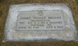
PFC James Wesley Bryant
| Birth | : | 25 Apr 1946 Omak, Okanogan County, Washington, USA |
| Death | : | 8 Sep 1966 Thừa Thiên-Huế, Vietnam |
| Burial | : | All Saints Churchyard, Rufforth, York Unitary Authority, England |
| Coordinate | : | 53.9568390, -1.1975690 |
| Description | : | PFC Bryant #2197280 MOS:0311 Rifleman. Upon arriving in Vietnam James was assigned to Golf Company, 2nd Battalion, 9th Marine Regiment, 3rd Marine Division. Golf Company was on a patrol, 3 kilometers east southeast of Nam Hoa when hostile forces engaged the Marines with sniper fire. James was wounded by sniper fire September 7 and was med evacuate to a United States Navy Hospital in Danang, where he died at 0955H, September 8, as a result of a gunshot wound to the head from hostile rifle fire. Tour of duty unknown. Survived by his parents, Charles E & Vivian J Bryant of 19 S Main, Omak, WA. |
frequently asked questions (FAQ):
-
Where is PFC James Wesley Bryant's memorial?
PFC James Wesley Bryant's memorial is located at: All Saints Churchyard, Rufforth, York Unitary Authority, England.
-
When did PFC James Wesley Bryant death?
PFC James Wesley Bryant death on 8 Sep 1966 in Thừa Thiên-Huế, Vietnam
-
Where are the coordinates of the PFC James Wesley Bryant's memorial?
Latitude: 53.9568390
Longitude: -1.1975690
Family Members:
Parent
Flowers:
Nearby Cemetories:
1. All Saints Churchyard
Rufforth, York Unitary Authority, England
Coordinate: 53.9568390, -1.1975690
2. St John's the Baptist Church
Hessay, York Unitary Authority, England
Coordinate: 53.9767283, -1.2027246
3. All Saints Churchyard
Long Marston, Harrogate Borough, England
Coordinate: 53.9506990, -1.2319230
4. St Mary Churchyard
Askham Richard, York Unitary Authority, England
Coordinate: 53.9254100, -1.1836800
5. All Saints Churchyard
Upper Poppleton, York Unitary Authority, England
Coordinate: 53.9776970, -1.1510780
6. St Nicholas Churchyard
Askham Bryan, York Unitary Authority, England
Coordinate: 53.9294600, -1.1581240
7. Marston Moor Battlefield Burial Pits
Long Marston, Harrogate Borough, England
Coordinate: 53.9713910, -1.2578580
8. St Stephen Churchyard
Acomb, York Unitary Authority, England
Coordinate: 53.9558840, -1.1289100
9. St John the Baptist Churchyard
Healaugh, Selby District, England
Coordinate: 53.9249590, -1.2424500
10. All Saints Churchyard
Moor Monkton, Harrogate Borough, England
Coordinate: 53.9976300, -1.2223700
11. St James Churchyard
Bilbrough, Selby District, England
Coordinate: 53.9119110, -1.1945130
12. St Everilda Churchyard
Nether Poppleton, York Unitary Authority, England
Coordinate: 53.9882060, -1.1403710
13. St Helen Churchyard
Bilton, Harrogate Borough, England
Coordinate: 53.9474910, -1.2761090
14. St Giles Churchyard
Copmanthorpe, York Unitary Authority, England
Coordinate: 53.9149240, -1.1410420
15. Dringhouses Cemetery
York, York Unitary Authority, England
Coordinate: 53.9297740, -1.1156780
16. Church of the Epiphany Churchyard
Tockwith, Harrogate Borough, England
Coordinate: 53.9653480, -1.2909130
17. St Barnabas Church
York, York Unitary Authority, England
Coordinate: 53.9639530, -1.1030490
18. St. Edward the Confessor
Dringhouses, York Unitary Authority, England
Coordinate: 53.9399810, -1.1061270
19. Moor Lane Burial Ground
Copmanthorpe, York Unitary Authority, England
Coordinate: 53.9096890, -1.1449400
20. Tyburn Cemetery
York, York Unitary Authority, England
Coordinate: 53.9486800, -1.1008400
21. St. Giles' Churchyard
Skelton, York Unitary Authority, England
Coordinate: 54.0019111, -1.1342660
22. Healaugh Priory
Healaugh, Selby District, England
Coordinate: 53.9110440, -1.2624190
23. St Mary Priory Churchyard
Nun Monkton, Harrogate Borough, England
Coordinate: 54.0149100, -1.2212150
24. St Paul Churchyard
Colton, Selby District, England
Coordinate: 53.8964660, -1.1773770


