
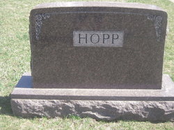
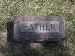
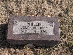
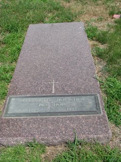
Phillip Hopp
| Birth | : | 18 Jul 1827 Germany |
| Death | : | 1893 Otoe County, Nebraska, USA |
| Burial | : | Sunny Hill Cemetery, Fenwick, Montcalm County, USA |
| Coordinate | : | 43.1319008, -85.0002975 |
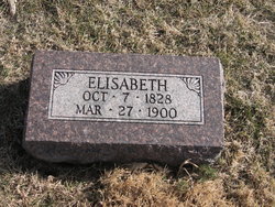
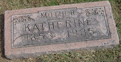
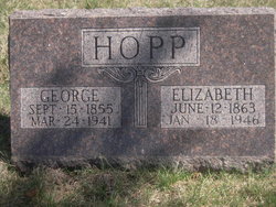
| Description | : | Phillip was the son of Johann & Anna Elizabeth (Rauscher) Hopp. He was born in Germany. He married Elizabeth Vogt and they had nine children: Catherine, George, Johanna Christina, Christina, Jacob, Mary, Elizabeth, Charles, and Louisa. |
frequently asked questions (FAQ):
-
Where is Phillip Hopp's memorial?
Phillip Hopp's memorial is located at: Sunny Hill Cemetery, Fenwick, Montcalm County, USA.
-
When did Phillip Hopp death?
Phillip Hopp death on 1893 in Otoe County, Nebraska, USA
-
Where are the coordinates of the Phillip Hopp's memorial?
Latitude: 43.1319008
Longitude: -85.0002975
Family Members:
Parent

Spouse
Siblings
Children

Flowers:


Nearby Cemetories:
1. Sunny Hill Cemetery
Fenwick, Montcalm County, USA
Coordinate: 43.1319008, -85.0002975
2. Palo Cemetery
Palo, Ionia County, USA
Coordinate: 43.1100000, -84.9380000
3. Vickeryville Cemetery
Vickeryville, Montcalm County, USA
Coordinate: 43.1917000, -84.9760971
4. Dalton Cemetery
Carson City, Montcalm County, USA
Coordinate: 43.1202400, -84.9157500
5. Snows Cemetery
Shiloh, Ionia County, USA
Coordinate: 43.0741997, -85.0357971
6. Vickeryville Old Order Mennonite Church Cemetery
Vickeryville, Montcalm County, USA
Coordinate: 43.1734880, -84.9342820
7. Woodard Lake Cemetery
Palo, Ionia County, USA
Coordinate: 43.0794990, -85.0591780
8. Clear Lake Cemetery
Fenwick, Montcalm County, USA
Coordinate: 43.1264000, -85.0943985
9. Bloomer Township Cemetery
Carson City, Montcalm County, USA
Coordinate: 43.1516991, -84.8949966
10. Sheridan Cemetery
Sheridan, Montcalm County, USA
Coordinate: 43.2061920, -85.0653030
11. Woodward Cemetery
Hubbardston, Ionia County, USA
Coordinate: 43.0893300, -84.8913600
12. Crippen Cemetery
Muir, Ionia County, USA
Coordinate: 43.0543500, -84.9362010
13. North Plains Cemetery
Ionia, Ionia County, USA
Coordinate: 43.0466995, -84.9552994
14. Old Ionia County Poor Farm Cemetery
Ionia, Ionia County, USA
Coordinate: 43.0404100, -85.0242200
15. Evergreen Township Cemetery
Sheridan, Montcalm County, USA
Coordinate: 43.2200600, -85.0472300
16. Hubbardston Old Catholic Cemetery
Hubbardston, Ionia County, USA
Coordinate: 43.0908960, -84.8590590
17. Greenop Memorial Cemetery
Orleans, Ionia County, USA
Coordinate: 43.0778008, -85.1346970
18. Orleans Township Cemetery
Orleans, Ionia County, USA
Coordinate: 43.0777670, -85.1357170
19. Higbee Cemetery
Orleans Township, Ionia County, USA
Coordinate: 43.0382996, -85.0868988
20. Westside Cemetery
Hubbardston, Ionia County, USA
Coordinate: 43.0928001, -84.8506012
21. Saint John the Baptist Catholic Cemetery
Hubbardston, Ionia County, USA
Coordinate: 43.0924988, -84.8486023
22. Crystal Cemetery
Crystal, Montcalm County, USA
Coordinate: 43.2347470, -84.9158600
23. Saint Marys Cemetery
Carson City, Montcalm County, USA
Coordinate: 43.1847600, -84.8508400
24. Carson City Cemetery
Carson City, Montcalm County, USA
Coordinate: 43.1850300, -84.8508400