Rachel Lorraine Gardner Rawley
| Birth | : | 8 May 1914 Randle, Lewis County, Washington, USA |
| Death | : | 27 Feb 1996 Tacoma, Pierce County, Washington, USA |
| Burial | : | Oak Ridge Cemetery, Coshocton, Coshocton County, USA |
| Coordinate | : | 40.2780991, -81.8610992 |
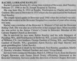
| Description | : | Rachel Lorraine Rawley, 81, a long time resident of Brewster, died Tuesday, February 27, 1996 in the St. Joseph Hospital in Tacoma. She was born May 8, 1914 at Randle, Washington to Charles and Lenora Gardner. She came to Brewster in 1935 where she met and married her husband Fred Rawley. The couple raised apples in Brewster until 1968 when the orchard was sold. Rachel also worked at the Brewster Hospital for a number of years after raising two sons. Rachel was a member of the Brewster Jr. Women's Club and the Brewster Riding Club. She was also an avid bowler in her... Read More |
frequently asked questions (FAQ):
-
Where is Rachel Lorraine Gardner Rawley's memorial?
Rachel Lorraine Gardner Rawley's memorial is located at: Oak Ridge Cemetery, Coshocton, Coshocton County, USA.
-
When did Rachel Lorraine Gardner Rawley death?
Rachel Lorraine Gardner Rawley death on 27 Feb 1996 in Tacoma, Pierce County, Washington, USA
-
Where are the coordinates of the Rachel Lorraine Gardner Rawley's memorial?
Latitude: 40.2780991
Longitude: -81.8610992
Family Members:
Flowers:
Nearby Cemetories:
1. Oak Ridge Cemetery
Coshocton, Coshocton County, USA
Coordinate: 40.2780991, -81.8610992
2. Caldersburg Cemetery
Roscoe, Coshocton County, USA
Coordinate: 40.2755390, -81.8798700
3. Unidentified Cemetery #1
Coshocton, Coshocton County, USA
Coordinate: 40.2753080, -81.8803050
4. Roscoe Cemetery
Coshocton, Coshocton County, USA
Coordinate: 40.2821000, -81.8841000
5. South Lawn Cemetery
Coshocton, Coshocton County, USA
Coordinate: 40.2560997, -81.8597031
6. Canal Lewisville Cemetery
Canal Lewisville, Coshocton County, USA
Coordinate: 40.3012500, -81.8357100
7. Coshocton County Infirmary Cemetery
Coshocton, Coshocton County, USA
Coordinate: 40.2694450, -81.8166500
8. Reamer Cemetery
Coshocton County, USA
Coordinate: 40.3194008, -81.8317032
9. Prairie Chapel Church Cemetery
Coshocton, Coshocton County, USA
Coordinate: 40.3049000, -81.9124000
10. Coshocton County Memory Gardens
Coshocton, Coshocton County, USA
Coordinate: 40.3234825, -81.8310089
11. Oak Grove Cemetery
Coshocton County, USA
Coordinate: 40.3032990, -81.8005981
12. Warner Methodist Cemetery
Conesville, Coshocton County, USA
Coordinate: 40.2389520, -81.9109620
13. Machpelahs Burial Acres
Keene, Coshocton County, USA
Coordinate: 40.3208950, -81.9126210
14. Mount Zion Cemetery
Coshocton, Coshocton County, USA
Coordinate: 40.2344017, -81.8035965
15. Bible Cemetery
Keene, Coshocton County, USA
Coordinate: 40.3330380, -81.8990940
16. Tyndall Cemetery
Coshocton County, USA
Coordinate: 40.2167015, -81.8843994
17. Davis Cemetery
Conesville, Coshocton County, USA
Coordinate: 40.2154312, -81.8808899
18. Keene Methodist Cemetery
Keene, Coshocton County, USA
Coordinate: 40.3431800, -81.8662500
19. Hill Cemetery
Coshocton County, USA
Coordinate: 40.3208008, -81.7878036
20. Keene Old Presbyterian Church Cemetery
Coshocton County, USA
Coordinate: 40.3480700, -81.8707900
21. Christian Chapel Cemetery
Coshocton County, USA
Coordinate: 40.2271470, -81.9263480
22. Pleasant Hill Baptist Cemetery
Coshocton, Coshocton County, USA
Coordinate: 40.2547380, -81.9496810
23. Saint Pauls Cemetery
Coshocton County, USA
Coordinate: 40.2103004, -81.8208008
24. Baptist Cemetery
West Lafayette, Coshocton County, USA
Coordinate: 40.2756310, -81.7585220


