
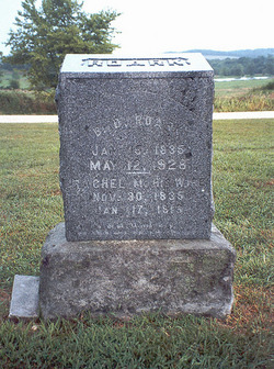

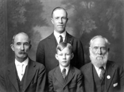
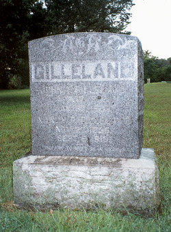
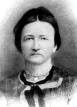
Rachel Margaret Gilleland Roark
| Birth | : | 30 Nov 1835 Mount Pleasant, Miller County, Missouri, USA |
| Death | : | 17 Jan 1916 Olean, Miller County, Missouri, USA |
| Burial | : | Acacia Memorial Park, Modesto, Stanislaus County, USA |
| Coordinate | : | 37.6481080, -120.9836610 |
| Description | : | Daughter of Samuel S. and Mary B. (Welborn) Gilleland, second wife of Benjamin Downing Roark, married November 24, 1853, Miller County, Missouri. Unknown Newspaper, January 1916 Rachel Margaret Gilleland was born Nov. 30, 1835 and was married to B.D. Roark in the year 1853. Aunt Rachel, as she was called by all who knew and loved her, was the mother of eleven children, seven sons and four daughters. These children have all grown to man- and womanhood except the second child, a little girl, who was called to that home above, there to await the coming of the dear... Read More |
frequently asked questions (FAQ):
-
Where is Rachel Margaret Gilleland Roark's memorial?
Rachel Margaret Gilleland Roark's memorial is located at: Acacia Memorial Park, Modesto, Stanislaus County, USA.
-
When did Rachel Margaret Gilleland Roark death?
Rachel Margaret Gilleland Roark death on 17 Jan 1916 in Olean, Miller County, Missouri, USA
-
Where are the coordinates of the Rachel Margaret Gilleland Roark's memorial?
Latitude: 37.6481080
Longitude: -120.9836610
Family Members:
Parent
Spouse
Siblings
Children


Nearby Cemetories:
1. Acacia Memorial Park
Modesto, Stanislaus County, USA
Coordinate: 37.6481080, -120.9836610
2. Modesto Pioneer Cemetery
Modesto, Stanislaus County, USA
Coordinate: 37.6473350, -120.9829040
3. Modesto Citizens Cemetery
Modesto, Stanislaus County, USA
Coordinate: 37.6472930, -120.9845570
4. Modesto County Cemetery
Modesto, Stanislaus County, USA
Coordinate: 37.6492400, -120.9813800
5. Saint Stanislaus Catholic Cemetery
Modesto, Stanislaus County, USA
Coordinate: 37.6473610, -120.9808440
6. Ceres Memorial Park
Ceres, Stanislaus County, USA
Coordinate: 37.5958214, -120.9634399
7. Lakewood Memorial Park
Hughson, Stanislaus County, USA
Coordinate: 37.6199760, -120.8975983
8. Good Shepherd Catholic Cemetery
Modesto, Stanislaus County, USA
Coordinate: 37.6853130, -121.0672890
9. Wood Colony Cemetery
Salida, Stanislaus County, USA
Coordinate: 37.6893730, -121.0682144
10. Burwood Cemetery
Escalon, San Joaquin County, USA
Coordinate: 37.7616997, -120.9593964
11. Langworth Cemetery
Oakdale, Stanislaus County, USA
Coordinate: 37.7580986, -120.8957977
12. Ripon Cemetery
Ripon, San Joaquin County, USA
Coordinate: 37.7420311, -121.1238708
13. Oakdale Citizens Cemetery
Oakdale, Stanislaus County, USA
Coordinate: 37.7624600, -120.8388800
14. Oaklawn Memorial Park
Oakdale, Stanislaus County, USA
Coordinate: 37.7711945, -120.8486862
15. Saint John's Catholic Cemetery
Escalon, San Joaquin County, USA
Coordinate: 37.7994537, -121.0705185
16. Denair Cemetery
Denair, Stanislaus County, USA
Coordinate: 37.5293999, -120.8199997
17. Grayson Cemetery
Grayson, Stanislaus County, USA
Coordinate: 37.5594559, -121.1802826
18. Martin Cemetery
Waterford, Stanislaus County, USA
Coordinate: 37.6684360, -120.7582160
19. Turlock Memorial Park
Turlock, Stanislaus County, USA
Coordinate: 37.4937592, -120.8659821
20. Valley Home Memorial Park
Oakdale, Stanislaus County, USA
Coordinate: 37.8275528, -120.9333267
21. Saint Francis Episcopal Church Columbarium
Turlock, Stanislaus County, USA
Coordinate: 37.5014300, -120.8368400
22. Patterson District Cemetery
Patterson, Stanislaus County, USA
Coordinate: 37.5268135, -121.1728287
23. Atlanta Cemetery
Five Corners, San Joaquin County, USA
Coordinate: 37.8270035, -121.1420135
24. North Hilmar Cemetery
Hilmar, Merced County, USA
Coordinate: 37.4146614, -120.8864288