
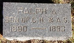

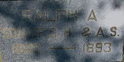
Ralph E. Pilcher
| Birth | : | 4 Oct 1889 Cloud County, Kansas, USA |
| Death | : | 29 May 1893 Cloud County, Kansas, USA |
| Burial | : | Tumalo Cemetery, Tumalo, Deschutes County, USA |
| Coordinate | : | 44.1652985, -121.3181000 |
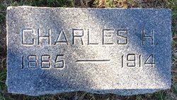
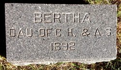
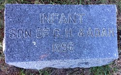
| Description | : | Glasco Sun, June 30, 1893, page 1: Ralf E. Pilcher was born in Cloud County, Kansas, October 4th, 1889. Died May 29th, 1893, being 3 years, 7 months, 23 days old. He was a bright boy, a joy to the household, and a pet to his grandpa. He was the second to pass away, his little sister dying ten months before him. His mother died four days later. Cloud County Cemetery Book, Volume 4, page 152: (middle initial A.) son of C.H. & A.S. Pilcher |
frequently asked questions (FAQ):
-
Where is Ralph E. Pilcher's memorial?
Ralph E. Pilcher's memorial is located at: Tumalo Cemetery, Tumalo, Deschutes County, USA.
-
When did Ralph E. Pilcher death?
Ralph E. Pilcher death on 29 May 1893 in Cloud County, Kansas, USA
-
Where are the coordinates of the Ralph E. Pilcher's memorial?
Latitude: 44.1652985
Longitude: -121.3181000
Family Members:
Parent
Siblings
Flowers:


Nearby Cemetories:
1. Tumalo Cemetery
Tumalo, Deschutes County, USA
Coordinate: 44.1652985, -121.3181000
2. Deschutes Memorial Gardens
Bend, Deschutes County, USA
Coordinate: 44.1183014, -121.2906036
3. Cooley-Tetherow Meek Cutoff Lone Burial Site
Redmond, Deschutes County, USA
Coordinate: 44.2246700, -121.2066700
4. Trinity Episcopal Church Columbarium
Bend, Deschutes County, USA
Coordinate: 44.0558840, -121.3178980
5. Greenwood Cemetery
Bend, Deschutes County, USA
Coordinate: 44.0569000, -121.2866974
6. Pilot Butte Cemetery
Bend, Deschutes County, USA
Coordinate: 44.0525360, -121.2886150
7. Redmond Memorial Cemetery
Redmond, Deschutes County, USA
Coordinate: 44.2449989, -121.2016983
8. Cyrus Cemetery
Cloverdale, Deschutes County, USA
Coordinate: 44.2693500, -121.4727000
9. Camp Polk Cemetery
Cloverdale, Deschutes County, USA
Coordinate: 44.3231010, -121.5139008
10. Pilgrims Rest Cemetery
Powell Butte, Crook County, USA
Coordinate: 44.2038400, -121.0271400
11. Saint Winefrides Garden
Sisters, Deschutes County, USA
Coordinate: 44.2922940, -121.5674410
12. Terrebonne Pioneer Cemetery
Terrebonne, Deschutes County, USA
Coordinate: 44.3486100, -121.1502800
13. Lost Immigrant Grave
Alfalfa, Deschutes County, USA
Coordinate: 44.0601578, -121.0321198
14. McCoin Orchard Grave Site
Opal City, Jefferson County, USA
Coordinate: 44.4284000, -121.0888100
15. Harper Cemetery
La Pine, Deschutes County, USA
Coordinate: 43.8582993, -121.4458008
16. Grandview Cemetery
Jefferson County, USA
Coordinate: 44.4944000, -121.3707962
17. Gray Butte Cemetery
Culver, Jefferson County, USA
Coordinate: 44.4626007, -121.0992966
18. Vandevert Gravesite
Sunriver, Deschutes County, USA
Coordinate: 43.8315163, -121.4457169
19. Juniper Haven Cemetery
Prineville, Crook County, USA
Coordinate: 44.3153000, -120.8471985
20. Dehler Grizzly Mountain Cemetery
Prineville, Crook County, USA
Coordinate: 44.4251800, -120.9356100
21. Lost Meek Rimrock Springs Burial Site
Grizzly, Jefferson County, USA
Coordinate: 44.4954450, -121.0546000
22. Culver IOOF Cemetery
Culver, Jefferson County, USA
Coordinate: 44.5344009, -121.1691971
23. Craig Grave
Lane County, USA
Coordinate: 44.2461014, -121.8427963
24. Methodist Hill Cemetery
Metolius, Jefferson County, USA
Coordinate: 44.5639000, -121.2091980