
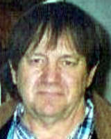

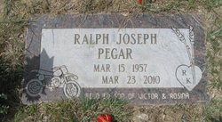
Ralph Joseph Pegar
| Birth | : | 15 Mar 1957 Havre, Hill County, Montana, USA |
| Death | : | 23 Mar 2010 |
| Burial | : | Highland Cemetery, Highland, Doniphan County, USA |
| Coordinate | : | 39.8555984, -95.2514038 |
| Description | : | BIG SANDY - Lifelong Montana resident Ralph Joseph Pegar, 53, who farmed southeast of Big Sandy and enjoyed attending local auctions, socializing with friends and neighbors and riding his motorcycle, died of internal injuries Tuesday in Big Sandy after his motorcycle struck a large rock and he was thrown from the vehicle. A vigil is 7 this evening at St. Margaret Mary's Catholic Church in Big Sandy. Funeral Mass is 11 a.m. Saturday at St. Margaret Mary's Catholic Church, with burial in Big Sandy Cemetery. A lunch will be held at the church after the burial. Rockman Funeral Chapel... Read More |
frequently asked questions (FAQ):
-
Where is Ralph Joseph Pegar's memorial?
Ralph Joseph Pegar's memorial is located at: Highland Cemetery, Highland, Doniphan County, USA.
-
When did Ralph Joseph Pegar death?
Ralph Joseph Pegar death on 23 Mar 2010 in
-
Where are the coordinates of the Ralph Joseph Pegar's memorial?
Latitude: 39.8555984
Longitude: -95.2514038
Family Members:
Parent

Flowers:


Nearby Cemetories:
1. Highland Cemetery
Highland, Doniphan County, USA
Coordinate: 39.8555984, -95.2514038
2. Walnut Grove Cemetery
Highland, Doniphan County, USA
Coordinate: 39.9000702, -95.2438736
3. Iola Cemetery
Sparks, Doniphan County, USA
Coordinate: 39.8417015, -95.1896973
4. Wolf River Cemetery
Troy, Doniphan County, USA
Coordinate: 39.8125000, -95.2200012
5. Hedrick Cemetery
Iowa Point, Doniphan County, USA
Coordinate: 39.8672800, -95.1818500
6. Iowa Point Cemetery
Iowa Point, Doniphan County, USA
Coordinate: 39.9157982, -95.2275009
7. Dittemore Cemetery
Doniphan County, USA
Coordinate: 39.7911000, -95.2364500
8. Pleasant Hill Cemetery
Leona, Doniphan County, USA
Coordinate: 39.8162193, -95.3224869
9. Collins Family Cemetery
White Cloud, Doniphan County, USA
Coordinate: 39.9221992, -95.2969284
10. Oak Hill Cemetery
Severance, Doniphan County, USA
Coordinate: 39.7780991, -95.2557983
11. Saint James Cemetery
Fanning, Doniphan County, USA
Coordinate: 39.8349310, -95.1533590
12. Fanning Cemetery
Fanning, Doniphan County, USA
Coordinate: 39.8347015, -95.1528015
13. Burrell Cemetery
Doniphan County, USA
Coordinate: 39.7838400, -95.1952300
14. Steanson Family Cemetery
Moray, Doniphan County, USA
Coordinate: 39.7840004, -95.1903381
15. Lafayette Cemetery
Sparks, Doniphan County, USA
Coordinate: 39.8707000, -95.1410600
16. Springer Cemetery
Doniphan County, USA
Coordinate: 39.7695389, -95.2683792
17. Wood Cemetery
Doniphan, Doniphan County, USA
Coordinate: 39.7956600, -95.1640800
18. Pleasant Ridge Cemetery
Brown County, USA
Coordinate: 39.7928009, -95.3654022
19. Moray Cemetery
Moray, Doniphan County, USA
Coordinate: 39.7655106, -95.1713181
20. Bitner Cemetery
Severance, Doniphan County, USA
Coordinate: 39.7439003, -95.2466965
21. Mosquito Creek Cemetery
Doniphan County, USA
Coordinate: 39.8376400, -95.0988100
22. Victory Cemetery
Denton, Doniphan County, USA
Coordinate: 39.7327995, -95.2358017
23. Kenyon Cemetery
Robinson, Brown County, USA
Coordinate: 39.9122000, -95.3964600
24. Ununda Cemetery
Robinson, Brown County, USA
Coordinate: 39.8582993, -95.4143982