

Ralph Kann
| Birth | : | 29 May 1899 Jefferson County, Iowa, USA |
| Death | : | 16 Sep 1989 Fairfield, Jefferson County, Iowa, USA |
| Burial | : | Evergreen Cemetery, Fairfield, Jefferson County, USA |
| Coordinate | : | 41.0138600, -91.9562100 |
| Plot | : | 5th.016 |
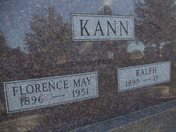
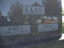
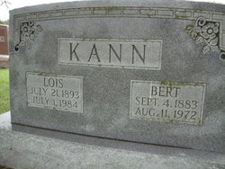
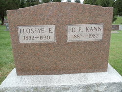
| Description | : | Ralph was married to Forence May McWhirter, then to Marie E Maasdam, then to Kathleen E. Nelson. The headstone for Florence also has the name of Ralph Kann and "1899" on it (his was a pre-need inscription, evidently); however, he is buried with his second wife Marie and they share a common headstone with both their names and dates engraved. Florence is on 4th.030, which is directly adjacent to Ralph and Marie on 5th.016. --------- Fairfield Ledger Monday, September 18, 1989 Ralph KANN rite Wednesday Ralph KANN, 90, route 4, died at 4:37 p.m. Saturday, Sept. 16, 1989, at Nelson Nursing Home. The service... Read More |
frequently asked questions (FAQ):
-
Where is Ralph Kann's memorial?
Ralph Kann's memorial is located at: Evergreen Cemetery, Fairfield, Jefferson County, USA.
-
When did Ralph Kann death?
Ralph Kann death on 16 Sep 1989 in Fairfield, Jefferson County, Iowa, USA
-
Where are the coordinates of the Ralph Kann's memorial?
Latitude: 41.0138600
Longitude: -91.9562100
Family Members:
Parent

Spouse

Siblings
Flowers:


Nearby Cemetories:
1. Evergreen Cemetery
Fairfield, Jefferson County, USA
Coordinate: 41.0138600, -91.9562100
2. Old Fairfield Cemetery
Fairfield, Jefferson County, USA
Coordinate: 41.0148000, -91.9598000
3. Memorial Lawn Cemetery
Fairfield, Jefferson County, USA
Coordinate: 41.0068000, -91.9805000
4. Switzer Cemetery
Fairfield, Jefferson County, USA
Coordinate: 41.0368996, -91.9096985
5. Bradshaw Cemetery
Jefferson County, USA
Coordinate: 40.9766998, -91.9032974
6. Roth Cemetery
Fairfield, Jefferson County, USA
Coordinate: 40.9589005, -91.9574966
7. Bethesda Cemetery
Fairfield, Jefferson County, USA
Coordinate: 41.0019000, -91.8796000
8. Smith Family Cemetery
Libertyville, Jefferson County, USA
Coordinate: 40.9972416, -92.0362857
9. Wheeler Cemetery
Jefferson County, USA
Coordinate: 41.0797000, -91.9185500
10. Galliher Cemetery
Glasgow, Jefferson County, USA
Coordinate: 40.9666892, -91.8835038
11. Upper Richwoods Cemetery
Salina, Jefferson County, USA
Coordinate: 41.0602989, -91.8807983
12. Jefferson County Poor Farm Cemetery
Libertyville, Jefferson County, USA
Coordinate: 40.9416900, -91.9996200
13. Perlee Cemetery
Perlee, Jefferson County, USA
Coordinate: 41.0805750, -91.8993380
14. Pattison Cemetery
Fairfield, Jefferson County, USA
Coordinate: 40.9444008, -91.9049988
15. Moorman Cemetery
Fairfield, Jefferson County, USA
Coordinate: 41.0452995, -92.0622025
16. Wright Cemetery
Fairfield, Jefferson County, USA
Coordinate: 40.9524000, -91.8728000
17. Antioch Cemetery
Fairfield, Jefferson County, USA
Coordinate: 41.1002998, -91.9147034
18. Moyer Cemetery
Fairfield, Jefferson County, USA
Coordinate: 41.1046982, -91.9330978
19. Cumberland Cemetery
Jefferson County, USA
Coordinate: 40.9248000, -91.9903000
20. Gregg Cemetery
Jefferson County, USA
Coordinate: 41.0078011, -92.0811005
21. Salina Cemetery
Salina, Jefferson County, USA
Coordinate: 41.0419006, -91.8330994
22. McCleary Cemetery
Jefferson County, USA
Coordinate: 40.9892006, -92.0805969
23. Brooks Cemetery
Jefferson County, USA
Coordinate: 41.0635986, -92.0693970
24. Thompson Cemetery
Jefferson County, USA
Coordinate: 40.9155998, -91.9772034