
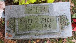
Ralph Vernon Spiker
| Birth | : | 15 Apr 1917 Oakland, Garrett County, Maryland, USA |
| Death | : | 24 Aug 1966 Oakland, Garrett County, Maryland, USA |
| Burial | : | St Thomas Churchyard Friarmere, Delph, Metropolitan Borough of Oldham, England |
| Coordinate | : | 53.5778800, -2.0285500 |
| Description | : | OBITUARY: The Cumberland News (Cumberland, Maryland), Thursday, 25 August 1966 - Page 16 OAKLAND -- Ralph Vernon Spiker, 48, of Sang Run, was pronounced dead on arrival yesterday at Garrett County Memorial Hospital. A native of Garrett County, he was a son of Mrs. Martha E. (Lewis) Spiker and the late Walter S. Spiker. He was employed as a carpenter and was a member of the Pine Grove Church of the Brethren. Also surviving are his widow, Ruth (Friend) Spiker; three sons, Adrian Spiker, McHenry, and Joseph and WIlliam Spiker, both at home; |
frequently asked questions (FAQ):
-
Where is Ralph Vernon Spiker's memorial?
Ralph Vernon Spiker's memorial is located at: St Thomas Churchyard Friarmere, Delph, Metropolitan Borough of Oldham, England.
-
When did Ralph Vernon Spiker death?
Ralph Vernon Spiker death on 24 Aug 1966 in Oakland, Garrett County, Maryland, USA
-
Where are the coordinates of the Ralph Vernon Spiker's memorial?
Latitude: 53.5778800
Longitude: -2.0285500
Family Members:
Parent

Spouse

Siblings
Children

Flowers:


Nearby Cemetories:
1. St Thomas Churchyard Friarmere
Delph, Metropolitan Borough of Oldham, England
Coordinate: 53.5778800, -2.0285500
2. Delph Independent Chapelyard
Delph, Metropolitan Borough of Oldham, England
Coordinate: 53.5690839, -2.0225845
3. Christ Church Churchyard
Denshaw, Metropolitan Borough of Oldham, England
Coordinate: 53.5918070, -2.0385720
4. St. Chad Churchyard
Uppermill, Metropolitan Borough of Oldham, England
Coordinate: 53.5542570, -1.9901190
5. Holy Trinity Churchyard
Waterhead, Metropolitan Borough of Oldham, England
Coordinate: 53.5507100, -2.0738400
6. Holy Trinity Churchyard
Shaw, Metropolitan Borough of Oldham, England
Coordinate: 53.5749940, -2.0991780
7. St. John The Baptist Churchyard
Oldham, Metropolitan Borough of Oldham, England
Coordinate: 53.5424690, -2.0680150
8. Crompton Cemetery
Shaw, Metropolitan Borough of Oldham, England
Coordinate: 53.5799840, -2.1003410
9. St. John the Baptist Churchyard
Heybridge, Central Coast Council, Australia
Coordinate: 53.5415973, -2.0699727
10. Greenacres Congregational Church
Oldham, Metropolitan Borough of Oldham, England
Coordinate: 53.5455200, -2.0788100
11. Greenacres Cemetery
Oldham, Metropolitan Borough of Oldham, England
Coordinate: 53.5455490, -2.0820510
12. St. Thomas Churchyard
Newhey, Metropolitan Borough of Rochdale, England
Coordinate: 53.6019166, -2.0958889
13. Friends Burial Ground at Turf Lane
Royton, Metropolitan Borough of Oldham, England
Coordinate: 53.5620200, -2.1039660
14. St Thomas'
Oldham, Metropolitan Borough of Oldham, England
Coordinate: 53.5366318, -2.0724053
15. Lees Cemetery
Oldham, Metropolitan Borough of Oldham, England
Coordinate: 53.5347540, -2.0739260
16. Saint Paul Churchyard
Royton, Metropolitan Borough of Oldham, England
Coordinate: 53.5653330, -2.1261450
17. St. Mary Church of England Churchyard
Oldham, Metropolitan Borough of Oldham, England
Coordinate: 53.5428030, -2.1104030
18. Royton Cemetery
Royton, Metropolitan Borough of Oldham, England
Coordinate: 53.5727450, -2.1302850
19. St. George Parish Churchyard
Mossley, Metropolitan Borough of Tameside, England
Coordinate: 53.5164000, -2.0486200
20. St Bartholomew Churchyard
Marsden, Metropolitan Borough of Kirklees, England
Coordinate: 53.6010890, -1.9294800
21. Second Anglican Chapel in Marsden
Marsden, Metropolitan Borough of Kirklees, England
Coordinate: 53.6010690, -1.9290030
22. Buckley Hill Chapel
Marsden, Metropolitan Borough of Kirklees, England
Coordinate: 53.6019430, -1.9274970
23. Mossley Cemetery
Mossley, Metropolitan Borough of Tameside, England
Coordinate: 53.5092100, -2.0332700
24. St Matthew Churchyard
Chadderton, Metropolitan Borough of Oldham, England
Coordinate: 53.5565975, -2.1528452