
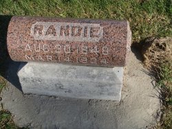
Randie Olson Knutson
| Birth | : | 30 Aug 1848 Norway |
| Death | : | 14 Mar 1924 Hardin County, Iowa, USA |
| Burial | : | Gays Mills Cemetery, Gays Mills, Crawford County, USA |
| Coordinate | : | 43.3244019, -90.8392029 |
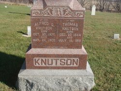
| Description | : | From the 1911 book Past and Present of Hardin County Iowa, pp. 564-566: Thomas Knutson received a limited education in the public schools of Norway. He lived with his father until 1871. In 1873 he was married to Randie Olson, of northern Norway, daughter of Jerman and Julia (Neylagan) Olson, of Norway. They came to America in 1864 and located in Ellis township, Hardin county, Iowa. They later bought a farm in Story county, this state, and lived there eighteen years, then sold out and returned to Norway and there the father's death occurred in 1894; his wife preceded him to... Read More |
frequently asked questions (FAQ):
-
Where is Randie Olson Knutson's memorial?
Randie Olson Knutson's memorial is located at: Gays Mills Cemetery, Gays Mills, Crawford County, USA.
-
When did Randie Olson Knutson death?
Randie Olson Knutson death on 14 Mar 1924 in Hardin County, Iowa, USA
-
Where are the coordinates of the Randie Olson Knutson's memorial?
Latitude: 43.3244019
Longitude: -90.8392029
Family Members:
Spouse
Children

Flowers:


Nearby Cemetories:
1. Brown Family Cemetery
Gays Mills, Crawford County, USA
Coordinate: 43.3117600, -90.8431100
2. Bell Center Cemetery
Bell Center, Crawford County, USA
Coordinate: 43.2851000, -90.8271330
3. Crow Creek Cemetery
Prairie du Chien, Crawford County, USA
Coordinate: 43.2744200, -90.8162400
4. McAuley-Halls-Branch Pioneer Cemetery
Mount Sterling, Crawford County, USA
Coordinate: 43.3173800, -90.9168430
5. Coleman-Whiteaker Cemetery
Bell Center, Crawford County, USA
Coordinate: 43.2919998, -90.7740021
6. Yankeetown Cemetery
Soldiers Grove, Crawford County, USA
Coordinate: 43.3751340, -90.8010520
7. Mount Sterling Lutheran Cemetery
Mount Sterling, Crawford County, USA
Coordinate: 43.3174000, -90.9259830
8. Mook Cemetery
Rolling Ground, Crawford County, USA
Coordinate: 43.3278000, -90.7400000
9. Montgomeryville Cemetery
Montgomeryville, Crawford County, USA
Coordinate: 43.3567830, -90.7451000
10. Utica Lutheran Church Cemetery
Mount Sterling, Crawford County, USA
Coordinate: 43.3506000, -90.9381830
11. Evergreen Cemetery
Seneca, Crawford County, USA
Coordinate: 43.2966995, -90.9411011
12. Forest Hill Cemetery
Soldiers Grove, Crawford County, USA
Coordinate: 43.3923830, -90.7821000
13. Haney Valley Cemetery
Petersburg, Crawford County, USA
Coordinate: 43.2461014, -90.8681030
14. Mount Pleasant Cemetery
Mount Zion, Crawford County, USA
Coordinate: 43.2523500, -90.7845170
15. Towerville Cemetery
Towerville, Crawford County, USA
Coordinate: 43.4035350, -90.8878540
16. Tell Cemetery
Towerville, Crawford County, USA
Coordinate: 43.4113700, -90.8374800
17. Saint Phillips Catholic Cemetery
Rolling Ground, Crawford County, USA
Coordinate: 43.3280400, -90.7195700
18. South Kickapoo Cemetery
Soldiers Grove, Crawford County, USA
Coordinate: 43.4166170, -90.8375170
19. Haney Ridge Cemetery
Barnum, Crawford County, USA
Coordinate: 43.2343830, -90.7907330
20. Eitsert Cemetery
Fairview, Crawford County, USA
Coordinate: 43.3602982, -90.9638977
21. Barnum Cemetery
Barnum, Crawford County, USA
Coordinate: 43.2226670, -90.8343670
22. North Kickapoo Cemetery
Folsom, Vernon County, USA
Coordinate: 43.4276170, -90.8377330
23. Union Hill Cemetery
Mount Zion, Crawford County, USA
Coordinate: 43.2557210, -90.7309770
24. Townsend Family Farm Cemetery
Readstown, Vernon County, USA
Coordinate: 43.4281820, -90.8009280