
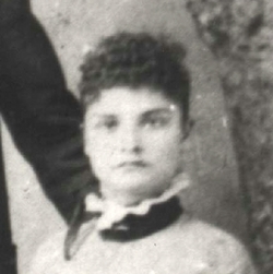
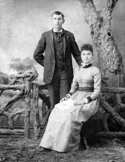
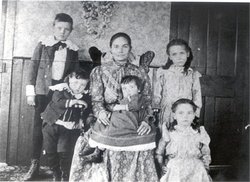
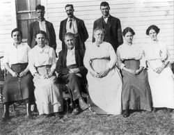
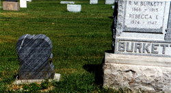
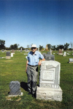
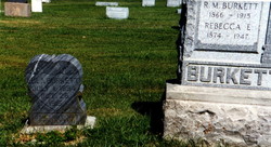
Rebecca Elizabeth Brock Burkett
| Birth | : | 28 Jan 1874 Corydon, Harrison County, Indiana, USA |
| Death | : | 27 Aug 1947 West Monroe, Ouachita Parish, Louisiana, USA |
| Burial | : | Aldouane Roman Catholic Cemetery, Aldouane, Kent County, Canada |
| Coordinate | : | 46.7098670, -64.8985700 |
| Plot | : | Block 2, Row 11, Lot 34, graves 3 & 4 |
| Description | : | BY HER GRANDSON She was the one who caught me as I was making entry into this world as my mother jumped out of bed during my birth. She was the one who probably saved my life when my parents, on doctor's advice, returned with me from Blackwell, Oklahoma for the purpose of burying me in the family cemetery as no diagnosis could be made as to what was wrong with me. But one look at me by Grandma brought out immediately the startling fact that my Mother was Breast feeding me mostly water and that I was starving to death.... Read More |
frequently asked questions (FAQ):
-
Where is Rebecca Elizabeth Brock Burkett's memorial?
Rebecca Elizabeth Brock Burkett's memorial is located at: Aldouane Roman Catholic Cemetery, Aldouane, Kent County, Canada.
-
When did Rebecca Elizabeth Brock Burkett death?
Rebecca Elizabeth Brock Burkett death on 27 Aug 1947 in West Monroe, Ouachita Parish, Louisiana, USA
-
Where are the coordinates of the Rebecca Elizabeth Brock Burkett's memorial?
Latitude: 46.7098670
Longitude: -64.8985700
Family Members:
Parent
Spouse
Siblings

Children
Flowers:


Nearby Cemetories:
1. Aldouane Roman Catholic Cemetery
Aldouane, Kent County, Canada
Coordinate: 46.7098670, -64.8985700
2. Saint Louis de Gonzague
Richibucto, Kent County, Canada
Coordinate: 46.6882680, -64.8624160
3. Richibucto Protestant Cemetery
Richibucto, Kent County, Canada
Coordinate: 46.6730300, -64.8677700
4. Saint-Louis-de-Kent Catholic Cemetery
Saint-Louis de Kent, Kent County, Canada
Coordinate: 46.7284860, -64.9799050
5. Saint Andrew's United Church Cemetery
Rexton, Kent County, Canada
Coordinate: 46.6478700, -64.8724000
6. St. Charles Roman Catholic Cemetery
Saint-Charles, Kent County, Canada
Coordinate: 46.6689480, -64.9729100
7. Immaculate Conception Roman Catholic Cemetery
Rexton, Kent County, Canada
Coordinate: 46.6400100, -64.8712200
8. Galloway Cemetery
West Galloway, Kent County, Canada
Coordinate: 46.6124320, -64.8520750
9. Methodist Point Cemetery
Rexton, Kent County, Canada
Coordinate: 46.6042300, -64.9165060
10. Saint Antoine de Padoue
Richibucto, Kent County, Canada
Coordinate: 46.6568030, -64.7537160
11. Chapel Point Cemetery
Richibucto, Kent County, Canada
Coordinate: 46.5966300, -64.9202300
12. Knox Presbyterian Cemetery
Kouchibouguac, Kent County, Canada
Coordinate: 46.7938700, -65.0578100
13. Saint Anne's Roman Catholic Cemetery
Big Cove, Kent County, Canada
Coordinate: 46.5854736, -64.9864107
14. Kouchibouguac Roman Catholic Cemetery
Kouchibouguac, Kent County, Canada
Coordinate: 46.7966100, -65.0563800
15. Kingdom Hall of Jehovah's Witnesses Cemetery
West Branch, Kent County, Canada
Coordinate: 46.5497546, -64.9345299
16. West Branch Presbyterian Cemetery
West Branch, Kent County, Canada
Coordinate: 46.5410340, -64.9480820
17. Saint John's United Church Cemetery
West Branch, Kent County, Canada
Coordinate: 46.5339660, -64.9571180
18. Saint Anne Roman Catholic Cemetery
Sainte-Anne-de-Kent, Kent County, Canada
Coordinate: 46.5509000, -64.7738340
19. St. Stephens United Church Cemetery
Molus River, Kent County, Canada
Coordinate: 46.5763290, -65.0817130
20. St. Bartholomew's Roman Catholic Cemetery
Molus River, Kent County, Canada
Coordinate: 46.5739550, -65.0830720
21. Saint Bartholomew Roman Catholic Cemetery
Bass River, Kent County, Canada
Coordinate: 46.5539410, -65.1073140
22. St. Mark's Presbyterian Cemetery
Bass River, Kent County, Canada
Coordinate: 46.5424130, -65.0894630
23. Saint Paul’s Anglican Church Cemetery
Browns Yard, Kent County, Canada
Coordinate: 46.5211100, -65.0864800
24. Old MacIntosh Hill Burial Ground
Kent County, Canada
Coordinate: 46.5031240, -64.7459570