
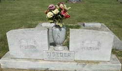
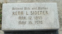
Rena L Sechrist Sidener
| Birth | : | 12 Mar 1895 Ada, Ottawa County, Kansas, USA |
| Death | : | 16 May 1978 Ada, Ottawa County, Kansas, USA |
| Burial | : | Greenwood Cemetery, Petoskey, Emmet County, USA |
| Coordinate | : | 45.3679276, -84.9753571 |
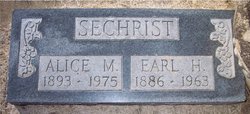
| Description | : | Rena L. Sidener, daughter of Wallace and Anna Sechrist, was born on a farm north of Ada, March 12, 1895. She went to be with her Lord on Tuesday, May 16, 1978 at the age of 83 years. Rena lived in the Ada community her entire life where she met and married Fred C. Sidener on August 5, 1913. She was preceded in death by her husband Fred, one brother Earl, and sisters Gladys, Gertie and Ida Pearl. Rena is survived by her daughter Mariana Mullen and son-in-law Eugene Mullen of Ada, two grandchildren Mike Mullen of Topeka and Mitzi of the... Read More |
frequently asked questions (FAQ):
-
Where is Rena L Sechrist Sidener's memorial?
Rena L Sechrist Sidener's memorial is located at: Greenwood Cemetery, Petoskey, Emmet County, USA.
-
When did Rena L Sechrist Sidener death?
Rena L Sechrist Sidener death on 16 May 1978 in Ada, Ottawa County, Kansas, USA
-
Where are the coordinates of the Rena L Sechrist Sidener's memorial?
Latitude: 45.3679276
Longitude: -84.9753571
Family Members:
Parent
Spouse

Siblings
Children
Flowers:


Nearby Cemetories:
1. Greenwood Cemetery
Petoskey, Emmet County, USA
Coordinate: 45.3679276, -84.9753571
2. Saint Francis Cemetery
Petoskey, Emmet County, USA
Coordinate: 45.3703130, -84.9799830
3. Saint Francis Solanus Indian Mission Cemetery
Petoskey, Emmet County, USA
Coordinate: 45.3753120, -84.9674140
4. Bay View Memorial Garden
Bay View, Emmet County, USA
Coordinate: 45.3865300, -84.9282900
5. Holy Childhood Indian Cemetery
Harbor Springs, Emmet County, USA
Coordinate: 45.4290656, -84.9910312
6. Holy Childhood of Jesus Cemetery
Harbor Springs, Emmet County, USA
Coordinate: 45.4387200, -84.9969500
7. Lakeview Cemetery
Harbor Springs, Emmet County, USA
Coordinate: 45.4403000, -84.9982986
8. North Bay Cemetery
Horton Bay, Charlevoix County, USA
Coordinate: 45.3208008, -85.0658035
9. Indian Cemetery
Petoskey, Emmet County, USA
Coordinate: 45.3563803, -85.0922168
10. Old Indian Cemetery
Resort Township, Emmet County, USA
Coordinate: 45.3563890, -85.0922220
11. Bear Creek Cemetery
Petoskey, Emmet County, USA
Coordinate: 45.3999914, -84.8611058
12. Sacramentine Monastery Cemetery
Petoskey, Emmet County, USA
Coordinate: 45.4102020, -84.8670610
13. Maple Hill Cemetery
Clarion, Charlevoix County, USA
Coordinate: 45.2803001, -84.9272003
14. Dunkard Cemetery
Walloon Lake, Charlevoix County, USA
Coordinate: 45.2774120, -84.9360000
15. Dyer Cemetery
Bay Township, Charlevoix County, USA
Coordinate: 45.2813988, -85.0556030
16. Little Traverse Township Cemetery
Harbor Springs, Emmet County, USA
Coordinate: 45.4357986, -84.8630981
17. Oak Lawn Cemetery
Bay Township, Charlevoix County, USA
Coordinate: 45.2914009, -85.0832977
18. Joy Valley Cemetery
Epsilon, Emmet County, USA
Coordinate: 45.3189011, -84.8191986
19. Evangeline Township Cemetery
Boyne City, Charlevoix County, USA
Coordinate: 45.2407990, -85.0188980
20. Undine Cemetery
Horton Bay, Charlevoix County, USA
Coordinate: 45.2858009, -85.1228027
21. Starr Cemetery
Stutsmanville, Emmet County, USA
Coordinate: 45.5075000, -84.9747220
22. Pleasantview Cemetery
Harbor Springs, Emmet County, USA
Coordinate: 45.5005989, -84.9132996
23. Curtiss Cemetery
Springvale Township, Emmet County, USA
Coordinate: 45.3736000, -84.7705994
24. Friendship Township Cemetery
Harbor Springs, Emmet County, USA
Coordinate: 45.5074997, -85.0366974