
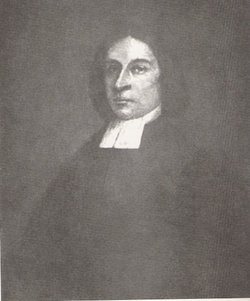


Rev Jared Eliot
| Birth | : | 7 Nov 1685 Guilford, New Haven County, Connecticut, USA |
| Death | : | 22 Apr 1763 Killingworth, Middlesex County, Connecticut, USA |
| Burial | : | West Grove Cemetery, Brush Creek Township, Jefferson County, USA |
| Coordinate | : | 40.5985985, -80.8613968 |
| Description | : | Son of Rev. Joseph Eliot and Mary Haynes (Wyllys) Eliot; husband of Hannah (Smithson) Eliot "Jared Eliot (November 7, 1685—April 22, 1763) was a farmer, minister and physician in Guilford, Connecticut who wrote several articles on agriculture and animal husbandry. Eliot was the eldest son of Joseph Eliot and his second wife, Mary Wyllys. The Eliots raised their family in Guilford (formerly known as Menunkatucket), which was settled by Europeans in 1639 ... Eliot’s essays were not widely accepted in New England until the 19th century. However, some contemporaries recognized his efforts to improve farming practices. Among those he inspired... Read More |
frequently asked questions (FAQ):
-
Where is Rev Jared Eliot's memorial?
Rev Jared Eliot's memorial is located at: West Grove Cemetery, Brush Creek Township, Jefferson County, USA.
-
When did Rev Jared Eliot death?
Rev Jared Eliot death on 22 Apr 1763 in Killingworth, Middlesex County, Connecticut, USA
-
Where are the coordinates of the Rev Jared Eliot's memorial?
Latitude: 40.5985985
Longitude: -80.8613968
Family Members:
Parent
Spouse
Siblings

Children
Flowers:


Nearby Cemetories:
1. West Grove Cemetery
Brush Creek Township, Jefferson County, USA
Coordinate: 40.5985985, -80.8613968
2. Dunbar Family Cemetery
Monroeville, Jefferson County, USA
Coordinate: 40.5878080, -80.8514680
3. Brush Creek Cemetery
Monroeville, Jefferson County, USA
Coordinate: 40.5978000, -80.8416900
4. Greenbrier-West Union Cemetery
Carroll County, USA
Coordinate: 40.5696983, -80.8728027
5. Woodland Cemetery
Salineville, Columbiana County, USA
Coordinate: 40.6278000, -80.8486023
6. Brush Creek Baptist Cemetery
Carroll County, USA
Coordinate: 40.5624008, -80.8715973
7. Saint Patricks Cemetery
Salineville, Columbiana County, USA
Coordinate: 40.6281013, -80.8311005
8. Ogle Cemetery
Washington Township, Columbiana County, USA
Coordinate: 40.6063995, -80.7778015
9. Russell Cemetery
Irondale, Jefferson County, USA
Coordinate: 40.5541992, -80.7869034
10. Dorn Cemetery
Bergholz, Jefferson County, USA
Coordinate: 40.5257988, -80.8625031
11. Chestnut Ridge Cemetery
Harlem Springs, Carroll County, USA
Coordinate: 40.5491982, -80.9336014
12. Corinth-Mechanicstown Cemetery
Mechanicstown, Carroll County, USA
Coordinate: 40.6156006, -80.9578018
13. Saint John's Catholic Cemetery
Summitville, Columbiana County, USA
Coordinate: 40.6722984, -80.8980026
14. Yellow Creek Cemetery
Bergholz, Jefferson County, USA
Coordinate: 40.5193740, -80.8438470
15. Mooretown Methodist Episcopal Cemetery
Ross Township, Jefferson County, USA
Coordinate: 40.5189200, -80.8391800
16. Scroggsfield Cemetery
Scroggsfield, Carroll County, USA
Coordinate: 40.5748980, -80.9652890
17. Chestnut Grove Cemetery
Irondale, Jefferson County, USA
Coordinate: 40.5733000, -80.7569600
18. Bergholz Cemetery
Bergholz, Jefferson County, USA
Coordinate: 40.5155983, -80.8955994
19. Clark Family Cemetery
Wellsville, Columbiana County, USA
Coordinate: 40.6114006, -80.7478027
20. Highlandtown Cemetery
Highlandtown, Columbiana County, USA
Coordinate: 40.6320000, -80.7549973
21. Seever Cemetery
Ross Township, Jefferson County, USA
Coordinate: 40.5233561, -80.7984235
22. Snyder Cemetery
Carroll County, USA
Coordinate: 40.6169014, -80.9766998
23. Bethel Presbyterian Church Cemetery
Salineville, Columbiana County, USA
Coordinate: 40.6607860, -80.7648250
24. Palmer Cemetery
Fox Township, Carroll County, USA
Coordinate: 40.5578003, -80.9764023