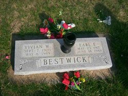
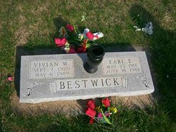
Rhonda Earlene Bestwick Trundle
| Birth | : | 28 Aug 1953 Gig Harbor, Pierce County, Washington, USA |
| Death | : | 11 Nov 2014 Reserve, Brown County, Kansas, USA |
| Burial | : | Cornelison Cemetery, Reserve, Brown County, USA |
| Coordinate | : | 39.9754105, -95.5485687 |
| Description | : | ******************************************* Rhonda E. Trundle, 61, of Reserve, KS, passed away November 11, 2014 at Falls City. She was born August 28, 1953 at Gig Harbor, WA to the late Earl and Vivian (Prosser) Bestwick. She married Jerry Sanders in 1972 and they were later divorced. She then married Ron Trundle on November 17, 1991 at Hiawatha, KS. Rhonda was raised in Reserve and graduated from the Hiawatha High School in 1971. She worked at Flarefold and then worked at Squaw Creek Truck Stop; she was a lifetime resident of Reserve. Her hobbies were gardening, camping, fishing and her... Read More |
frequently asked questions (FAQ):
-
Where is Rhonda Earlene Bestwick Trundle's memorial?
Rhonda Earlene Bestwick Trundle's memorial is located at: Cornelison Cemetery, Reserve, Brown County, USA.
-
When did Rhonda Earlene Bestwick Trundle death?
Rhonda Earlene Bestwick Trundle death on 11 Nov 2014 in Reserve, Brown County, Kansas, USA
-
Where are the coordinates of the Rhonda Earlene Bestwick Trundle's memorial?
Latitude: 39.9754105
Longitude: -95.5485687
Family Members:
Parent
Siblings
Flowers:
Nearby Cemetories:
1. Cornelison Cemetery
Reserve, Brown County, USA
Coordinate: 39.9754105, -95.5485687
2. Hart Cemetery
Reserve, Brown County, USA
Coordinate: 39.9519005, -95.5366974
3. Oakland Cemetery
Padonia, Brown County, USA
Coordinate: 39.9273900, -95.5610900
4. Laus Creek Cemetery
Reserve, Brown County, USA
Coordinate: 39.9754105, -95.4699936
5. Stumbo Cemetery
Brown County, USA
Coordinate: 39.9977798, -95.6298828
6. Pearson Point Cemetery
Falls City, Richardson County, USA
Coordinate: 40.0400800, -95.5688500
7. Nemaha Falls Cemetery
Richardson County, USA
Coordinate: 40.0313128, -95.6276913
8. Hamlin Cemetery
Hamlin, Brown County, USA
Coordinate: 39.9206009, -95.6292877
9. Pleasant Hill Cemetery
Hamlin, Brown County, USA
Coordinate: 39.9430428, -95.6484299
10. Falls City Cemetery
Falls City, Richardson County, USA
Coordinate: 40.0593987, -95.5569000
11. Pleasant Hill Cemetery
Irving Township, Brown County, USA
Coordinate: 39.9435997, -95.4328232
12. Saint Thomas Episcopal Church Columbarium
Falls City, Richardson County, USA
Coordinate: 40.0608500, -95.6016000
13. Falls City Pioneer Cemetery
Richardson County, USA
Coordinate: 40.0582500, -95.6156500
14. Zion Bethel Cemetery
Jefferson Township, Richardson County, USA
Coordinate: 40.0727997, -95.5017014
15. Steele Cemetery
Falls City, Richardson County, USA
Coordinate: 40.0675011, -95.6224976
16. Immaculate Conception Cemetery
Rulo, Richardson County, USA
Coordinate: 40.0480200, -95.4431800
17. Brethren Church Cemetery
Morrill, Brown County, USA
Coordinate: 39.9808693, -95.6940079
18. Niles Cemetery
Hiawatha, Brown County, USA
Coordinate: 39.8730900, -95.6126300
19. Shelton Cemetery
Hamlin, Brown County, USA
Coordinate: 39.8852997, -95.6393967
20. Rulo City Cemetery
Rulo, Richardson County, USA
Coordinate: 40.0561218, -95.4420471
21. Hiawatha Cemetery
Hiawatha, Brown County, USA
Coordinate: 39.8601799, -95.5265198
22. Campbell Cemetery
Reserve, Brown County, USA
Coordinate: 39.9905980, -95.3961750
23. Morrill Cemetery
Morrill, Brown County, USA
Coordinate: 39.9351311, -95.6932831
24. Herbster Cemetery
Falls City, Richardson County, USA
Coordinate: 40.0808700, -95.6184700


