


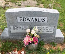
Rhonda Fay Tatum Edwards
| Birth | : | 18 Mar 1954 Savannah, Chatham County, Georgia, USA |
| Death | : | 8 Mar 2020 Mount Airy, Surry County, North Carolina, USA |
| Burial | : | Marion Cemetery, Cana, Carroll County, USA |
| Coordinate | : | 36.6055090, -80.7284550 |
| Description | : | Mrs. Rhonda Fay Tatum Edwards, 65, of Mt. Airy passed away Sunday, March 8, 2020, at Twelve Oaks Assisted Living in Mt. Airy. She was born in Savannah, GA, on March 18, 1954, to the late Harold and Fay Hodges Tatum. Mrs. Edwards' most recent job was a caregiver at a residence home where she shared her qualities of love, kindness, and compassion. Rhonda enjoyed reading, gardening, and traveling along the Blue Ridge Parkway enjoying nature. She is survived by her husband, Danny Edwards of the home; daughters... Read More |
frequently asked questions (FAQ):
-
Where is Rhonda Fay Tatum Edwards's memorial?
Rhonda Fay Tatum Edwards's memorial is located at: Marion Cemetery, Cana, Carroll County, USA.
-
When did Rhonda Fay Tatum Edwards death?
Rhonda Fay Tatum Edwards death on 8 Mar 2020 in Mount Airy, Surry County, North Carolina, USA
-
Where are the coordinates of the Rhonda Fay Tatum Edwards's memorial?
Latitude: 36.6055090
Longitude: -80.7284550
Family Members:
Parent
Spouse
Flowers:


Nearby Cemetories:
1. Nathaniel Samuel Jones Family Cemetery
Cana, Carroll County, USA
Coordinate: 36.6047060, -80.7186010
2. Frances Caroline Edwards Family Cemetery
Cana, Carroll County, USA
Coordinate: 36.6089000, -80.7193140
3. Sandy Ridge Primitive Baptist Church Cemetery
Cana, Carroll County, USA
Coordinate: 36.6089030, -80.7131890
4. George Jeremiah Edwards Family Cemetery
Cana, Carroll County, USA
Coordinate: 36.5937600, -80.7370100
5. Jones-Fleming Cemetery
Carroll County, USA
Coordinate: 36.6012360, -80.7114230
6. Flower Gap Primitive Baptist Church Cemetery
Cana, Carroll County, USA
Coordinate: 36.5900510, -80.7286500
7. Easter Family Cemetery
Carroll County, USA
Coordinate: 36.5900270, -80.7354860
8. Cedar Lane-Easter Cemetery
Cana, Carroll County, USA
Coordinate: 36.5898610, -80.7356070
9. Fancy Gap Pentecostal Holiness Church Cemetery
Cana, Carroll County, USA
Coordinate: 36.6227090, -80.7150880
10. King Cemetery
Cana, Carroll County, USA
Coordinate: 36.6170430, -80.7070900
11. Claucy William Hawks Family Cemetery
Cana, Carroll County, USA
Coordinate: 36.6236190, -80.7151980
12. Vernon-Leonard Cemetery
Cana, Carroll County, USA
Coordinate: 36.5841200, -80.7217600
13. Gray Cemetery
Cana, Carroll County, USA
Coordinate: 36.5943420, -80.7034040
14. McCraw Family Cemetery
Lambsburg, Carroll County, USA
Coordinate: 36.5814200, -80.7235270
15. Pauls Creek Baptist Church Cemetery
Cana, Carroll County, USA
Coordinate: 36.6072870, -80.6976360
16. King Family Cemetery
Cana, Carroll County, USA
Coordinate: 36.6211420, -80.7020900
17. King-Jones Cemetery
Cana, Carroll County, USA
Coordinate: 36.6224890, -80.7033540
18. Surratt Cemetery
Lambsburg, Carroll County, USA
Coordinate: 36.5790920, -80.7396730
19. Hawks Family Cemetery
Lambsburg, Carroll County, USA
Coordinate: 36.5960780, -80.7620250
20. Johnson-Leftwich Cemetery
Fancy Gap, Carroll County, USA
Coordinate: 36.6331620, -80.7381820
21. Edwards Cemetery
Cana, Carroll County, USA
Coordinate: 36.6154480, -80.6904890
22. Christopher W Jones Cemetery
Cana, Carroll County, USA
Coordinate: 36.5819178, -80.7000292
23. Rocky Ford Christian Church Cemetery
Cana, Carroll County, USA
Coordinate: 36.6080580, -80.6857110
24. Stockner Family Cemetery
Fancy Gap, Carroll County, USA
Coordinate: 36.6409450, -80.7429890