
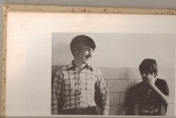
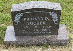
Richard Dale Tucker
| Birth | : | 2 Jan 1959 Thayer, Oregon County, Missouri, USA |
| Death | : | 28 Aug 2006 Thayer, Oregon County, Missouri, USA |
| Burial | : | Riverside Cemetery, Riceville, Mitchell County, USA |
| Coordinate | : | 43.3676834, -92.5576324 |
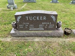
| Description | : | NOTE: Obituary gives burial as Arytown (Pleasant Hill); headstone is at New Salem with parents. Richard Dale Tucker, 47, of Thayer died at his home Aug. 28, 2006. He was born Jan. 2, 1959, in Thayer, MO, the son of Olon and Nevia Honeycutt Tucker. Tucker was a graduate of Thayer High School with the class of 1977. He was employed by the Sheltered Workshop in Alton since the beginning and truly enjoyed going to work each day and cherished the many friends he worked with. He will be missed by his family and many friends. Survivors include his mother, Nevia Tucker of the... Read More |
frequently asked questions (FAQ):
-
Where is Richard Dale Tucker's memorial?
Richard Dale Tucker's memorial is located at: Riverside Cemetery, Riceville, Mitchell County, USA.
-
When did Richard Dale Tucker death?
Richard Dale Tucker death on 28 Aug 2006 in Thayer, Oregon County, Missouri, USA
-
Where are the coordinates of the Richard Dale Tucker's memorial?
Latitude: 43.3676834
Longitude: -92.5576324
Family Members:
Parent

Flowers:


Nearby Cemetories:
1. Calvary Cemetery
Riceville, Mitchell County, USA
Coordinate: 43.3497009, -92.5550003
2. Saint Peters Lutheran Cemetery
Riceville, Mitchell County, USA
Coordinate: 43.3163986, -92.5547028
3. Wayne Cemetery
McIntire, Mitchell County, USA
Coordinate: 43.4411011, -92.5744019
4. Beaver Creek Cemetery
Brownville, Mitchell County, USA
Coordinate: 43.3397217, -92.6727829
5. Robbins Cemetery
David (historical), Mitchell County, USA
Coordinate: 43.4150009, -92.6718979
6. Reckner Cemetery
Howard County, USA
Coordinate: 43.2743988, -92.5152969
7. Saint Peters Cemetery
New Haven, Mitchell County, USA
Coordinate: 43.2858315, -92.6427765
8. Saratoga Township Cemetery
Saratoga, Howard County, USA
Coordinate: 43.3710000, -92.4023000
9. Saint Pauls Lutheran Church Cemetery
Maple Leaf, Howard County, USA
Coordinate: 43.3217000, -92.4082000
10. Liberty Cemetery
Little Cedar, Mitchell County, USA
Coordinate: 43.3856010, -92.7230988
11. Saint Patricks Church Cemetery
McIntire, Mitchell County, USA
Coordinate: 43.4771996, -92.6508026
12. Sacred Heart Cemetery
Meyer, Mitchell County, USA
Coordinate: 43.4583282, -92.7011108
13. Calvary Cemetery
Elma, Howard County, USA
Coordinate: 43.2522011, -92.4421997
14. Howard Cemetery
Elma, Howard County, USA
Coordinate: 43.2517014, -92.4372025
15. Saint Patricks Cemetery
Howard County, USA
Coordinate: 43.2200012, -92.5149994
16. Le Roy Cemetery
Le Roy, Mower County, USA
Coordinate: 43.5214005, -92.5227966
17. Saint Patricks Cemetery
Le Roy, Mower County, USA
Coordinate: 43.5217018, -92.5207977
18. Le Roy Lutheran Cemetery
Le Roy, Mower County, USA
Coordinate: 43.5217750, -92.5196340
19. Chester Hill Cemetery
Chester, Howard County, USA
Coordinate: 43.4897003, -92.4072037
20. Stillwater Cemetery
Orchard, Mitchell County, USA
Coordinate: 43.2130585, -92.6780624
21. Visitation Catholic Cemetery
Stacyville, Mitchell County, USA
Coordinate: 43.4430618, -92.7813873
22. Stacyville Cemetery
Stacyville, Mitchell County, USA
Coordinate: 43.4294014, -92.7908020
23. Sacred Heart Cemetery
Osage, Mitchell County, USA
Coordinate: 43.2742004, -92.7917023
24. Calvary Cemetery
Alta Vista, Chickasaw County, USA
Coordinate: 43.1983520, -92.4241590