
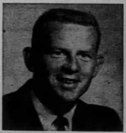
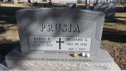
Richard Garrett “Dick” Prusia
| Birth | : | 26 May 1936 Franklin, Franklin County, Nebraska, USA |
| Death | : | 1 Jan 2013 Gordon, Sheridan County, Nebraska, USA |
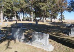
| Burial | : | Gordon Cemetery, Gordon, Sheridan County, USA |
| Coordinate | : | 42.7858009, -102.2102966 |
| Description | : | Richard Garrett Prusia May 26,1936-Jan 1,2013 Richard Garrett Prusia, 76, died Tuesday, Jan. 1, 2013 at Gordon. Services were held at Grace Lutheran Church in Gordon with inurnment at the Gordon Cemetery. A memorial has been established at Bank of the West in Gordon.Dick was born May 26, 1936 in Franklin, Neb. to Clarence and Elizabeth Garrett Prusia, the youngest of eight children. He graduated from Franklin High School in 1954, and attended the University of Nebraska-Lincoln, where he played football for the Nebraska Cornhuskers. He graduated from UNL in 1958 and moved to Gordon, where he met and was then... Read More |
frequently asked questions (FAQ):
-
Where is Richard Garrett “Dick” Prusia's memorial?
Richard Garrett “Dick” Prusia's memorial is located at: Gordon Cemetery, Gordon, Sheridan County, USA.
-
When did Richard Garrett “Dick” Prusia death?
Richard Garrett “Dick” Prusia death on 1 Jan 2013 in Gordon, Sheridan County, Nebraska, USA
-
Where are the coordinates of the Richard Garrett “Dick” Prusia's memorial?
Latitude: 42.7858009
Longitude: -102.2102966
Family Members:
Parent

Siblings
Flowers:


Nearby Cemetories:
1. Gordon Cemetery
Gordon, Sheridan County, USA
Coordinate: 42.7858009, -102.2102966
2. Mount Hope Cemetery
Gordon, Sheridan County, USA
Coordinate: 42.7113991, -102.2241974
3. Dane Cemetery
Cherry County, USA
Coordinate: 42.7924300, -102.0824700
4. Bethel Cemetery
Sheridan County, USA
Coordinate: 42.9011002, -102.3208008
5. Lavaca Cemetery
Irwin, Cherry County, USA
Coordinate: 42.7332993, -102.0175018
6. Amity Cemetery
Sheridan County, USA
Coordinate: 42.8036003, -102.4389038
7. Fair View Cemetery
Rushville, Sheridan County, USA
Coordinate: 42.7155991, -102.4325027
8. Saint Aloysius Cemetery
Sheridan County, USA
Coordinate: 42.9015500, -102.4025500
9. Saint Marys Cemetery
Rushville, Sheridan County, USA
Coordinate: 42.7174988, -102.4436035
10. Feather on Head Cemetery
Oglala Lakota County, USA
Coordinate: 43.0311012, -102.1611023
11. Holly Cemetery
Rushville, Sheridan County, USA
Coordinate: 42.8575120, -102.5370990
12. Novotny Cemetery
Hay Springs, Sheridan County, USA
Coordinate: 42.7742004, -102.5963974
13. Davis Cemetery
Rushville, Sheridan County, USA
Coordinate: 42.5421000, -102.4118800
14. Wolf Creek Community Cemetery
Oglala Lakota County, USA
Coordinate: 43.0405750, -102.3966490
15. Spotted Bear Family Cemetery
Denby, Oglala Lakota County, USA
Coordinate: 43.0608200, -102.3376600
16. Preble Cemetery
Sheridan County, USA
Coordinate: 42.6504000, -102.5765000
17. Abold Family Cemetery
Rushville, Sheridan County, USA
Coordinate: 42.8863500, -102.6158000
18. Bomar Cemetery
Hay Springs, Sheridan County, USA
Coordinate: 42.8062000, -102.6459600
19. Native American Cemetery
Oglala, Oglala Lakota County, USA
Coordinate: 43.0886002, -102.3550034
20. White Clay Cemetery
Rushville, Sheridan County, USA
Coordinate: 42.9732820, -102.5667230
21. Knight Cemetery
Oglala Lakota County, USA
Coordinate: 43.1039009, -102.1200027
22. Holy Cross Cemetery
Pine Ridge, Oglala Lakota County, USA
Coordinate: 43.0194016, -102.5503006
23. Pine Ridge Presbyterian Cemetery
Pine Ridge, Oglala Lakota County, USA
Coordinate: 43.0235200, -102.5506200
24. Beguin Cemetery
Sheridan County, USA
Coordinate: 42.5107994, -102.4982986