

Robert Albert Wilson
| Birth | : | 1874 Lanark County, Ontario, Canada |
| Death | : | 24 May 1961 Perth, Lanark County, Ontario, Canada |
| Burial | : | All Saints Churchyard, Moddershall, Stafford Borough, England |
| Coordinate | : | 52.9296310, -2.1126940 |
| Plot | : | 152 |
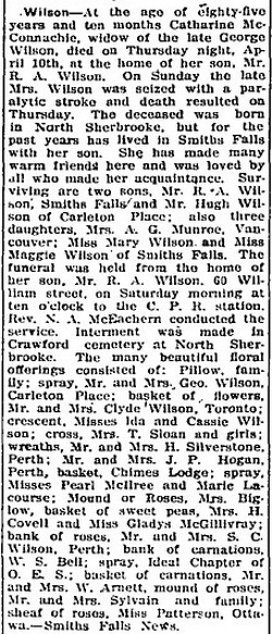
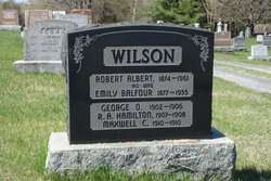
| Description | : | Robert was born in Lanark County, Ontario, the son of George Wilson and Catherine McConnachie. He was married at Elphin, Ontario on January 29,1901 to Emily Balfour, daughter of Robert Balfour and Agnes Lockhart. Robert died at Perth, Ontario on May 24,1961. ------------------------------------ Plot 152 : - Robert Albert Wilson 1874-1961. - his wife, Emily Balfour 1877-1955. - George O. Wilson 1902-1906. - R. A. Hamilton Wilson 1907-1908. - Maxwell C. Wilson 1910-1910. ------------------------------------ Death - The Perth Courier - June 1, 1961 - Wilson - Robert Albert, at Perth, Ont., on Wednesday, May 24th, 1961, Robert Albert Wilson, beloved husband of the late Emmeline Balfour, age 87 years. Resting... Read More |
frequently asked questions (FAQ):
-
Where is Robert Albert Wilson's memorial?
Robert Albert Wilson's memorial is located at: All Saints Churchyard, Moddershall, Stafford Borough, England.
-
When did Robert Albert Wilson death?
Robert Albert Wilson death on 24 May 1961 in Perth, Lanark County, Ontario, Canada
-
Where are the coordinates of the Robert Albert Wilson's memorial?
Latitude: 52.9296310
Longitude: -2.1126940
Family Members:
Parent
Spouse
Siblings


Children


Flowers:


Nearby Cemetories:
1. All Saints Churchyard
Moddershall, Stafford Borough, England
Coordinate: 52.9296310, -2.1126940
2. St John the Evangelist
Oulton, Stafford Borough, England
Coordinate: 52.9159400, -2.1330400
3. St Dominic's Convent Churchyard
Stone, Stafford Borough, England
Coordinate: 52.9106500, -2.1407000
4. St Nicholas Churchyard
Fulford, Stafford Borough, England
Coordinate: 52.9428060, -2.0722970
5. Barlaston Cemetery
Barlaston, Stafford Borough, England
Coordinate: 52.9433490, -2.1537310
6. Christ Church Churchyard
Hilderstone, Stafford Borough, England
Coordinate: 52.9100990, -2.0755470
7. Christ Church Churchyard
Stone, Stafford Borough, England
Coordinate: 52.9042670, -2.1477510
8. St. Michael and St. Wulfad Churchyard
Stone, Stafford Borough, England
Coordinate: 52.9016030, -2.1433420
9. Stone Priory
Stone, Stafford Borough, England
Coordinate: 52.9013610, -2.1441120
10. Stone Cemetery
Stone, Stafford Borough, England
Coordinate: 52.8874860, -2.1369430
11. St Saviour Churchyard
Aston-by-Stone, Stafford Borough, England
Coordinate: 52.8841410, -2.1283140
12. St Luke Churchyard
Tittensor, Stafford Borough, England
Coordinate: 52.9407830, -2.1889820
13. St Peter Churchyard
Forsbrook, Staffordshire Moorlands District, England
Coordinate: 52.9675780, -2.0593040
14. Resurrection Churchyard
Dresden, Stoke-on-Trent Unitary Authority, England
Coordinate: 52.9781480, -2.1317140
15. St. Bartholomews Churchyard
Stoke-on-Trent Unitary Authority, England
Coordinate: 52.9743050, -2.1519670
16. Longton Garden of Remembrance
Longton, Stoke-on-Trent Unitary Authority, England
Coordinate: 52.9831560, -2.1359530
17. Longton Cemetery
Longton, Stoke-on-Trent Unitary Authority, England
Coordinate: 52.9833150, -2.1380000
18. St. James the Less Churchyard
Longton, Stoke-on-Trent Unitary Authority, England
Coordinate: 52.9854360, -2.1291320
19. St. Paul's Cemetery
Longton, Stoke-on-Trent Unitary Authority, England
Coordinate: 52.9840874, -2.1408574
20. St Peter Churchyard
Caverswall, Staffordshire Moorlands District, England
Coordinate: 52.9824410, -2.0733810
21. St. Margaret Churchyard
Draycott, Staffordshire Moorlands District, England
Coordinate: 52.9594640, -2.0297030
22. All Saints Churchyard
Milwich, Stafford Borough, England
Coordinate: 52.8852590, -2.0443610
23. Trentham Cemetery
Trentham, Stoke-on-Trent Unitary Authority, England
Coordinate: 52.9665640, -2.1980300
24. Britannia Stadium
Stoke-on-Trent, Stoke-on-Trent Unitary Authority, England
Coordinate: 52.9884070, -2.1754520