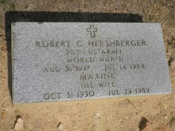
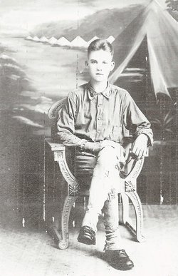
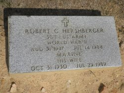
Robert Gerstell Hershberger Jr.
| Birth | : | 31 Aug 1927 Lonaconing, Allegany County, Maryland, USA |
| Death | : | 14 Jul 1984 Barton, Allegany County, Maryland, USA |
| Burial | : | West Union Cemetery, Traer, Tama County, USA |
| Coordinate | : | 42.1817017, -92.4449997 |
| Plot | : | SECTION K-4 ROW 8 SITE 11 |
| Description | : | HERSHBERGER, ROBERT G JR SGT US ARMY WORLD WAR II DATE OF BIRTH: 08/31/1927 DATE OF DEATH: 07/14/1984 BURIED AT: SECTION K-4 ROW 8 SITE 11 |
frequently asked questions (FAQ):
-
Where is Robert Gerstell Hershberger Jr.'s memorial?
Robert Gerstell Hershberger Jr.'s memorial is located at: West Union Cemetery, Traer, Tama County, USA.
-
When did Robert Gerstell Hershberger Jr. death?
Robert Gerstell Hershberger Jr. death on 14 Jul 1984 in Barton, Allegany County, Maryland, USA
-
Where are the coordinates of the Robert Gerstell Hershberger Jr.'s memorial?
Latitude: 42.1817017
Longitude: -92.4449997
Family Members:
Parent
Spouse
Siblings
Nearby Cemetories:
1. West Union Cemetery
Traer, Tama County, USA
Coordinate: 42.1817017, -92.4449997
2. Saint Pauls Catholic Cemetery
Traer, Tama County, USA
Coordinate: 42.1832000, -92.4688000
3. Buckingham Cemetery
Traer, Tama County, USA
Coordinate: 42.2069016, -92.4741974
4. Bakers Grove Cemetery
Traer, Tama County, USA
Coordinate: 42.1319008, -92.5143967
5. Larch Hill Cemetery
Buckingham, Tama County, USA
Coordinate: 42.2638701, -92.4524057
6. Oneida Cemetery
Clutier, Tama County, USA
Coordinate: 42.1007996, -92.3966980
7. Dinsdale Cemetery
Tama County, USA
Coordinate: 42.2472000, -92.5330963
8. Saint Wenceslaus Cemetery
Clutier, Tama County, USA
Coordinate: 42.0870000, -92.4460000
9. Dysart Cemetery
Dysart, Tama County, USA
Coordinate: 42.1608009, -92.3193970
10. Saint Josephs Catholic Cemetery
Benton County, USA
Coordinate: 42.1719017, -92.2981033
11. Clutier Cemetery
Clutier, Tama County, USA
Coordinate: 42.0792007, -92.3858032
12. Spencer Cemetery
Dysart, Tama County, USA
Coordinate: 42.2592120, -92.3353840
13. Pleasant Hill Cemetery
Toledo, Tama County, USA
Coordinate: 42.1080000, -92.5595000
14. Geneseo Cemetery
Buckingham, Tama County, USA
Coordinate: 42.2764370, -92.3523950
15. Hill Cemetery
Tama County, USA
Coordinate: 42.2542000, -92.3075027
16. Brown Bruce Township Cemetery
Benton County, USA
Coordinate: 42.2163430, -92.2799680
17. Fee Chapel Cemetery
Tama County, USA
Coordinate: 42.0643997, -92.5117035
18. Blessing Cemetery
Hudson, Black Hawk County, USA
Coordinate: 42.3116700, -92.4572200
19. Grant Township Cemetery
Grant Township, Tama County, USA
Coordinate: 42.2571983, -92.5922012
20. Rampton Cemetery
Monroe Township, Benton County, USA
Coordinate: 42.1866989, -92.2605972
21. Roadside Cemetery
Clutier, Tama County, USA
Coordinate: 42.0574800, -92.3548800
22. Crystal Township Cemetery
Garwin, Tama County, USA
Coordinate: 42.1380997, -92.6264038
23. Houghton Cemetery
Benton County, USA
Coordinate: 42.1088982, -92.2794037
24. Lone Pine Cemetery
Tama County, USA
Coordinate: 42.0797005, -92.3082962


