
Robert “Red” Compton
| Birth | : | 8 Nov 1931 Redfield, Spink County, South Dakota, USA |
| Death | : | 29 Oct 2014 Pierre, Hughes County, South Dakota, USA |
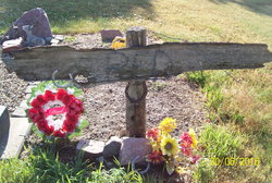
| Burial | : | Scotty Philip Cemetery, Fort Pierre, Stanley County, USA |
| Coordinate | : | 44.4019012, -100.4036026 |
| Plot | : | Section 2 Lot 169 Grave 2 |
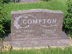
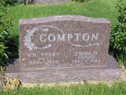
| Description | : | Robert “Red” Compton, 82 of Ft. Pierre, died Wednesday, October 29 at Golden Living Center in Pierre. Robert was born on November 8, 1931 to William Perry Compton and Emma Oceshle in Redfield. He attended school in Redfield where he excelled in baseball and football. He graduated in 1950 and left for the Navy the next day. He was united in marriage to MaryLou Newman on October 18, 1951. To this union four children were born. In 1952 he attended Dunwoody Institute in Minneapolis to study welding, working for the railroad to put himself through school. Robert joined the Boilermakers Union as... Read More |
frequently asked questions (FAQ):
-
Where is Robert “Red” Compton's memorial?
Robert “Red” Compton's memorial is located at: Scotty Philip Cemetery, Fort Pierre, Stanley County, USA.
-
When did Robert “Red” Compton death?
Robert “Red” Compton death on 29 Oct 2014 in Pierre, Hughes County, South Dakota, USA
-
Where are the coordinates of the Robert “Red” Compton's memorial?
Latitude: 44.4019012
Longitude: -100.4036026
Family Members:
Parent
Siblings
Children
Flowers:


Nearby Cemetories:
1. Scotty Philip Cemetery
Fort Pierre, Stanley County, USA
Coordinate: 44.4019012, -100.4036026
2. Fort Pierre Chouteau Cemetery
Fort Pierre, Stanley County, USA
Coordinate: 44.3908700, -100.3878300
3. Mount Calvary Cemetery
Pierre, Hughes County, USA
Coordinate: 44.4197006, -100.3557968
4. South Dakota State Capitol Grounds
Pierre, Hughes County, USA
Coordinate: 44.3660100, -100.3448000
5. Cedar Hill Cemetery
Fort Pierre, Stanley County, USA
Coordinate: 44.3356018, -100.3964005
6. Riverside Cemetery
Pierre, Hughes County, USA
Coordinate: 44.3608017, -100.3071976
7. Byron Township Cemetery
Blunt, Hughes County, USA
Coordinate: 44.4979200, -100.1904700
8. Fort Sully Post Cemetery
Sully County, USA
Coordinate: 44.5866480, -100.6087530
9. Meers Cemetery
Stanley County, USA
Coordinate: 44.4116970, -100.7360760
10. Mathews Family Cemetery
Stanley County, USA
Coordinate: 44.1816040, -100.5581080
11. Okobojo Cemetery
Sully County, USA
Coordinate: 44.6568985, -100.3647003
12. Canning Cemetery
Hughes County, USA
Coordinate: 44.3986890, -100.0278460
13. Holy Name Episcopal Cemetery
Fort Pierre, Stanley County, USA
Coordinate: 44.2694960, -100.0357300
14. Holy Name Chapel Cemetery
Fort Pierre, Stanley County, USA
Coordinate: 44.2694292, -100.0356989
15. Pleasant Hill Cemetery
Blunt, Hughes County, USA
Coordinate: 44.5135994, -100.0156021
16. Fort Bennett Post Cemetery
Stanley County, USA
Coordinate: 44.6716500, -100.6404200
17. Immanuel Lutheran Cemetery
Van Metre, Jones County, USA
Coordinate: 44.0958800, -100.7263300
18. Mission Ridge Cemetery
Mission Ridge, Stanley County, USA
Coordinate: 44.6960983, -100.7716980
19. Onida Cemetery
Onida, Sully County, USA
Coordinate: 44.7147000, -100.0650000
20. Chapelle Cemetery
Hughes County, USA
Coordinate: 44.3025017, -99.8653030
21. Holy Faith Cemetery
Lyman County, USA
Coordinate: 44.1356010, -99.9878006
22. Blair Cemetery
Sully County, USA
Coordinate: 44.8027992, -100.4199982
23. Sansarc Cemetery
Hayes, Stanley County, USA
Coordinate: 44.5153008, -101.0342026
24. Draper Cemetery
Draper, Jones County, USA
Coordinate: 43.9322014, -100.5475006