
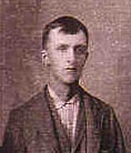
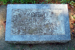
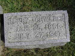
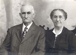
Robert Thomas “Rob” Schwark
| Birth | : | 4 Sep 1874 Melrose Township, Grundy County, Iowa, USA |
| Death | : | 30 Dec 1954 USA |
| Burial | : | St. Cuthbert's Churchyard, Beltingham, Northumberland Unitary Authority, England |
| Coordinate | : | 54.9694330, -2.3305080 |
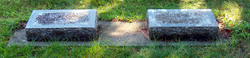
| Plot | : | Lot 226 |
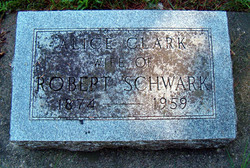
| Description | : | Rob was the son of John & Hannah Schwarck. He married Alice Clark on January 18, 1905. |
frequently asked questions (FAQ):
-
Where is Robert Thomas “Rob” Schwark's memorial?
Robert Thomas “Rob” Schwark's memorial is located at: St. Cuthbert's Churchyard, Beltingham, Northumberland Unitary Authority, England.
-
When did Robert Thomas “Rob” Schwark death?
Robert Thomas “Rob” Schwark death on 30 Dec 1954 in USA
-
Where are the coordinates of the Robert Thomas “Rob” Schwark's memorial?
Latitude: 54.9694330
Longitude: -2.3305080
Family Members:
Parent
Spouse
Siblings

Children
Flowers:


Nearby Cemetories:
1. St. Cuthbert's Churchyard
Beltingham, Northumberland Unitary Authority, England
Coordinate: 54.9694330, -2.3305080
2. Beltingham Cemetery
Beltingham, Northumberland Unitary Authority, England
Coordinate: 54.9690700, -2.3312200
3. All Hallows Churchyard
Henshaw, Northumberland Unitary Authority, England
Coordinate: 54.9731030, -2.3704408
4. St Cuthbert Churchyard
Haydon Bridge, Northumberland Unitary Authority, England
Coordinate: 54.9740620, -2.2473570
5. Haydon Bridge Churchyard Extension
Haydon Bridge, Northumberland Unitary Authority, England
Coordinate: 54.9766250, -2.2478820
6. Haydon Bridge Cemetery
Haydon Bridge, Northumberland Unitary Authority, England
Coordinate: 54.9694700, -2.2467715
7. Haydon Old Churchyard
Haydon Bridge, Northumberland Unitary Authority, England
Coordinate: 54.9818710, -2.2483010
8. Keenley Methodist Chapel Graveyard
Allendale, Northumberland Unitary Authority, England
Coordinate: 54.9053170, -2.3075580
9. Cowburn Primitive Methodist Chapel
Cowburn, Northumberland Unitary Authority, England
Coordinate: 55.0034880, -2.4323380
10. Holy Cross Churchyard
Haltwhistle, Northumberland Unitary Authority, England
Coordinate: 54.9699900, -2.4583480
11. Haltwhistle Cemetery
Haltwhistle, Northumberland Unitary Authority, England
Coordinate: 54.9652600, -2.4740100
12. St. Cuthbert's Churchyard
Allendale, Northumberland Unitary Authority, England
Coordinate: 54.8978260, -2.2545020
13. Friends Meeting House
Allendale, Northumberland Unitary Authority, England
Coordinate: 54.8957750, -2.2598490
14. Friends Meeting House Cemetery
Coanwood, Northumberland Unitary Authority, England
Coordinate: 54.9241920, -2.4540450
15. High House Methodist Chapel Graveyard
Allendale, Northumberland Unitary Authority, England
Coordinate: 54.8844090, -2.3285218
16. Allendale Old Cemetery
Allendale, Northumberland Unitary Authority, England
Coordinate: 54.8941650, -2.2612690
17. Allendale Woodland Cemetery
Allendale, Northumberland Unitary Authority, England
Coordinate: 54.8932624, -2.2618136
18. St Mary & St Patrick Churchyard
Lambley, Northumberland Unitary Authority, England
Coordinate: 54.9209060, -2.5122140
19. St Cuthbert's Churchyard
Greenhead, Northumberland Unitary Authority, England
Coordinate: 54.9813930, -2.5324120
20. St Andrew's Cemetery
Haydon Bridge, Northumberland Unitary Authority, England
Coordinate: 54.9788680, -2.1276850
21. Hexham Cemetery
Hexham, Northumberland Unitary Authority, England
Coordinate: 54.9788580, -2.1276740
22. Limestone Brae Burial Ground
Allendale, Northumberland Unitary Authority, England
Coordinate: 54.8441180, -2.3233520
23. Limestone Brae, Wesleyan Methodist Chapel
Allendale, Northumberland Unitary Authority, England
Coordinate: 54.8425890, -2.3207386
24. St John of Beverley Churchyard
Acomb, Northumberland Unitary Authority, England
Coordinate: 54.9859680, -2.1061560