
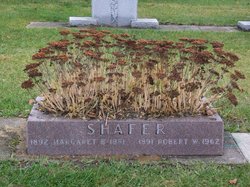
Robert Wiltfong Shafer
| Birth | : | 14 Oct 1891 Rochester, Fulton County, Indiana, USA |
| Death | : | 1 Feb 1962 Rochester Township, Fulton County, Indiana, USA |
| Burial | : | Eltham Cemetery, Eltham, South Taranaki District, New Zealand |
| Coordinate | : | -39.4197140, 174.3251260 |
| Plot | : | Section 15, Row 5 |
| Description | : | Published in The Rochester News-Sentinel Thursday, February 1, 1962 Robert W. Shafer Robert Wiltfong SHAFER, 70, for years a prominent public official, died at his home, 1012 Pontiac street, at 2:40 a.m. today. Cause of death was arteriosclerosis followed by uremic poisoning. He suffered from the disease for the last two years and became seriously ill four months ago. He had livd in Fulton county all his life except one year in Chicago and a year in Bradenton, Fla. In 1933, he launched a uniquely successful political career, holding offices for 22 years, last serving as mayor of Rochester from 1952 through 1955. During his... Read More |
frequently asked questions (FAQ):
-
Where is Robert Wiltfong Shafer's memorial?
Robert Wiltfong Shafer's memorial is located at: Eltham Cemetery, Eltham, South Taranaki District, New Zealand.
-
When did Robert Wiltfong Shafer death?
Robert Wiltfong Shafer death on 1 Feb 1962 in Rochester Township, Fulton County, Indiana, USA
-
Where are the coordinates of the Robert Wiltfong Shafer's memorial?
Latitude: -39.4197140
Longitude: 174.3251260
Family Members:
Parent


Spouse

Siblings
Children
Flowers:


Nearby Cemetories:
1. Eltham Cemetery
Eltham, South Taranaki District, New Zealand
Coordinate: -39.4197140, 174.3251260
2. Kopuatama Cemetery
Stratford, Stratford District, New Zealand
Coordinate: -39.3364400, 174.3364500
3. Pioneer Cemetery
Stratford, Stratford District, New Zealand
Coordinate: -39.3359800, 174.2929000
4. Te Utinga Urupā
Normanby, South Taranaki District, New Zealand
Coordinate: -39.5330847, 174.2761055
5. Weri Weri Urupa Aotearoa Marae
Okaiawa, South Taranaki District, New Zealand
Coordinate: -39.5190700, 174.2206700
6. Te Ngutu o te Manu Battlesite Memorial
Kapuni, South Taranaki District, New Zealand
Coordinate: -39.4876351, 174.1838147
7. Kaponga Cemetery
Kaponga, South Taranaki District, New Zealand
Coordinate: -39.4312210, 174.1553160
8. Midhirst Old Cemetery
Midhirst, Stratford District, New Zealand
Coordinate: -39.2911920, 174.2731980
9. Midhirst Cemetery
Midhirst, Stratford District, New Zealand
Coordinate: -39.2913640, 174.2724620
10. Waihi Cemetery and Redoubt
Normanby, South Taranaki District, New Zealand
Coordinate: -39.5444930, 174.2566820
11. Okaiawa Cemetery
Okaiawa, South Taranaki District, New Zealand
Coordinate: -39.5310220, 174.2042180
12. Tiwhaiti Urupa (Taiporohenui Marae)
Hāwera, South Taranaki District, New Zealand
Coordinate: -39.5741843, 174.3216120
13. Hāwera Cemetery
Hāwera, South Taranaki District, New Zealand
Coordinate: -39.5897900, 174.2945500
14. Motuawa Urupā Waiokura Marae
Manaia, South Taranaki District, New Zealand
Coordinate: -39.5388010, 174.1438990
15. Ohawe Military Cemetery
Ohawe Beach, South Taranaki District, New Zealand
Coordinate: -39.5835138, 174.2003758
16. Manaia Redoubt
Manaia, South Taranaki District, New Zealand
Coordinate: -39.5461557, 174.1364306
17. Manaia Cemetery
Manaia, South Taranaki District, New Zealand
Coordinate: -39.5575010, 174.1354470
18. Manutahi Cemetery
Manutahi, South Taranaki District, New Zealand
Coordinate: -39.6594677, 174.3924181
19. Tarata Cemetery
Tarata, New Plymouth District, New Zealand
Coordinate: -39.1496000, 174.3658200
20. Inglewood Cemetery
Inglewood, New Plymouth District, New Zealand
Coordinate: -39.1554140, 174.2145930
21. Otakeho Cemetery
New Plymouth, New Plymouth District, New Zealand
Coordinate: -39.5492080, 174.0051880
22. Purangi Cemetery
Purangi, New Plymouth District, New Zealand
Coordinate: -39.1571550, 174.5287180
23. Pihama Cemetery
Pihama, South Taranaki District, New Zealand
Coordinate: -39.5075300, 173.9285600
24. Mangapouri Cemetery
Egmont Village, New Plymouth District, New Zealand
Coordinate: -39.1347278, 174.1282396