
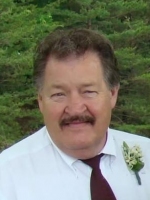
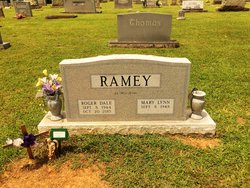
Roger Dale Ramey
| Birth | : | 8 Sep 1944 Franklin, Surry County, North Carolina, USA |
| Death | : | 20 Oct 2015 Dobson, Surry County, North Carolina, USA |
| Burial | : | Epworth United Methodist Church Cemetery, Cana, Carroll County, USA |
| Coordinate | : | 36.5736110, -80.6536110 |
| Description | : | Mr. Roger Dale Ramey, 71 of Mt. Airy passed away at the Joan and Howard Hospice Home on Tuesday, October 20, 2015. He was born in Surry County on September 8, 1944 to the late Letcher and Stella Doby Ramey. Mr. Ramey attended North Surry High School and retired from Proctor Silex after 38 years of service. After retirement he worked at Life Span and Northwest Medical Partners until his health no longer permitted him to continue. Mr. Ramey served as past president of the Beulah Ruritan Club and was one of the founding members of Skull Camp Fire Department... Read More |
frequently asked questions (FAQ):
-
Where is Roger Dale Ramey's memorial?
Roger Dale Ramey's memorial is located at: Epworth United Methodist Church Cemetery, Cana, Carroll County, USA.
-
When did Roger Dale Ramey death?
Roger Dale Ramey death on 20 Oct 2015 in Dobson, Surry County, North Carolina, USA
-
Where are the coordinates of the Roger Dale Ramey's memorial?
Latitude: 36.5736110
Longitude: -80.6536110
Family Members:
Parent

Siblings
Flowers:


Nearby Cemetories:
1. Epworth United Methodist Church Cemetery
Cana, Carroll County, USA
Coordinate: 36.5736110, -80.6536110
2. A.L. Jones Family Cemetery
Cana, Carroll County, USA
Coordinate: 36.5754410, -80.6561640
3. Speas Family Cemetery
Cana, Carroll County, USA
Coordinate: 36.5724564, -80.6447983
4. Westmoreland Cemetery
Cana, Carroll County, USA
Coordinate: 36.5850100, -80.6461990
5. Solid Rock Baptist Church Cemetery
Cana, Carroll County, USA
Coordinate: 36.5652400, -80.6357650
6. Glass Family Memorial Cemetery
Cana, Carroll County, USA
Coordinate: 36.5652280, -80.6357090
7. Oak Ridge Baptist Church Cemetery
Cana, Carroll County, USA
Coordinate: 36.5718760, -80.6800790
8. Flat Ridge Baptist Church Cemetery
Cana, Carroll County, USA
Coordinate: 36.5867470, -80.6298910
9. Cana Baptist Church Cemetery
Cana, Carroll County, USA
Coordinate: 36.5920764, -80.6717347
10. Primitive Baptist Church Of Jesus Christ Cemetery
Cana, Carroll County, USA
Coordinate: 36.5917320, -80.6737210
11. Wisler Cemetery
Cana, Carroll County, USA
Coordinate: 36.5933240, -80.6756550
12. Mount Carmel Baptist Church Cemetery
Mount Airy, Surry County, USA
Coordinate: 36.5432510, -80.6457214
13. State Line Primitive Baptist Church Cemetery
Mount Airy, Surry County, USA
Coordinate: 36.5580000, -80.6117220
14. Mount Bethel Moravian Graveyard
Cana, Carroll County, USA
Coordinate: 36.6053120, -80.6272700
15. Christopher W Jones Cemetery
Cana, Carroll County, USA
Coordinate: 36.5819178, -80.7000292
16. Rocky Ford Christian Church Cemetery
Cana, Carroll County, USA
Coordinate: 36.6080580, -80.6857110
17. Zion United Methodist Cemetery
Mount Airy, Surry County, USA
Coordinate: 36.5326958, -80.6725845
18. New Bethel Baptist South
Mount Airy, Surry County, USA
Coordinate: 36.5533870, -80.7018270
19. New Bethel Baptist Church Cemetery
Mount Airy, Surry County, USA
Coordinate: 36.5535920, -80.7020960
20. James Harding Golding Family Cemetery
Mount Airy, Surry County, USA
Coordinate: 36.5539500, -80.7023900
21. Booker-Busick-Smith Cemetery
Mount Airy, Surry County, USA
Coordinate: 36.5302400, -80.6638700
22. Gray Cemetery
Cana, Carroll County, USA
Coordinate: 36.5943420, -80.7034040
23. Midway Baptist Church Cemetery
Mount Airy, Surry County, USA
Coordinate: 36.5254170, -80.6467220
24. Pauls Creek Baptist Church Cemetery
Cana, Carroll County, USA
Coordinate: 36.6072870, -80.6976360