
| Birth | : | 29 Apr 1937 Graettinger, Palo Alto County, Iowa, USA |
| Death | : | 30 Jun 2015 Estherville, Emmet County, Iowa, USA |
| Burial | : | Valley View Cemetery, Walnut Township, Palo Alto County, USA |
| Coordinate | : | 43.2428000, -94.7212000 |
| Plot | : | Bk 3, Lot 21, Plot 3 |
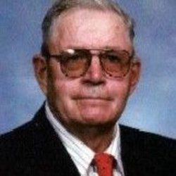
| Description | : | Ronald Dale Nissen the son of Ernest and Bonnie Maxine (Bates) Nissen was born April 29, 1937 in rural Graettinger, Iowa. He died on Tuesday, June 30, 2015 at the Good Samaritan Society in Estherville, Iowa at the age of 78. Ron served in the United States Marine Corps from 1954 until 1957. On August 2, 1958 he was united in marriage to Mary Hereim at the First Lutheran Church in Graettinger. The couple lived in the Graettinger area and Ronald worked as a farm hand, Graettinger Block & Tile and Pamline. He also worked many years at the... Read More |
frequently asked questions (FAQ):
-
Where is Ronald Dale “Smiley” Nissen's memorial?
Ronald Dale “Smiley” Nissen's memorial is located at: Valley View Cemetery, Walnut Township, Palo Alto County, USA.
-
When did Ronald Dale “Smiley” Nissen death?
Ronald Dale “Smiley” Nissen death on 30 Jun 2015 in Estherville, Emmet County, Iowa, USA
-
Where are the coordinates of the Ronald Dale “Smiley” Nissen's memorial?
Latitude: 43.2428000
Longitude: -94.7212000
Family Members:
Parent

Spouse
Siblings
Flowers:


Nearby Cemetories:
1. Valley View Cemetery
Walnut Township, Palo Alto County, USA
Coordinate: 43.2428000, -94.7212000
2. Saint Jacobs Cemetery
Graettinger, Palo Alto County, USA
Coordinate: 43.2546997, -94.7705994
3. Graettinger City Cemetery
Graettinger, Palo Alto County, USA
Coordinate: 43.2550011, -94.7722015
4. High Lake Jack Creek Cemetery
Wallingford, Emmet County, USA
Coordinate: 43.3006500, -94.7000620
5. Saint Paul Lutheran Cemetery
Walnut Township, Palo Alto County, USA
Coordinate: 43.1866740, -94.7872050
6. Wallingford Lutheran Cemetery
Wallingford, Emmet County, USA
Coordinate: 43.3128014, -94.7731018
7. Vernon Township Cemetery
Vernon Township, Palo Alto County, USA
Coordinate: 43.1840000, -94.6185000
8. Lost Island Lutheran Cemetery
Lost Island Township, Palo Alto County, USA
Coordinate: 43.1980000, -94.8375000
9. Center Township Cemetery
Emmet County, USA
Coordinate: 43.3608000, -94.6790000
10. Highland Cemetery
Highland Township, Palo Alto County, USA
Coordinate: 43.1497002, -94.8578033
11. Evergreen Cemetery
Emmetsburg, Palo Alto County, USA
Coordinate: 43.0940018, -94.6791992
12. Saint Johns Catholic Cemetery
Emmetsburg, Palo Alto County, USA
Coordinate: 43.0913200, -94.6790000
13. Swan Lake Township Cemetery
Maple Hill, Emmet County, USA
Coordinate: 43.3850746, -94.6381378
14. Saint Patricks Cemetery
Estherville, Emmet County, USA
Coordinate: 43.3843994, -94.8283005
15. Crown Hill Cemetery
Ruthven, Palo Alto County, USA
Coordinate: 43.1328011, -94.8878021
16. Calvary Cemetery
Ruthven, Palo Alto County, USA
Coordinate: 43.1314011, -94.8869019
17. Fairview Cemetery
Terril, Dickinson County, USA
Coordinate: 43.2977982, -94.9349976
18. North Saint John's Lutheran Cemetery
Independence Township, Palo Alto County, USA
Coordinate: 43.1696281, -94.5077438
19. East Side Cemetery
Estherville, Emmet County, USA
Coordinate: 43.4068985, -94.8264008
20. Oak Hill Cemetery
Estherville, Emmet County, USA
Coordinate: 43.3986015, -94.8518982
21. Saint John Lutheran Cemetery
Ringsted, Emmet County, USA
Coordinate: 43.3004080, -94.4812520
22. Memorial Cemetery
Ringsted, Emmet County, USA
Coordinate: 43.3009070, -94.4814670
23. Saint John's Lutheran Cemetery
Fairfield Township, Palo Alto County, USA
Coordinate: 43.1265000, -94.5017000
24. East Side Memorial Cemetery
Estherville, Emmet County, USA
Coordinate: 43.4267750, -94.8265600