
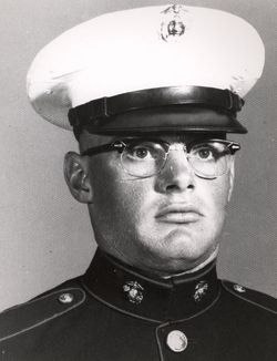
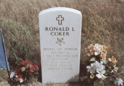
Ronald Leroy Coker Famous memorial
| Birth | : | 9 Aug 1947 Alliance, Box Butte County, Nebraska, USA |
| Death | : | 24 Mar 1969 |
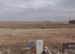
| Burial | : | Whitstable Cemetery, Whitstable, City of Canterbury, England |
| Coordinate | : | 51.3529870, 1.0338530 |
| Description | : | Vietnam War Medal of Honor Recipient. He received the award posthumously (presented to his family) from Vice President Spiro T. Agnew at the White House on April 20, 1970, for his actions as a private first class with the 2nd Platoon, Company M, 3rd Battalion, 3rd US Marines, on March 24, 1969, in Quang Tri Province, South Vietnam. He was drafted into the US Marine Corps in April 1968 and following his combat training, he joined a replacement company, Staging Battalion, at Camp Pendleton, California, for transfer to South Vietnam. He was assigned duty as a rifleman and was killed... Read More |
frequently asked questions (FAQ):
-
Where is Ronald Leroy Coker Famous memorial's memorial?
Ronald Leroy Coker Famous memorial's memorial is located at: Whitstable Cemetery, Whitstable, City of Canterbury, England.
-
When did Ronald Leroy Coker Famous memorial death?
Ronald Leroy Coker Famous memorial death on 24 Mar 1969 in
-
Where are the coordinates of the Ronald Leroy Coker Famous memorial's memorial?
Latitude: 51.3529870
Longitude: 1.0338530
Family Members:
Parent
Siblings
Flowers:


Nearby Cemetories:
1. All Saints Churchyard
Whitstable, City of Canterbury, England
Coordinate: 51.3558090, 1.0396670
2. St Alphege Churchyard
Whitstable, City of Canterbury, England
Coordinate: 51.3576330, 1.0251080
3. St. Alphege's Churchyard
Seasalter, City of Canterbury, England
Coordinate: 51.3432041, 1.0041740
4. St John the Baptist Churchyard
Swalecliffe, City of Canterbury, England
Coordinate: 51.3645500, 1.0667200
5. St Cosmus and St Damian Churchyard
Blean, City of Canterbury, England
Coordinate: 51.3052720, 1.0530480
6. Herne Bay Cemetery
Herne Bay, City of Canterbury, England
Coordinate: 51.3571810, 1.1304820
7. All Saints Churchyard
Graveney, Swale Borough, England
Coordinate: 51.3261450, 0.9447880
8. St Martins
Herne, City of Canterbury, England
Coordinate: 51.3500600, 1.1333200
9. St Martin's Churchyard
Herne, City of Canterbury, England
Coordinate: 51.3497060, 1.1334370
10. St Michael Churchyard
Hernhill, Swale Borough, England
Coordinate: 51.3077430, 0.9612050
11. Canterbury City Cemetery
Canterbury, City of Canterbury, England
Coordinate: 51.2843285, 1.0637640
12. St Nicholas Hospital Church
Harbledown, City of Canterbury, England
Coordinate: 51.2828200, 1.0536580
13. Christ Church Churchyard
Dunkirk, Swale Borough, England
Coordinate: 51.2916540, 0.9741890
14. St Michael and All Angels Church
Harbledown, City of Canterbury, England
Coordinate: 51.2824590, 1.0556800
15. Canterbury Jewish Cemetery
Canterbury, City of Canterbury, England
Coordinate: 51.2846135, 1.0706660
16. St. Dunstan Churchyard
Canterbury, City of Canterbury, England
Coordinate: 51.2836820, 1.0707800
17. St Bartholomew Churchyard
Goodnestone, Dover District, England
Coordinate: 51.3166220, 0.9322200
18. Sturry Cemetery
Sturry, City of Canterbury, England
Coordinate: 51.3058100, 1.1277700
19. St. John the Baptist Hospital Chapelyard
Canterbury, City of Canterbury, England
Coordinate: 51.2832713, 1.0837677
20. Holy Cross Church
Canterbury, City of Canterbury, England
Coordinate: 51.2811350, 1.0755710
21. St Nicholas Churchyard
Sturry, City of Canterbury, England
Coordinate: 51.2984830, 1.1201330
22. Westgate Gardens
Canterbury, City of Canterbury, England
Coordinate: 51.2805250, 1.0745040
23. St Gregory's Priory (defunct)
Canterbury, City of Canterbury, England
Coordinate: 51.2831127, 1.0855358
24. St Peter the Apostle Churchyard
Canterbury, City of Canterbury, England
Coordinate: 51.2807260, 1.0775370