

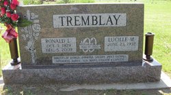
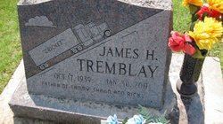
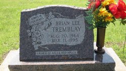
Ronald Louis “Cobb” Tremblay
| Birth | : | 3 Oct 1929 Saint Joseph, Cloud County, Kansas, USA |
| Death | : | 5 Dec 2009 Clifton, Washington County, Kansas, USA |
| Burial | : | Saint Joseph Cemetery, Saint Joseph, Cloud County, USA |
| Coordinate | : | 39.5074941, -97.4022328 |
| Plot | : | Site B/3 |
| Inscription | : | Married Aug. 17, 1950 Parents of Sharon, Barbara, Sandra, Janet, Michael, Katherine, Ronnie, Teri, Brian, Kaylene and Lynette |
| Description | : | NAME AND AGE: Ronald L. Cobb Tremblay, 80 FUNERAL: Services were December 8, 2009, at the St. John Catholic Church in Clyde, Kansas. BURIAL: St. Joe Cemetery, St. Joe, Kansas VISITATION: Turner Funeral Home, Clifton, Kansas was in charge of arrangements. MEMORIALS: Ronald Tremblay Memorial Fund to be designated later by the family in care of the funeral home. DATE/PLACE OF BIRTH: October 3, 1929, St. Joe, Kansas DATE/PLACE OF DEATH: December 5, 2009, Community Care Inc., Clifton, Kansas. BIOGRAPHY: Ronald was the son of Adelore and Eda Provost Tremblay. He grew up and attended school in St. Joe, Kansas. Mr. Tremblay farmed in the Clifton and... Read More |
frequently asked questions (FAQ):
-
Where is Ronald Louis “Cobb” Tremblay's memorial?
Ronald Louis “Cobb” Tremblay's memorial is located at: Saint Joseph Cemetery, Saint Joseph, Cloud County, USA.
-
When did Ronald Louis “Cobb” Tremblay death?
Ronald Louis “Cobb” Tremblay death on 5 Dec 2009 in Clifton, Washington County, Kansas, USA
-
Where are the coordinates of the Ronald Louis “Cobb” Tremblay's memorial?
Latitude: 39.5074941
Longitude: -97.4022328
Family Members:
Parent
Spouse

Siblings
Children
Flowers:


Nearby Cemetories:
1. Saint Joseph Cemetery
Saint Joseph, Cloud County, USA
Coordinate: 39.5074941, -97.4022328
2. Pleasant View Cemetery
Ames, Cloud County, USA
Coordinate: 39.5346985, -97.4431000
3. Cedar Grove Cemetery
Clyde, Cloud County, USA
Coordinate: 39.5494003, -97.4056015
4. Iwacura Cemetery
Morganville, Clay County, USA
Coordinate: 39.4550000, -97.3510000
5. French Presbyterian Church Cemetery
Cloud County, USA
Coordinate: 39.4395200, -97.4148290
6. Green Mound Cemetery
Rice, Cloud County, USA
Coordinate: 39.5248450, -97.5081630
7. Riverdale Cemetery
Clay County, USA
Coordinate: 39.5106010, -97.2930984
8. Mount Calvary Cemetery
Clyde, Cloud County, USA
Coordinate: 39.5917015, -97.4143982
9. Princeville Cemetery
Aurora, Cloud County, USA
Coordinate: 39.4672012, -97.5010986
10. Mount Hope Cemetery
Clyde, Cloud County, USA
Coordinate: 39.5969009, -97.4116974
11. Saint Peters Cemetery
Aurora, Cloud County, USA
Coordinate: 39.4763985, -97.5180969
12. Walnut Grove Cemetery
Cloud County, USA
Coordinate: 39.5699997, -97.4993973
13. Nelson Cemetery
Rice, Cloud County, USA
Coordinate: 39.5257988, -97.5410995
14. Bloom Cemetery
Morganville, Clay County, USA
Coordinate: 39.4519005, -97.2778015
15. Lincoln Cemetery
Clay Center, Clay County, USA
Coordinate: 39.4230995, -97.2930984
16. Sulphur Springs Cemetery
Aurora, Cloud County, USA
Coordinate: 39.4086610, -97.4986840
17. Rice Cemetery
Rice, Cloud County, USA
Coordinate: 39.5614014, -97.5552979
18. Sherman Cemetery
Morganville, Clay County, USA
Coordinate: 39.5316300, -97.2243700
19. Smith Grave
Miltonvale, Cloud County, USA
Coordinate: 39.3645300, -97.4308700
20. Hollis Cemetery
Cloud County, USA
Coordinate: 39.6383018, -97.5361023
21. Norwegian Lutheran Cemetery
Clay Center, Clay County, USA
Coordinate: 39.5027900, -97.1828200
22. Agenda Cemetery
Agenda, Republic County, USA
Coordinate: 39.6761017, -97.4336014
23. Morganville City Cemetery
Morganville, Clay County, USA
Coordinate: 39.4733009, -97.1819000
24. Miltonvale Cemetery
Miltonvale, Cloud County, USA
Coordinate: 39.3358002, -97.4447021