

Ronald William Tilbury
| Birth | : | 15 Apr 1936 Backus, Cass County, Minnesota, USA |
| Death | : | 24 Apr 2012 Chelan, Chelan County, Washington, USA |
| Burial | : | Chelan Fraternal Cemetery, Chelan, Chelan County, USA |
| Coordinate | : | 47.8502998, -120.0081024 |
| Plot | : | North Fraternal Row41 BLK44 LS4 |
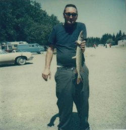
| Description | : | m: Vonsielle Gausiline (Waterbury) Acord 18 Nov 1958 (later m: Woodrow Wilson Juette and Marvin Fenner) children: Randy Lee and Ronald Dean (later adopted by stepfather Woodrow Juette) Ronald W. Tilbury, 76, a 50 year resident of Chelan, died Tuesday, April 24, 2012 at his home following a brief illness. He was born April 15, 1936, at Backus, Minnesota, the son of James and Ethel (Sawyer) Tilbury. He resided at Backus for 12 years before moving with his family to Bozeman, Montana. There he was employed in logging. In 1951, he moved to Twisp where he was... Read More |
frequently asked questions (FAQ):
-
Where is Ronald William Tilbury's memorial?
Ronald William Tilbury's memorial is located at: Chelan Fraternal Cemetery, Chelan, Chelan County, USA.
-
When did Ronald William Tilbury death?
Ronald William Tilbury death on 24 Apr 2012 in Chelan, Chelan County, Washington, USA
-
Where are the coordinates of the Ronald William Tilbury's memorial?
Latitude: 47.8502998
Longitude: -120.0081024
Family Members:

Flowers:


Nearby Cemetories:
1. Chelan Fraternal Cemetery
Chelan, Chelan County, USA
Coordinate: 47.8502998, -120.0081024
2. Mount Olivet Cemetery
Chelan, Chelan County, USA
Coordinate: 47.8451000, -119.9946000
3. Saint Andrews Episcopal Church
Chelan, Chelan County, USA
Coordinate: 47.8397460, -120.0183780
4. Riverview Cemetery
Chelan, Chelan County, USA
Coordinate: 47.8335991, -119.9944000
5. Manson Indian Cemetery
Manson, Chelan County, USA
Coordinate: 47.8800000, -120.1300000
6. Ballard Family Cemetery
Stayman, Chelan County, USA
Coordinate: 47.7811100, -120.1133300
7. Fletcher Cemetery
Douglas County, USA
Coordinate: 47.7430992, -119.9403000
8. Brays Landing Cemetery
Douglas County, USA
Coordinate: 47.7364120, -120.1704660
9. Kummer Cemetery
Waterville, Douglas County, USA
Coordinate: 47.6559000, -120.0332000
10. Packwood Memorial Cemetery
Dyer, Douglas County, USA
Coordinate: 48.0118305, -119.8178880
11. Dick Family Cemetery
Okanogan County, USA
Coordinate: 48.0502700, -119.9241700
12. Miller Family Cemetery
Okanogan County, USA
Coordinate: 48.0530300, -119.9288000
13. Pateros Cemetery
Pateros, Okanogan County, USA
Coordinate: 48.0516600, -119.9097300
14. Waterville Cemetery
Waterville, Douglas County, USA
Coordinate: 47.6418500, -120.0685940
15. Gate of Heaven Catholic Cemetery
Waterville, Douglas County, USA
Coordinate: 47.6382100, -120.0671690
16. Douglas Lutheran Cemetery
Douglas County, USA
Coordinate: 47.6189003, -119.9614029
17. Badger Mountain View Cemetery
Douglas County, USA
Coordinate: 47.6088000, -120.0476000
18. Mansfield Cemetery
Mansfield, Douglas County, USA
Coordinate: 47.8088880, -119.6508330
19. Orondo Community Cemetery
Orondo, Douglas County, USA
Coordinate: 47.6486015, -120.2136002
20. Buckingham Cemetery
Douglas County, USA
Coordinate: 47.8669014, -119.6286011
21. Happy Home Cemetery
Farmer, Douglas County, USA
Coordinate: 47.6268997, -119.8125000
22. Methow Cemetery
Methow, Okanogan County, USA
Coordinate: 48.1102982, -120.0124969
23. Entiat Cemetery
Entiat, Chelan County, USA
Coordinate: 47.6755981, -120.3043976
24. Bridgeport Cemetery
Bridgeport, Douglas County, USA
Coordinate: 48.0050000, -119.6738800