
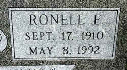

Ronell E. Derusseau
| Birth | : | 17 Sep 1910 Clyde, Cloud County, Kansas, USA |
| Death | : | 8 May 1992 Concordia, Cloud County, Kansas, USA |
| Burial | : | Mount Hope Cemetery, Clyde, Cloud County, USA |
| Coordinate | : | 39.5969009, -97.4116974 |
| Plot | : | Site 12-19 |
| Inscription | : | Wedding ring symbol with: MARRIED MAR 28 1941 BELOVED PARENTS OF RONALD W. |
| Description | : | Salina Journal – May 9, 1992 Ronell E. Derusseau CONCORDIA — Ronell E. Derusseau, 81, Concordia, died Friday, May 8, 1992, at St. Joseph Hospital, Concordia. Mr. Derusseau was born Sept. 17, 1910, at Clyde and had lived in Concordia for many years. He was an Army veteran of World War II. He worked with the Boogaart Stores for 35 years, retiring as general manager of the meat products division. He was a member of the First United Methodist Church, the Elks Lodge, the Moose Lodge, the Veterans of Foreign Wars and the Country Club, all of Concordia. Survivors include his wife, Marjorie... Read More |
frequently asked questions (FAQ):
-
Where is Ronell E. Derusseau's memorial?
Ronell E. Derusseau's memorial is located at: Mount Hope Cemetery, Clyde, Cloud County, USA.
-
When did Ronell E. Derusseau death?
Ronell E. Derusseau death on 8 May 1992 in Concordia, Cloud County, Kansas, USA
-
Where are the coordinates of the Ronell E. Derusseau's memorial?
Latitude: 39.5969009
Longitude: -97.4116974
Family Members:
Parent

Spouse
Siblings
Flowers:


Nearby Cemetories:
1. Mount Calvary Cemetery
Clyde, Cloud County, USA
Coordinate: 39.5917015, -97.4143982
2. Cedar Grove Cemetery
Clyde, Cloud County, USA
Coordinate: 39.5494003, -97.4056015
3. Pleasant View Cemetery
Ames, Cloud County, USA
Coordinate: 39.5346985, -97.4431000
4. Walnut Grove Cemetery
Cloud County, USA
Coordinate: 39.5699997, -97.4993973
5. Agenda Cemetery
Agenda, Republic County, USA
Coordinate: 39.6761017, -97.4336014
6. Saint Joseph Cemetery
Saint Joseph, Cloud County, USA
Coordinate: 39.5074941, -97.4022328
7. Beck Family Cemetery
Agenda, Republic County, USA
Coordinate: 39.6818000, -97.4863000
8. Green Mound Cemetery
Rice, Cloud County, USA
Coordinate: 39.5248450, -97.5081630
9. Hollis Cemetery
Cloud County, USA
Coordinate: 39.6383018, -97.5361023
10. Rice Cemetery
Rice, Cloud County, USA
Coordinate: 39.5614014, -97.5552979
11. Nelson Cemetery
Rice, Cloud County, USA
Coordinate: 39.5257988, -97.5410995
12. Riverdale Cemetery
Clay County, USA
Coordinate: 39.5106010, -97.2930984
13. Willoughby Cemetery
Agenda, Republic County, USA
Coordinate: 39.7402992, -97.4244003
14. Union Cemetery
Wayne, Republic County, USA
Coordinate: 39.6977997, -97.5457993
15. Saint Peters Cemetery
Aurora, Cloud County, USA
Coordinate: 39.4763985, -97.5180969
16. Princeville Cemetery
Aurora, Cloud County, USA
Coordinate: 39.4672012, -97.5010986
17. Iwacura Cemetery
Morganville, Clay County, USA
Coordinate: 39.4550000, -97.3510000
18. Gotland Cemetery
Sibley Township, Cloud County, USA
Coordinate: 39.6091995, -97.6125031
19. French Presbyterian Church Cemetery
Cloud County, USA
Coordinate: 39.4395200, -97.4148290
20. Sherman Cemetery
Morganville, Clay County, USA
Coordinate: 39.5316300, -97.2243700
21. Zion Cemetery
Agenda, Republic County, USA
Coordinate: 39.6749992, -97.5939026
22. Rose Hill Cemetery
Wayne, Republic County, USA
Coordinate: 39.7111015, -97.5661011
23. Minersville Cemetery
Talmo, Republic County, USA
Coordinate: 39.6568330, -97.6229250
24. Bloom Cemetery
Morganville, Clay County, USA
Coordinate: 39.4519005, -97.2778015