
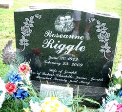
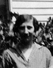
Roseanne Clark Riggle
| Birth | : | 20 Jun 1922 Putnam County, Indiana, USA |
| Death | : | 23 Feb 2009 Roachdale, Putnam County, Indiana, USA |
| Burial | : | St Andrew Churchyard, South Stoke, South Oxfordshire District, England |
| Coordinate | : | 51.5479065, -1.1377167 |
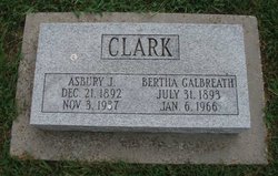
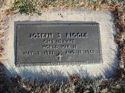
| Description | : | Roseanne Riggle, 86, of Roachdale died at her residence on Monday, Feb. 23, 2009. She was born in Putnam County on June 20, 1922 to Asbury Clark and Bertha Galbreath Clark. She graduated from Roachdale High School in 1940. She married Joseph Spencer Riggle on Jan. 11, 1947 in Roachdale, and he preceded her in death on August 18, 1981. Mrs. Riggle was a member of the Roachdale Christian Church and the V.F.W. Auxiliary Post 3284. She is survived by two sons, Robert Riggle and wife Geraldine of Fairview Heights, Ill. and Herschel Riggle and wife Barb of Roachdale; three... Read More |
frequently asked questions (FAQ):
-
Where is Roseanne Clark Riggle's memorial?
Roseanne Clark Riggle's memorial is located at: St Andrew Churchyard, South Stoke, South Oxfordshire District, England.
-
When did Roseanne Clark Riggle death?
Roseanne Clark Riggle death on 23 Feb 2009 in Roachdale, Putnam County, Indiana, USA
-
Where are the coordinates of the Roseanne Clark Riggle's memorial?
Latitude: 51.5479065
Longitude: -1.1377167
Family Members:
Parent
Spouse
Siblings
Children


Nearby Cemetories:
1. St Andrew Churchyard
South Stoke, South Oxfordshire District, England
Coordinate: 51.5479065, -1.1377167
2. St John the Baptist
Moulsford, South Oxfordshire District, England
Coordinate: 51.5531050, -1.1482640
3. St. Mary Churchyard
Streatley, West Berkshire Unitary Authority, England
Coordinate: 51.5240170, -1.1449500
4. St. Mary's Churchyard
North Stoke, South Oxfordshire District, England
Coordinate: 51.5714910, -1.1228080
5. St. Thomas of Canterbury Churchyard
Goring, South Oxfordshire District, England
Coordinate: 51.5221440, -1.1399970
6. Whitehill Burial Ground
Goring, South Oxfordshire District, England
Coordinate: 51.5214730, -1.1180180
7. St. Mary's Churchyard
Cholsey, South Oxfordshire District, England
Coordinate: 51.5788078, -1.1589500
8. St. Mary the Virgin Cemetery
Ipsden, South Oxfordshire District, England
Coordinate: 51.5674164, -1.0866686
9. St. John the Baptist Church (Defunct)
Mongwell, South Oxfordshire District, England
Coordinate: 51.5860980, -1.1233580
10. St. Leonard's Churchyard
Woodcote, South Oxfordshire District, England
Coordinate: 51.5348117, -1.0731299
11. St Michael's Cemetery
Aston Tirrold, South Oxfordshire District, England
Coordinate: 51.5730994, -1.1967145
12. All Saints Churchyard
Aston Upthorpe, South Oxfordshire District, England
Coordinate: 51.5715900, -1.2037500
13. St. Leonard's Churchyard
Wallingford, South Oxfordshire District, England
Coordinate: 51.5972711, -1.1230712
14. St. John the Baptist South Moreton
South Moreton, South Oxfordshire District, England
Coordinate: 51.5881630, -1.1895850
15. St. Mary-le-More Churchyard
Wallingford, South Oxfordshire District, England
Coordinate: 51.5993878, -1.1249488
16. St Mary Magdalene Churchyard
Crowmarsh Gifford, South Oxfordshire District, England
Coordinate: 51.5992169, -1.1139564
17. Saint Peter's Churchyard
Wallingford, South Oxfordshire District, England
Coordinate: 51.6005819, -1.1215970
18. South Moreton Strict Baptist Chapel
South Moreton, South Oxfordshire District, England
Coordinate: 51.5900300, -1.1924310
19. All Hallows Graveyard
Wallingford, South Oxfordshire District, England
Coordinate: 51.6020520, -1.1242267
20. St. John the Baptist Churchyard
Whitchurch Hill, South Oxfordshire District, England
Coordinate: 51.5050469, -1.0824315
21. St. Mary the Virgin Churchyard
Aldworth, West Berkshire Unitary Authority, England
Coordinate: 51.5106800, -1.2030150
22. Checkendon Churchyard
Checkendon, South Oxfordshire District, England
Coordinate: 51.5424461, -1.0449720
23. Wallingford Cemetery
Wallingford, South Oxfordshire District, England
Coordinate: 51.6058200, -1.1232000
24. All Saints Churchyard
North Moreton, South Oxfordshire District, England
Coordinate: 51.6021922, -1.1898247