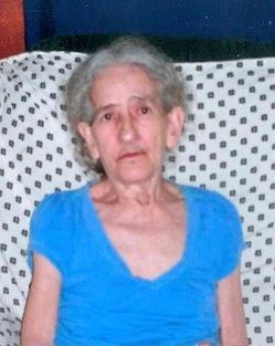
| Birth | : | 6 May 1944 Wise County, Virginia, USA |
| Death | : | 19 Jan 2011 Washington, District of Columbia, District of Columbia, USA |
| Burial | : | Saint George's Poplar Hill Episcopal Cemetery, Valley Lee, St. Mary's County, USA |
| Coordinate | : | 38.1954689, -76.5212631 |
| Description | : | Carter, Rosetta Mary Birth: Saturday, May 06, 1944 in Wise County, Virginia Residence: Valley Lee, Maryland Death: Wednesday, January 19, 2011 at the age of 66 Laid to Rest: Tuesday, January 25, 2011 in the St. George’s Episcopal Cemetery, Valley Lee, Maryland Rosetta Mary "Rosie" Carter, 66, of Valley Lee, MD, died January 19, 2011 at George Washington University Hospital, Washington, DC. Born May 6, 1944 in Wise County, VA, she was the daughter of the late Venus and Leonard Freeman. Mrs. Carter was a devoted wife, mother, grandmother and great grandmother, who enjoyed life with her... Read More |
frequently asked questions (FAQ):
-
Where is Rosetta Mary “ROSIE” Freeman Carter's memorial?
Rosetta Mary “ROSIE” Freeman Carter's memorial is located at: Saint George's Poplar Hill Episcopal Cemetery, Valley Lee, St. Mary's County, USA.
-
When did Rosetta Mary “ROSIE” Freeman Carter death?
Rosetta Mary “ROSIE” Freeman Carter death on 19 Jan 2011 in Washington, District of Columbia, District of Columbia, USA
-
Where are the coordinates of the Rosetta Mary “ROSIE” Freeman Carter's memorial?
Latitude: 38.1954689
Longitude: -76.5212631
Family Members:
Parent
Spouse
Siblings
Flowers:
Nearby Cemetories:
1. Saint George's Poplar Hill Episcopal Cemetery
Valley Lee, St. Mary's County, USA
Coordinate: 38.1954689, -76.5212631
2. Saint George's Roman Catholic Cemetery
Valley Lee, St. Mary's County, USA
Coordinate: 38.1940842, -76.5042114
3. Saint Marks UAME Cemetery
Valley Lee, St. Mary's County, USA
Coordinate: 38.1989200, -76.4957000
4. Bethesda United Methodist Cemetery
Valley Lee, St. Mary's County, USA
Coordinate: 38.1981812, -76.4946976
5. Seafarers Haven Cemetery
Drayden, St. Mary's County, USA
Coordinate: 38.1589928, -76.5002670
6. Saint Marys Youth Memorial Park
Great Mills, St. Mary's County, USA
Coordinate: 38.2367477, -76.4956131
7. Holy Face Cemetery
Great Mills, St. Mary's County, USA
Coordinate: 38.2406006, -76.5096970
8. Glen Mary Farms Cemetery (Defunct)
Park Hall, St. Mary's County, USA
Coordinate: 38.2171740, -76.4589480
9. Trinity Church Cemetery
Saint Marys City, St. Mary's County, USA
Coordinate: 38.1874084, -76.4350967
10. Saint Marys College of Maryland Burial Ground
Saint Marys City, St. Mary's County, USA
Coordinate: 38.1866074, -76.4310684
11. Father Andrew White Monument
Saint Marys City, St. Mary's County, USA
Coordinate: 38.1988700, -76.4281500
12. Chapel Field
Saint Marys City, St. Mary's County, USA
Coordinate: 38.1831370, -76.4281080
13. Great Brick Chapel
Saint Marys City, St. Mary's County, USA
Coordinate: 38.1832450, -76.4278400
14. Slovack Cemetery
Saint Marys City, St. Mary's County, USA
Coordinate: 38.1873817, -76.4246368
15. Park Hall True Holiness Church Cemetery
Park Hall, St. Mary's County, USA
Coordinate: 38.2177315, -76.4247665
16. Evergreen Memorial Gardens
Great Mills, St. Mary's County, USA
Coordinate: 38.2724686, -76.4940033
17. First Saints Community Church Cemetery
Saint George Island, St. Mary's County, USA
Coordinate: 38.1207008, -76.4813004
18. Saint Luke UAME Cemetery
Saint George Island, St. Mary's County, USA
Coordinate: 38.1174300, -76.4815800
19. Saint Francis Xavier Chapel Cemetery
Saint George Island, St. Mary's County, USA
Coordinate: 38.1170600, -76.4815220
20. Old Community Cemetery
Saint George Island, St. Mary's County, USA
Coordinate: 38.1169140, -76.4814040
21. First Missionary Baptist Church Cemetery
Lexington Park, St. Mary's County, USA
Coordinate: 38.2455606, -76.4298946
22. Ebenezer United Methodist Cemetery
Great Mills, St. Mary's County, USA
Coordinate: 38.2818604, -76.4950638
23. Saint Ignatius Church Cemetery
Saint Inigoes, St. Mary's County, USA
Coordinate: 38.1501503, -76.4231491
24. Zion United Methodist Church Cemetery
Hermanville, St. Mary's County, USA
Coordinate: 38.2462700, -76.4265000


