
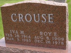
Roy Edward Crouse
| Birth | : | 8 Aug 1909 |
| Death | : | 26 Dec 1978 |
| Burial | : | Calvary Cemetery, La Junta, Otero County, USA |
| Coordinate | : | 37.9832000, -103.5622000 |
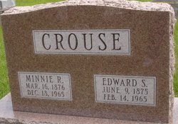
| Description | : | Roy E. Crouse was born near Panther, the fifth of eight children, to Edward and Minnie Messamer Crouse on August 8, 1909. He died at his retirement home in Bella Vista, Arkansas on December 26, 1978. He was reared in and spent most of his working years in the Panther Community. He was graduated from Adel High School in 1927. As a young man he worked for farmers in the Panther and Dallas Center communities. He was married to Iva Mae Walker June 23, 1940. They took up residence at Modesto, California where Roy worked in the construction industry with... Read More |
frequently asked questions (FAQ):
-
Where is Roy Edward Crouse's memorial?
Roy Edward Crouse's memorial is located at: Calvary Cemetery, La Junta, Otero County, USA.
-
When did Roy Edward Crouse death?
Roy Edward Crouse death on 26 Dec 1978 in
-
Where are the coordinates of the Roy Edward Crouse's memorial?
Latitude: 37.9832000
Longitude: -103.5622000
Family Members:
Parent
Spouse

Siblings
Flowers:


Nearby Cemetories:
1. Calvary Cemetery
La Junta, Otero County, USA
Coordinate: 37.9832000, -103.5622000
2. Fairview Cemetery
La Junta, Otero County, USA
Coordinate: 37.9873000, -103.5607000
3. Saint Andrews Episcopal Church Columbarium
La Junta, Otero County, USA
Coordinate: 37.9809000, -103.5455000
4. Ormega Cemetery
La Junta, Otero County, USA
Coordinate: 37.9684000, -103.5770000
5. Saint Paul’s Lutheran Cemetery
Otero County, USA
Coordinate: 38.0342000, -103.4542000
6. Holbrook Cemetery
Otero County, USA
Coordinate: 38.0842018, -103.5432968
7. Bents Old Fort Cemetery
La Junta, Otero County, USA
Coordinate: 38.0416000, -103.4297000
8. Hillcrest Cemetery
Rocky Ford, Otero County, USA
Coordinate: 38.0388985, -103.7071991
9. Valley View Cemetery
Rocky Ford, Otero County, USA
Coordinate: 38.0388985, -103.7093964
10. East Holbrook Mennonite Cemetery
Cheraw, Otero County, USA
Coordinate: 38.1101837, -103.4729767
11. Higbee Cemetery
Higbee, Otero County, USA
Coordinate: 37.7630997, -103.4555969
12. Timpas Cemetery
Timpas, Otero County, USA
Coordinate: 37.8081000, -103.7681000
13. Martinez Cemetery
Otero County, USA
Coordinate: 37.7303009, -103.5002975
14. Lakeview Cemetery
Sugar City, Crowley County, USA
Coordinate: 38.2332993, -103.6725006
15. Manzanola Mountainview Cemetery
Manzanola, Otero County, USA
Coordinate: 38.0900002, -103.8764038
16. Las Animas Cemetery
Las Animas, Bent County, USA
Coordinate: 38.0424995, -103.2174988
17. Boggsville National Historic Site Grounds
Boggsville, Bent County, USA
Coordinate: 38.0425130, -103.2102730
18. Valley View Cemetery
Ordway, Crowley County, USA
Coordinate: 38.2546997, -103.7489014
19. Olney Springs Cemetery
Olney Springs, Crowley County, USA
Coordinate: 38.1472282, -103.9310684
20. Pruett Cemetery
Bent County, USA
Coordinate: 37.7172012, -103.2897034
21. Dolores Mission Cemetery
Kim, Las Animas County, USA
Coordinate: 37.6365200, -103.5854900
22. Barnard Burial Site
Elder, Otero County, USA
Coordinate: 38.1235554, -103.9665095
23. Fort Lyon National Cemetery
Fort Lyon, Bent County, USA
Coordinate: 38.0847015, -103.1288986
24. Arlington Cemetery
Arlington, Kiowa County, USA
Coordinate: 38.3232994, -103.3597031