
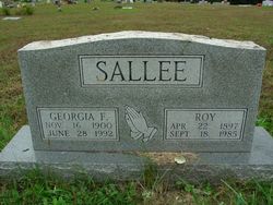
Roy Sallee
| Birth | : | 22 Apr 1897 USA |
| Death | : | 18 Sep 1985 Saint Louis, St. Louis County, Missouri, USA |
| Burial | : | Agecroft Cemetery and Crematorium, Salford, Metropolitan Borough of Salford, England |
| Coordinate | : | 53.5100250, -2.2940500 |
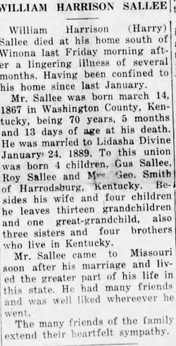
| Description | : | ROY SALLEE Roy Sallee was born April 22, 1897, the son of William Harrison and Lydoshia Devine Sallee and passed away at St. Luke Hospital in St. Louis, Mo. on September 18, 1985 at the age of 88 years, 4 months and 18 days. He was united in marriage to Georgia Francis Snelson on February 7, 1920 at Winona, Mo. and to this union five children were born. Roy attended Winona school in his youth. As a young man he worked in the logging industries here in Shannon County. Roy served in the Army during World War... Read More |
frequently asked questions (FAQ):
-
Where is Roy Sallee's memorial?
Roy Sallee's memorial is located at: Agecroft Cemetery and Crematorium, Salford, Metropolitan Borough of Salford, England.
-
When did Roy Sallee death?
Roy Sallee death on 18 Sep 1985 in Saint Louis, St. Louis County, Missouri, USA
-
Where are the coordinates of the Roy Sallee's memorial?
Latitude: 53.5100250
Longitude: -2.2940500
Family Members:
Parent
Spouse

Siblings
Children
Flowers:


Nearby Cemetories:
1. Agecroft Cemetery and Crematorium
Salford, Metropolitan Borough of Salford, England
Coordinate: 53.5100250, -2.2940500
2. Agecroft Jewish Cemetery
Pendlebury, Metropolitan Borough of Salford, England
Coordinate: 53.5110302, -2.2955830
3. Rainsough Jewish Cemetery
Prestwich, Metropolitan Borough of Bury, England
Coordinate: 53.5185530, -2.2906950
4. St John The Evangelist Churchyard
Pendlebury, Metropolitan Borough of Salford, England
Coordinate: 53.5036200, -2.3088500
5. St Paul's Churchyard
Salford, Metropolitan Borough of Salford, England
Coordinate: 53.5148800, -2.2725500
6. Saint Augustine's Churchyard
Pendlebury, Metropolitan Borough of Salford, England
Coordinate: 53.5107070, -2.3223960
7. St. Thomas' Churchyard
Salford, Metropolitan Borough of Salford, England
Coordinate: 53.4921430, -2.2856130
8. St. Mary the Virgin Churchyard
Prestwich, Metropolitan Borough of Bury, England
Coordinate: 53.5294033, -2.2864891
9. Great Synagogue Cemetery
Prestwich, Metropolitan Borough of Bury, England
Coordinate: 53.5315510, -2.2845730
10. St. Paul's Wesleyan Methodist Churchyard
Swinton, Metropolitan Borough of Salford, England
Coordinate: 53.5133900, -2.3397500
11. St. Peter's Churchyard
Swinton, Metropolitan Borough of Salford, England
Coordinate: 53.5119130, -2.3413860
12. St. Marks' Churchyard
Cheetham Hill, Metropolitan Borough of Manchester, England
Coordinate: 53.5113780, -2.2462660
13. Wesleyan Methodist Cemetery
Crumpsall, Metropolitan Borough of Manchester, England
Coordinate: 53.5142870, -2.2447610
14. Weaste Cemetery
Weaste, Metropolitan Borough of Salford, England
Coordinate: 53.4795227, -2.3017540
15. Swinton Cemetery
Swinton, Metropolitan Borough of Salford, England
Coordinate: 53.5183372, -2.3457739
16. St Anne Churchyard
Clifton, Metropolitan Borough of Salford, England
Coordinate: 53.5277070, -2.3391650
17. Strangeways Prison Cemetery (Defunct)
Manchester, Metropolitan Borough of Manchester, England
Coordinate: 53.4925000, -2.2463890
18. Irwell Street Wesleyan Chapel Cemetery
Salford, Metropolitan Borough of Salford, England
Coordinate: 53.4829750, -2.2587540
19. Manchester Reform Jewish Old Cemetery
Whitefield, Metropolitan Borough of Bury, England
Coordinate: 53.5442728, -2.2918894
20. New Jerusalem Temple Cemetery
Salford, Metropolitan Borough of Salford, England
Coordinate: 53.4827720, -2.2571250
21. St Mary the Virgin Churchyard
Eccles, Metropolitan Borough of Salford, England
Coordinate: 53.4843810, -2.3346810
22. St Luke's Churchyard
Cheetham Hill, Metropolitan Borough of Manchester, England
Coordinate: 53.5041660, -2.2354680
23. Christ Church
Salford, Metropolitan Borough of Salford, England
Coordinate: 53.4864284, -2.2497653
24. St Chad's Churchyard
Cheetham Hill, Metropolitan Borough of Manchester, England
Coordinate: 53.4922100, -2.2400500