Roy Sherman “'Roy'” White
| Birth | : | 26 Aug 1934 Walsenburg, Huerfano County, Colorado, USA |
| Death | : | 14 Mar 2000 Omaha, Douglas County, Nebraska, USA |
| Burial | : | Whenua Tapu Cemetery, Porirua, Porirua City, New Zealand |
| Coordinate | : | -41.0550200, 174.8757150 |
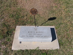
| Inscription | : | SP 5 US ARMY KOREA |
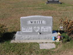
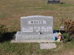
| Description | : | ROY S. WHITE was born August 26, 1934 near Walsenburg, Colorado. He was a long-time resident of Lebanon, Kansas. He died March 14, 2000, and is buried at St. Elizabeth's Catholic Church Cemetery, just south of Esbon, Jewell County, Kansas...visible on south side of U.S. Highway 36. Roy was a devoted husband to his dear wife Theresa (Terry) White and he was immensely proud of his daughters Donna, Denise, Delores, Joanne and his son (also named 'Roy') ---as well as his grandchildren, and the growing numbers of his great-grandchildren. Roy White was a hard... Read More |
frequently asked questions (FAQ):
-
Where is Roy Sherman “'Roy'” White's memorial?
Roy Sherman “'Roy'” White's memorial is located at: Whenua Tapu Cemetery, Porirua, Porirua City, New Zealand.
-
When did Roy Sherman “'Roy'” White death?
Roy Sherman “'Roy'” White death on 14 Mar 2000 in Omaha, Douglas County, Nebraska, USA
-
Where are the coordinates of the Roy Sherman “'Roy'” White's memorial?
Latitude: -41.0550200
Longitude: 174.8757150
Family Members:
Parent
Siblings
Flowers:
Nearby Cemetories:
1. Whenua Tapu Cemetery
Porirua, Porirua City, New Zealand
Coordinate: -41.0550200, 174.8757150
2. Hongoeka Urupā
Plimmerton, Porirua City, New Zealand
Coordinate: -41.0651560, 174.8525070
3. Plimmerton Urupā
Plimmerton, Porirua City, New Zealand
Coordinate: -41.0822790, 174.8641890
4. Pukerua Bay Urupā
Pukerua Bay, Porirua City, New Zealand
Coordinate: -41.0300425, 174.8969530
5. Battle Hill Burial Ground
Wellington, Wellington City, New Zealand
Coordinate: -41.0578590, 174.9352810
6. Pauatahanui Burial Ground
Pauatahanui, Porirua City, New Zealand
Coordinate: -41.1068190, 174.9173310
7. Saint Albans Burial Ground
Pauatahanui, Porirua City, New Zealand
Coordinate: -41.1067240, 174.9179340
8. Bradey Grave
Whitby, Porirua City, New Zealand
Coordinate: -41.1173161, 174.9056161
9. St Josephs Catholic Cemetery
Pauatahanui, Porirua City, New Zealand
Coordinate: -41.1135060, 174.9196220
10. Mataiwhetu St Urupā
Takapuwahia, Porirua City, New Zealand
Coordinate: -41.1208070, 174.8364500
11. Takapu Urupā
Takapuwahia, Porirua City, New Zealand
Coordinate: -41.1203960, 174.8330360
12. Ngati Toa Street Urupā
Takapuwahia, Porirua City, New Zealand
Coordinate: -41.1264070, 174.8344310
13. Porirua Cemetery
Porirua, Porirua City, New Zealand
Coordinate: -41.1453640, 174.8420300
14. Mira Family Urupā
Paraparaumu, Kapiti Coast District, New Zealand
Coordinate: -40.9753380, 174.9643460
15. Tawa Flat Cemetery
Tawa, Wellington City, New Zealand
Coordinate: -41.1580600, 174.8281800
16. Grasslees Reserve
Tawa, Wellington City, New Zealand
Coordinate: -41.1647415, 174.8284302
17. MacKay Family Cemetery
Kapiti Coast District, New Zealand
Coordinate: -40.9726800, 174.9833330
18. Christ Church Anglican Cemetery
Taita, Lower Hutt City, New Zealand
Coordinate: -41.1820960, 174.9600920
19. St. John's Anglican Churchyard Cemetery
Trentham, Upper Hutt City, New Zealand
Coordinate: -41.1303100, 175.0443500
20. Taita Old Cemetery
Naenae, Lower Hutt City, New Zealand
Coordinate: -41.1945700, 174.9564000
21. Boulcott Farm Cemetery
Lower Hutt, Lower Hutt City, New Zealand
Coordinate: -41.2030590, 174.9272750
22. Knox Presbyterian Church Cemetery
Lower Hutt, Lower Hutt City, New Zealand
Coordinate: -41.1965430, 174.9579920
23. Taita Lawn Cemetery
Naenae, Lower Hutt City, New Zealand
Coordinate: -41.1968900, 174.9634900
24. Bridge Street Cemetery
Lower Hutt, Lower Hutt City, New Zealand
Coordinate: -41.2117740, 174.8969660


