
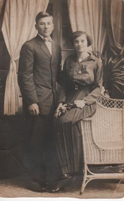
| Birth | : | 19 Nov 1903 Holt County, Nebraska, USA |
| Death | : | 2 May 1970 Fremont, Dodge County, Nebraska, USA |
| Burial | : | Riverview Cemetery, Saint Joseph, Berrien County, USA |
| Coordinate | : | 42.0657997, -86.4657974 |
| Description | : | Fremont Tribune (Fremont, Nebraska) 04 May 1970, Mon Page 5 Rudy J. Dostal Rites Scheduled Services for Rudy J. Dostal, 66, will be Tuesday at 10 a.m. at St. Patrick's Catholic Church with Rev. Paul Peter officiating. Mr. Dostal was born Nov. 19, 1903, in Holt County. He moved to Fremont 40 years ago from Dodge. He died Saturday morning in his home. Survivors include his widow, Blanche; two sons, Richard and LaVerne Rudy; one daughter, Mrs. Owen (Betty) Anthony, all of Independence, Mo.; three brothers, Emil, Dodge, Leon and Joe, both of... Read More |
frequently asked questions (FAQ):
-
Where is Rudolph Jack “Rudy” Dostal's memorial?
Rudolph Jack “Rudy” Dostal's memorial is located at: Riverview Cemetery, Saint Joseph, Berrien County, USA.
-
When did Rudolph Jack “Rudy” Dostal death?
Rudolph Jack “Rudy” Dostal death on 2 May 1970 in Fremont, Dodge County, Nebraska, USA
-
Where are the coordinates of the Rudolph Jack “Rudy” Dostal's memorial?
Latitude: 42.0657997
Longitude: -86.4657974
Family Members:
Parent

Spouse
Siblings
Children
Flowers:


Nearby Cemetories:
1. Riverview Cemetery
Saint Joseph, Berrien County, USA
Coordinate: 42.0657997, -86.4657974
2. Saint Joseph First UMC Memorial Garden
Saint Joseph, Berrien County, USA
Coordinate: 42.0810930, -86.4909620
3. Highland Cemetery
Saint Joseph, Berrien County, USA
Coordinate: 42.0650980, -86.4987150
4. First Congregational Church UCC Memorial Garden
Saint Joseph, Berrien County, USA
Coordinate: 42.0949790, -86.4842940
5. Hickory Bluff Cemetery
Stevensville, Berrien County, USA
Coordinate: 42.0398670, -86.4952000
6. Spring Run Cemetery
Scottdale, Berrien County, USA
Coordinate: 42.0407600, -86.4348526
7. Saint Joseph City Cemetery
Saint Joseph, Berrien County, USA
Coordinate: 42.0960090, -86.4905980
8. Jerome Cemetery
Saint Joseph, Berrien County, USA
Coordinate: 42.0302699, -86.4758279
9. Resurrection Cemetery
Saint Joseph, Berrien County, USA
Coordinate: 42.0975800, -86.4920883
10. Calvary Cemetery
Benton Harbor, Berrien County, USA
Coordinate: 42.0901820, -86.4196160
11. Temple Beth El Memorial Park
Berrien County, USA
Coordinate: 42.0908660, -86.4154530
12. Crystal Springs Cemetery
Benton Harbor, Berrien County, USA
Coordinate: 42.0918999, -86.4150009
13. B'nai Sholom Cemetery
Fair Plain, Berrien County, USA
Coordinate: 42.0938988, -86.4163971
14. Bethel Cemetery
Sodus, Berrien County, USA
Coordinate: 42.0652770, -86.4013880
15. Lincoln Charter Township Cemetery
Stevensville, Berrien County, USA
Coordinate: 42.0271490, -86.5139110
16. Morton Hill Cemetery
Benton Harbor, Berrien County, USA
Coordinate: 42.1194000, -86.4417038
17. Royalton Cemetery
Saint Joseph, Berrien County, USA
Coordinate: 42.0094365, -86.4249946
18. Pearl Cemetery
Benton Township, Berrien County, USA
Coordinate: 42.0905991, -86.3641968
19. Mount Pleasant Cemetery
Sodus Township, Berrien County, USA
Coordinate: 42.0194016, -86.3581009
20. Feather Cemetery
Hinchman, Berrien County, USA
Coordinate: 41.9720955, -86.4356689
21. Ruggles Cemetery
Baroda, Berrien County, USA
Coordinate: 41.9644012, -86.4906006
22. Shanghai Cemetery
Eau Claire, Berrien County, USA
Coordinate: 42.0378100, -86.3299300
23. Salem Cemetery
Oronoko Township, Berrien County, USA
Coordinate: 41.9644012, -86.4278030
24. Shanghai Memorial Cemetery
Eau Claire, Berrien County, USA
Coordinate: 42.0377560, -86.3288930