Rufus Henry “Uncle Rafe” Church
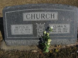
| Birth | : | 24 Apr 1854 Canada |
| Death | : | 10 Nov 1948 Pawnee City, Pawnee County, Nebraska, USA |
| Burial | : | DuBois Cemetery, Du Bois, Pawnee County, USA |
| Coordinate | : | 40.0231018, -96.0488968 |
| Description | : | TABLE ROCK ARGUS, OCT. 14, 1921- DuBOIS PRESS "Uncle Rafe" Church brought to this office Tuesday two stems of cotton on which were a half a dozen or more bolls of cotton. It was raised on his farm a short distance southeast of DuBois. Uncle Rafe claims, of course that he raised them, but then- well you folks have been here as long as we have. There is no doubt the cotton was grown on his place, but as to him doing the work necessary to bring it to maturity, u-m-m. However, be that as it may the fact that... Read More |
frequently asked questions (FAQ):
-
Where is Rufus Henry “Uncle Rafe” Church's memorial?
Rufus Henry “Uncle Rafe” Church's memorial is located at: DuBois Cemetery, Du Bois, Pawnee County, USA.
-
When did Rufus Henry “Uncle Rafe” Church death?
Rufus Henry “Uncle Rafe” Church death on 10 Nov 1948 in Pawnee City, Pawnee County, Nebraska, USA
-
Where are the coordinates of the Rufus Henry “Uncle Rafe” Church's memorial?
Latitude: 40.0231018
Longitude: -96.0488968
Family Members:
Parent
Spouse
Siblings
Children
Flowers:
Nearby Cemetories:
1. DuBois Cemetery
Du Bois, Pawnee County, USA
Coordinate: 40.0231018, -96.0488968
2. Cincinnati Cemetery
Du Bois, Pawnee County, USA
Coordinate: 40.0042000, -96.0274963
3. Friedens United Church of Christ Cemetery
Bern, Nemaha County, USA
Coordinate: 39.9929008, -96.0529480
4. Prairie Star Pioneer Cemetery
Du Bois, Pawnee County, USA
Coordinate: 40.0293000, -96.1041000
5. German Lutheran Cemetery
Bern, Nemaha County, USA
Coordinate: 39.9794500, -96.0234300
6. Saint Peters Evangelican Cemetery
Du Bois, Pawnee County, USA
Coordinate: 40.0010000, -96.1095000
7. Athens Cemetery
Richardson County, USA
Coordinate: 40.0449982, -95.9852982
8. Scotch Valley Cemetery
Nemaha County, USA
Coordinate: 39.9578018, -96.0699997
9. Coal City Cemetery
Seneca, Nemaha County, USA
Coordinate: 39.9498500, -96.0689600
10. Evergreen Cemetery
Pawnee County, USA
Coordinate: 40.0485992, -96.1417007
11. Pleasant Ridge Cemetery
Du Bois, Pawnee County, USA
Coordinate: 40.0156000, -96.1494000
12. Saint John Lutheran Cemetery
Bern, Nemaha County, USA
Coordinate: 39.9538900, -95.9977700
13. Four Mile Cemetery
Bern, Nemaha County, USA
Coordinate: 39.9857900, -95.9568900
14. Bern Cemetery
Bern, Nemaha County, USA
Coordinate: 39.9637299, -95.9781494
15. Pleasant Valley Cemetery
Pawnee County, USA
Coordinate: 40.0299988, -96.1554794
16. McCaffrey Cemetery
Nemaha County, USA
Coordinate: 39.9827100, -96.1474500
17. Four Mile Cemetery
Humboldt, Richardson County, USA
Coordinate: 40.0589000, -95.9455000
18. Bohemian Cemetery
Richardson County, USA
Coordinate: 40.1175003, -95.9955978
19. Dry Branch Pioneer Cemetery
Richardson County, USA
Coordinate: 40.1292000, -96.0100021
20. Pleasant Hill Cemetery
Richardson County, USA
Coordinate: 40.0471992, -95.9075012
21. East Amish Cemetery
Table Rock, Pawnee County, USA
Coordinate: 40.1310000, -96.0854000
22. Bestwick Cemetery
Sabetha, Nemaha County, USA
Coordinate: 39.9862595, -95.9100037
23. Williams Cemetery
Bern, Nemaha County, USA
Coordinate: 39.9219017, -95.9741974
24. Brewer Cemetery
Baileyville, Nemaha County, USA
Coordinate: 39.9556900, -96.1736500


